Download
1 / 42
450 likes | 806 Views
Introduction to Radar Doppler Spectra. Battaglia with contributions from P. Kollias , E. Luke, S. Kneifel , M.Maahn,F . Fabry. Doppler Radar spectra: a review back in ’73. Why bothering you with Doppler radars after more than 40 years?. Some research on Doppler spectra since1973.

E N D
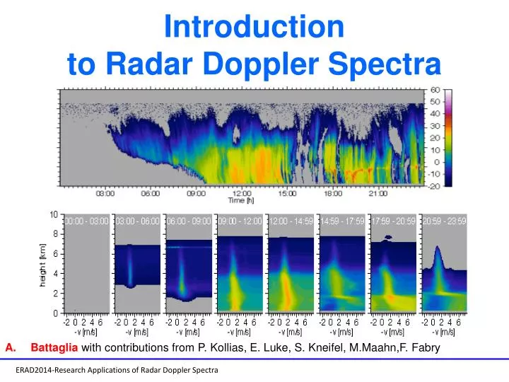
Introduction to Radar Doppler Spectra Battagliawith contributions from P. Kollias, E. Luke, S. Kneifel, M.Maahn,F. Fabry
Doppler Radar spectra: a review back in ’73 Why bothering you with Doppler radars after more than 40 years?
Some research on Doppler spectra since1973 182 peer reviewed paper citations (58 since 2010)+553 google scholar citations+many more Nick Guy, David P. Jorgensen, Kinematic and Precipitation Characteristics of Convective Systems Observed by Airborne Doppler Radar during the Life Cycle of a Madden–Julian Oscillation in the Indian Ocean, Monthly Weather Review, 2014, 142, 4, 1385. G. Yu, J. Verlinde, E. E. Clothiaux, Y.-S. Chen, Mixed-phase cloud phase partitioning using mm wavelength cloud radar Doppler velocity spectra, Journal of Geophysical Research: Atmospheres, 2014, 119, 12 FrédéricTridon, Alessandro Battaglia, PavlosKollias, Disentangling Mie and attenuation effects in rain using a Ka-W dual-wavelength Doppler spectral ratio technique, Geophysical Research Letters, 2013, 40, 20 Edward P. Luke, PavlosKollias, Separating Cloud and Drizzle Radar Moments during Precipitation Onset Using Doppler Spectra, Journal of Atmospheric and Oceanic Technology, 2013, 30, 8, 1656 Dong-KyunKim, Yeon-Hee Kim, Kwan-Young Chung, Vertical structure and microphysical characteristics of Typhoon Kompasu (2010) at landfall, Asia-Pacific Journal of Atmospheric Sciences, 2013, 49, 2, 161 Christopher R. Williams, Simultaneous ambient air motion and raindrop size distributions retrieved from UHF vertical incident profiler observations, Radio Science, 2002, 37, 2 Peter T. May, A. R. Jameson, Thomas D. Keenan, Paul E. Johnston, Chris Lucas, Combined Wind Profiler/Polarimetric Radar Studies of the Vertical Motion and Microphysical Characteristics of Tropical Sea-Breeze Thunderstorms, Monthly Weather Review, 2002, 130, 9, 2228 Robert Schafer, Susan Avery, Peter May, Deepak Rajopadhyaya, Christopher Williams, Estimation of Rainfall Drop Size Distributions from Dual-Frequency Wind Profiler Spectra Using Deconvolution and a Nonlinear Least Squares Fitting Technique, Journal of Atmospheric and Oceanic Technology, 2002, 19, 6, 864 PavlosKollias, R. Lhermitte, B. A. Albrecht, Vertical air motion and raindrop size distributions in convective systems using a 94 GHz radar, Geophysical Research Letters, 1999, 26, 20 P. E. Currier, S. K. Avery, B. B. Balsley, K. S. Gage, W. L. Ecklund, Combined use of 50 MHz and 915 MHz wind profilers in the estimation of raindrop size distributions, Geophysical Research Letters, 1992, 19, 10
Some research on Doppler spectra since1973 182 peer reviewed paper citations (58 since 2010)+553 google scholar citations Nick Guy, David P. Jorgensen, Kinematic and Precipitation Characteristics of Convective Systems Observed by Airborne Doppler Radar during the Life Cycle of a Madden–Julian Oscillation in the Indian Ocean, Monthly Weather Review, 2014, 142, 4, 1385. G. Yu, J. Verlinde, E. E. Clothiaux, Y.-S. Chen, Mixed-phase cloud phase partitioning using mm wavelength cloud radar Doppler velocity spectra, Journal of Geophysical Research: Atmospheres, 2014, 119, 12 FrédéricTridon, Alessandro Battaglia, PavlosKollias, Disentangling Mie and attenuation effects in rain using a Ka-W dual-wavelength Doppler spectral ratio technique, Geophysical Research Letters, 2013, 40, 20 Edward P. Luke, PavlosKollias, Separating Cloud and Drizzle Radar Moments during Precipitation Onset Using Doppler Spectra, Journal of Atmospheric and Oceanic Technology, 2013, 30, 8, 1656 Dong-KyunKim, Yeon-Hee Kim, Kwan-Young Chung, Vertical structure and microphysical characteristics of Typhoon Kompasu (2010) at landfall, Asia-Pacific Journal of Atmospheric Sciences, 2013, 49, 2, 161 Christopher R. Williams, Simultaneous ambient air motion and raindrop size distributions retrieved from UHF vertical incident profiler observations, Radio Science, 2002, 37, 2 Peter T. May, A. R. Jameson, Thomas D. Keenan, Paul E. Johnston, Chris Lucas, Combined Wind Profiler/Polarimetric Radar Studies of the Vertical Motion and Microphysical Characteristics of Tropical Sea-Breeze Thunderstorms, Monthly Weather Review, 2002, 130, 9, 2228 Robert Schafer, Susan Avery, Peter May, Deepak Rajopadhyaya, Christopher Williams, Estimation of Rainfall Drop Size Distributions from Dual-Frequency Wind Profiler Spectra Using Deconvolution and a Nonlinear Least Squares Fitting Technique, Journal of Atmospheric and Oceanic Technology, 2002, 19, 6, 864 PavlosKollias, R. Lhermitte, B. A. Albrecht, Vertical air motion and raindrop size distributions in convective systems using a 94 GHz radar, Geophysical Research Letters, 1999, 26, 20 P. E. Currier, S. K. Avery, B. B. Balsley, K. S. Gage, W. L. Ecklund, Combined use of 50 MHz and 915 MHz wind profilers in the estimation of raindrop size distributions, Geophysical Research Letters, 1992, 19, 10 Commonality: exploitation of information in Doppler spectra collected by profiling radars, ranging from wind profilers to cloud radars and their combinations for cloud and precipitation microphysics and dynamics.
Summer School - Finland The cloud radar grand challenge The “cloud problem”, i.e., the understanding of the microphysical, dynamical and radiative processes that act at the cloud scale and their accurate representation in numerical models. Clouds are a bit of a wild card in future climate simulations (variations in cloud forcing/feedbacks between different climate models can be as large as the entire radiative forcing due to a doubling of CO2 (4W/m2) Cloud radars are a key observing platform for probing clouds (fifty years after the first attempts and despite the advancements in the retrieval of raindrop size distribution, the retrieval of cloud droplet and ice crystals SD from Doppler spectra remains still a grand challenge (but with renewed hopes). ) Projections of future global average surface temperature for various IPCC 4 scenarios. The graph shows temperature changes as compared with the 1980-1999 average.
Why are clouds so tough? • Huge range of space and time scales • Hard to validate remote sensing of clouds • Explosive growth – unstable – chaos producers • Sub-grid scale in climate models • At the center of the aerosol-cloud-precipitation chain and linking dynamics-thermodynamics and radiative effects • What cloud variables do people care about? • Coverage and overlap • Phase • Particle concentration • Water content (liquid/ice) • Vertical velocity microphysics Observing systems capable of providing improved descriptions of micro- and macro-physical structure of clouds and of cloud processes over a wide range of spatial and temporal scales will advance our understanding of the Earth system
Summer School - Finland The cloud radar problem The dependency to D6 - challenges our ability to study transition regimes (cloud to drizzle, mixed-phase clouds) and to retrieve cloud properties (mass, number concentration)
Retrieval of lower particle size distribution moments Use a specified functional form for the particle size distribution (model or retrieval imposed) We want lower moments to evaluate numerical models Mass content (p = 3) Concentration (p = 0) Radar reflectivity is related to the 6th moment (p = 6) Extracting lower moments is subject to large errors introduced by the assumed shape of the particle size distribution
Why this research bloom related to Doppler radars? Tx: EIK, 1.7/1.7 kW Duty Cycle: 5%/1% Antenna: 0.33°/0.29° Diameter: 1.82/0.9 m A potpourri of Doppler systems is now available, the majority of which with multi-frequency capabilities (including mm-wave radars). PROS CONS Better sensitivity, clutter suppression Large Mie effects (sizing capability) Unprecedented temporal/spatial res/ portability Strong attenuation in heavy rain
The Atmospheric Radiation Measurement (ARM) Climate Research Facility Mather and Voyles, BAMS, 2012 Primary goal is to improve the treatment of cloud and radiation physics in global climate models in order to improve the climate simulation capabilities of these models (www.arm.gov) • The ARM program has deployed the operational cloud profiling radars • Ka band radar (MMCR) for fifteen years • W-band(WACR) for more than five years • The ARM program has recently deployed • Operational scanning radars to facilitate the research on 3D mapping of c louds and precipitation • Several scanning dual frequency Doppler radars
Cabauw, The Netherlands 35-GHz cloud radar (KNMI) SIRTA, Palaiseau (Paris), France 94-GHz Doppler Radar EU CloudNet project Summer School - Finland Chilbolton, UK 35/94-GHz Doppler cloud radars
German Supersites Summer School - Finland Integrated Observing Network MIRA +MRR radars
Air- and ship-borne MM-wave Radar Platforms NCAR High-performance Instrumented Airborne Platform for Environmental Research (HIAPER) NASA DC8/ER-2 & Global Hawk Unmanned Aerospace Vehicles (UAV) NRC Canada Convair-580 cloud radar (W/X-band) University of Wyoming King Air W-band Europe HALO (Ka)+RASTA (W) ERAD Short Course on Millimeter Wavelength Radars NOAA Stabilized 94-GHz Doppler Radar FMCW 94-GHz Doppler Radar DOE-AMF MAGIC Deployment (2012-2013)
Coming next ….. Next generation of spaceborne rain/cloud radar will have Doppler capabilities!
Doppler Shift: A frequency shift that occurs in electromagnetic waves due to the motion of scatterers toward or away from the observer (famous example==red shift of star-light). Doppler radar: A radar that can determine the frequency shift through measurement of the phase change that occurs in electromagnetic waves during a series of pulses (peculiarity of MW). Analogy: The Doppler shift for sound waves is the frequency shift that occurs as race cars (trains) approach and then recede from a stationary observer
The electric field of a transmitted wave phase The returned electric field at some later time back at the radar If the object is moving the range is time-dependent The time it took to travel Amplitude is affected by range and reflectivity Substituting: The received frequency can be determined by taking the time derivative of the quantity in parentheses and dividing by 2p
Doppler spectra The Doppler frequency is negative (lower frequency, red shift) for objects receding from the radar (vr>0) RED SHIFT The Doppler frequency is positive (higher frequency, blue shift) for objects approaching the radar (vr<0) VIOLET SHIFT In VPR the radial velocity accounts for hydrometeor terminal velocity and vertical wind NB: there is no consensus on the convention on velocity signs
Magnitude of the Doppler Shift Transmitted Frequency W band X band C band S band 94 GHz 9.37 GHz 5.62 GHz 3.0 GHz Radial velocity 625 Hz 62.5 Hz 37.5 Hz 20.0 Hz 6.25 KHz 625 Hz 375 Hz 200 Hz 31.25 KHz 3125 Hz 1876 Hz 1000 Hz 1 m/s 10 m/s 50 m/s • These frequency shifts are very small (compared to the radar-frequency 6 order of magnitude lower): for this reason, Doppler radars must employ very stable transmitters and receivers (klystron or magnetron systems)
Mapping velocities into particle size: rationale Different particles have different velocities with larger particles typically falling faster. This is the key feature for using Doppler spectra in microphysical retrievals. Unambiguous (hydrometeor-type dependent) relationships between particle fall speeds and diameters mirror into an unambiguous relationship between Doppler frequency shifts and diameters profile of Doppler spectra can provide range-resolved information about the size distribution of the particles contained in the radar backscattering volume. Saturation of terminal velocities Raindrops terminal velocities
Velocity-size relationship for other hydrometeors There is a larger dynamics in terminal velocities for rain than for graupel and snow snow is particularly challenging. On the other hand the difference between different hydrometeors immediately helps in hydrometeor classification.
Spectral reflectivity factor PSD 2-way attenuation Radar equation for distributed targets Radar volume at range r Particle size distribution in 1/(m3mm) From Mie/scattering theory When considering the return power at different frequencies we can define the spectral power Applying the same reasoning to the reflectivity factor we can define a spectral reflectivity factor Jacobian for mapping D into v We tend to refer this to the ``Doppler spectrum’’
Broadening of an ideal Doppler spectra for distributed target Velocity of individual targets in contributing volume vary due to: Differential fall velocity of targets (particularly at high elevation angles, e.g. for vertical incidence) 2) Vertical wind speed and turbulence 3) Wind shear 4) Finite beamwidth
Ideal quiet air Doppler spectrum RR=5 mm/h Spectral reflectivity factor
Ideal quiet air Doppler spectrum: RR=5 mm/h Spectral reflectivity factor Rayleigh region Ice particles: more difficult to compute sback (Stefan’s talk) Mie oscillations sizing info
Ideal quiet air Doppler spectrum: RR=5 mm/h Spectral reflectivity factor Raindrop terminal velocity Not a good mapping between diameters and velocities: all large raindrops end up in the same velocity bin
Ideal quiet air Doppler spectrum: RR=5 mm/h Spectral reflectivity factor Linear units! The dynamic range of rain reflectivity values is strongly reduced at W-band
Ideal quiet air Doppler spectrum: RR=5 mm/h Spectral reflectivity factor Linear units! The dynamic range of rain reflectivity values is strongly reduced at W-band Effect of frequency
Ideal quiet air Doppler spectrum: RR=5 mm/h Spectral reflectivity factor Region where multi-frequency approach can be useful Kollias et al., 2002: detection of the Mie notch at D = 1.65 mm, i.e. Vfall ~= 5.8 m s-1
Ideal quiet air Doppler spectrum: RR=5 mm/h Spectral reflectivity factor Kollias et al., 2002: detection of the Mie notch at D = 1.65 mm, i.e. Vfall ~= 5.8 m s-1
The moments of the Doppler spectra Reflectivity Mean radial velocity Spectral width Ed will introduce additional spectral moments!
Moments of rain spectra for RR=5 mm/h Spectral reflectivity factor MP distribution Only due to PSD
Inversion and retrieval of PSD Spectral reflectivity factor If the measured spectrum had this shape then The particle size distribution N(D) can be directly derived from the radar return power S(V) Is this inversion possible? N.B This is what is done in several algorithm, e.g. the MRR retrieval. But Atlas et al. [1973] already recognized that even when updrafts are estimated to better than about 0:25m/s errors in the concentration of raindrops for certain size ranges may exceed a factor of two.
Effect of Vertical Air motion and turbulence The presence of turbulent vertical air motion add a Gaussian distributed random component to the terminal velocity of the raindrops In reality there is always turbulent air motions in our radar spectrum: some droplets will be slow down due to turbulent upward motions, some of them accelerate due to downward motions. Different size particles One size particles
Effect of turbulence on W-band spectrum One order of magnitude First Mie notch There is a smearing of the no air motion Doppler spectrum, first Mie notch can disappear
What controls the magnitude of the broadening σt? st related to the eddy dissipation rate e Kolgomorov Unresolved scales of turbulence smallest scale probed by the Doppler radar length scale describing the scattering volume dimension includes large eddies traveling through the sampling volume within the radar dwell time The energy (variance) can be estimated using the variance of the mean Doppler velocity Retrieve the eddy dissipation rate ε O’Connor et al. 2005; Bouniol et al., 2003, Kollias et al., 2001
Turbulence broadeningσt Detailed formulas can be found In Frisch and Clifford, JAS, 1974 Kollias et al., 2002
Wind shear broadening σsh If the vertical wind is changing inside the radar backscattering volume (either moving parallel or perpendicular to the radar beam) this will add extra broadening to the spectrum Linear wind fields result in Doppler spectrum broadening (detailed formulas in Doviak-Zrnic). Discontinuous (step function) wind field profile results in bimodal Doppler spectrum.
Wind shear broadening σsh If the vertical wind is changing inside the radar backscattering volume (either moving parallel or perpendicular to the radar beam) this will add extra broadening to the spectrum Wind shear of 10-2-10-1 s-1 are possible close to convective core w variation of 10 m/s in 100m Kollias et al., JAS, 2001
Finite beamwidth broadening σB The cross-beam wind velocity induces a broadening proportional to the beamwidth because of the radial component of the cross-beam wind vector pointing in directions away from the beam axis Particles along the green line appear to recede from the radar For a Gaussin circular antenna U For a 9 degree beamwidth wind profiler (typical 915-MHz) σB is 1.4 ms-1 for a 30 ms-1 cross wind velocity For a 0.5 degree beamwidth cloud radar (typical cloud radar) σBis 0.08 ms-1
Spaceborne-radars: finite beamwidthbroadening σB The same reasoning applies if the radar moves. LEO satellite moves quite fast huge effect even with Small beamwidths EarthCARE CPR For the EarthCARE CPR, the beamwidth is 0.095 degrees but the satellite (cross beam wind) is 7,600 ms-1 and σBis 3.7 ms-1 Apparently receding from radar/ going downward Approaching /upward That’s why Doppler spectra from air-borne and Space-borne radars are not so useful
Particle size decreasing Particle size increasing turbulence updrafts downdrafts Radar Doppler Spectrum P light rain The quasi-unique relationship between D and vfall(D) does not translate in a unique relationship between D and Doppler shift because of the presence of vertical wind and broadening effects (turbulence, cross-wind,..) moderate rain drizzle Received Power (dB) heavy rain * * * * * * * * * noise * * ice/snow cloud * * rising particles Velocity (m/s) falling particles
Retrieval: Convolution of Microphysics with Dynamics To gain the best insight into the properties of observed particles, we must understand the motion of the surrounding air. Cloud radars don’t “see” the air directly. We must infer air motion through the motion of particles of which we have incomplete understanding. • Several techniques proposed for retrieving simultaneously dynamics and microphysics. Doppler techniques can be complemented by multi-wavelengthcapabilities based on Bragg vs Rayleigh, Rayleigh vs Mie effects. Next talk examples of: • Drizzling warm marine stratocumulus (Ed) • Non precipitating fair weather cumulus (Ed) • Clear air insect clutter (Ed) • Continental stratiform rain (Fred&Ed) • Ice and mixed-phase clouds (Stefan)