Download
1 / 76
760 likes | 767 Views
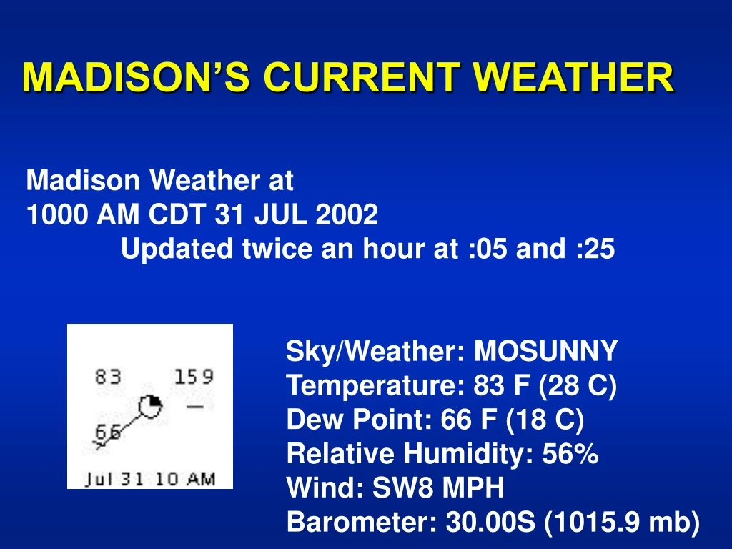
MADISON’S CURRENT WEATHER. Madison Weather at 1000 AM CDT 31 JUL 2002 Updated twice an hour at :05 and :25 Sky/Weather: MOSUNNY Temperature: 83 F (28 C)

E N D
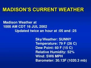
MADISON’S CURRENT WEATHER Madison Weather at 1000 AM CDT 31 JUL 2002 Updated twice an hour at :05 and :25 Sky/Weather: MOSUNNY Temperature: 83 F (28 C) Dew Point: 66 F (18 C) Relative Humidity: 56% Wind: SW8 MPH Barometer: 30.00S (1015.9 mb)
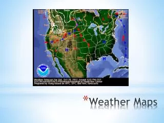
Current Surface Weather Map with Isobars (“iso” = equal & “bar” = weight), Fronts and Radar
Current Temperatures (°F) & Isotherms(“iso” = equal +”therm” = temperature)
Current Surface Weather Map with Isobars (“iso” = equal & “bar” = weight), Fronts and Radar
Current Surface Winds with Streamlines & Isotachs (“iso” = equal & “tach” = speed) H L L L L H L H L L H H L H L L L L H H H H
Current 5,000 ft. Windswith Streamlines & Isotachs (“iso” = equal & “tach” = speed)
Current 10,000 ft. Windswith Streamlines & Isotachs (“iso” = equal & “tach” = speed)
Current 34,000 ft. Winds & Jet Streamwith Streamlines & Isotachs (“iso” = equal & “tach” = speed) Trough Ridge
ATM OCN 100 - Spring 2002 LECTURE 20 (con’t.) THE THEORY OF WINDS: PART III - RESULTANT ATMOSPHERIC MOTIONS (con’t.) • Introduction & Assumptions Buys-Ballot Law Hydrostatic Balance Relationship • Horizontal Equation of Motion Local Winds Geostrophic Winds Winds in Friction Layer
Summary of Forces for selected modelsSee Table 9.1 Moran & Morgan (1997) MODELS
Flow in Friction LayerSee Fig. 9.15 Moran & Morgan (1997) No Friction Geostrophic Friction Subgeostrophic
Flow in Friction LayerSee Fig. 9.15 Moran & Morgan (1997) Vector Magnitude1. Depends on Friction 2. Less than Geostrophic Wind • Vector Direction: • Angles across isobars • Toward Low in either hemisphere
Variation of Friction Effects with HeightSee Fig. 9.16 Moran & Morgan (1997)
Variations in Surface Roughness leads to divergence/convergence patternsSee Fig. 9.22 Moran & Morgan (1997)
F. CURVED, HORIZONTAL BALANCED MOTION - “GRADIENT FLOW” • Assumptions • Without Friction • Two Cases
Summary of Forces for selected modelsSee Table 9.1 Moran & Morgan (1997)
“GRADIENT” FLOW: ANTICYCLONIC CaseSee Fig. 9.13 Moran and Morgan (1997):
“GRADIENT” FLOW: ANTICYCLONIC CaseSee Fig. 9.13 Moran and Morgan (1997):
“GRADIENT” FLOW: CYCLONIC CaseSee Fig. 9.14 Moran and Morgan (1997):
“GRADIENT” FLOW: CYCLONIC CaseSee Fig. 9.14 Moran and Morgan (1997):
G. GRADIENT FLOW WITH FRICTION • Resultant flow with Friction FCentripetal =FPG,H + FCor + FFriction (A vector summation).
Summary of Forces for selected modelsSee Table 9.1 Moran & Morgan (1997)
G. GRADIENT FLOW WITH FRICTION • Resultant flow with Friction FCentripetal =FPG,H + FCor + FFriction (A vector summation). • Applicability to the Atmosphere • Situation • Resultant Diagrams
Anticyclonic Flow in Friction Layer Fig. 9.17 Moran & Morgan (1997)
Cyclonic Flow in Friction Layer Fig. 9.18 Moran & Morgan (1997)
Near-Surface Windsin each HemisphereSee Figs. 9.17 & 9.18 Moran & Morgan (1997)
Summary of Forces for selected modelsSee Table 9.1 Moran & Morgan (1997)
H. RELATIONSHIPS BETWEEN HORIZONTAL & VERTICAL MOTIONS • Dilemma • Convergence / Divergence • Principle of Mass Continuity
H. RELATIONSHIPS BETWEEN HORIZONTAL & VERTICAL MOTIONS (con’t.) • Dines’ Compensation • Resultant Vertical Motions • Implications of Dines' Compensation
I. VORTICES & VORTICITY • Definitions • Characteristic Vortex Features
Vorticity Cyclonic Vorticity • Types of Vorticity Anticyclonic Vorticity
Vorticity • Conservation of Vorticity
ATM OCN 100 - Summer 2002 LECTURE 24 PLANETARY-SCALE CIRCULATION of EARTH'S ATMOSPHERE A. INTRODUCTION • Why do weather systems in ...mid latitudes move from west to east? but..tropics move from east to west?
Year 2001 Hurricane/Tropical Storm Tracks in North Atlantic 8 Hurricanes 7 Trop. Storms
Year 2001 Hurricane/Tropical Storm Tracks in Eastern/Central North Pacific 8 Hurricanes 7 Trop. Storms
B. GLOBAL SCALE PREVAILING SURFACE WINDS • Historical Wind Observations • Popular Names of Principal Prevailing Surface Wind Regimes • Where…
Popular Names of Global-Scale Prevailing Wind Belts Polar easterlies Westerlies Horse Latitudes NE Trades Doldrums SE Trades Horse Latitudes Westerlies Polar easterlies
Average Air Pressure & Atmospheric Circulation • Polar Highs (or anticyclones) • Subpolar Lows (or cyclones) Subtropical High Pressure Cells IntertropicalConvergence Zone (ITCZ) ~ Subtropical High Pressure Cells Subpolar Lows (or cyclones
C. AVERAGE SEA-LEVEL PRESSURE PATTERNSSee Table 10.1 Moran & Morgan (1997) • Relationships between Prevailing winds & Major Pressure Patterns