Download
1 / 35
350 likes | 456 Views
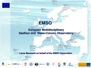
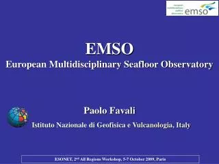
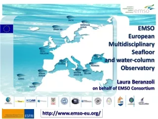
Paolo Favali Istituto Nazionale di Geofisica e Vulcanologia, Italy. EMSO European Multidisciplinary Seafloor Observatory. http://www. emso-eu.org/. S. N. GB. IR. NL. D. F. I. P. E. GR. TU.

E N D
Paolo Favali Istituto Nazionale di Geofisica e Vulcanologia, Italy EMSO European Multidisciplinary Seafloor Observatory http://www. emso-eu.org/
S N GB IR NL D F I P E GR TU EMSO, a Research Infrastructure of the ESFRI Roadmap,is the European network of fixed seafloor and water column observatories constituting a distributed infrastructure for long-term (mainly) real-time monitoring of environmental processes In the EC-FP7 EMSO Preparatory Phase(12 countries) started in April 2008 for 4 years with the aim to design and create the legal entity in charge of the infrastructure
EMSO is A European distributed marine Research Infrastructure: permanent, large-scale, deep-sea laboratory to address the key issues Marine Ecosystems Climate Change Geo-Hazards
Features and types of Fixed Observatories Unmanned, multi-sensor platforms to make measurementsfrom above the air-sea interface to below the seafloor, and with different configurations related to the communications: 1)Stand-alone and delayed mode observatories 2) Mooring and seafloor observatories with acoustic or cabled capabilities
Mooring with satellite communications Cabled configuration NRC, 2003 Source “Implementation Strategies for ESONET and EMSO Appendix A”, 2009
multiparametric long-term (years) time-series • seabed and water column measurements • common set of sensors for basic measurements and further sensors for specific purposes Observatory Measurements • Nutrient analyzers • pH, Eh and alkalinity • hydrocarbon fluorescence • In situ Mass spectrometer • Particle flux trap • Image based particle flux • Pigment fluorescence • Deep biosphere sensors • Time-Lapse Cameras • Holographic imaging • Video • Passive acoustics • Active acoustics • Zooplankton sampling • In situ sample processors with molecular/ genetic probes • In situ respiration • Seismic ground motion • • Gravity • • Magnetism • • Geodesy and seafloor deformation • Fluid related processes monitoring • • Chemical and Aqueous Transport (CAT) • • Pore pressure • • Gas hydrate monitoring • • Dissolved Fe, Mn and sulfide species • • Acoustic tomography • • CTD equipment for hydrothermal vents • • Methane • • Carbon dioxide • • Heat Flow
Unravelling the complexity: interactions between atmosphere, ocean, earth processes Ruhl et al., 2010 (submitted)
EMSO Mission is to address the following needs: • Sustained observations are essential at a sufficiently high frequency to explore the time changing properties of the oceanic environment • Investigation of the complex interrelations between processes and properties from the top of the ocean to the seabed beneath: - Short-time scales (minutes, hours to days) - Longer-time scales (annual to decadal)
Open Access Modality The EMSO real time or near-real time data will be available through internet to scientists and they will run their experiments remotely Open Access (data, facilities and personnel) does not mean unrestricted and unlimited access Access rules will be defined and will depend on: Country involvement in the RI Profile of the user (scientist, industry or others)
e-Infrastructures for data management, communication and decision making Real-time and near-real-time data require appropriate storage, data quality assessment and processing/modelling addressable through e-infrastructures Web-based platform for data and instrumentation remote access
History of European Observatory Initiatives • Feasibility studies: ABEL, DECIBEL (FP3, 1990-1993) • GEOSTAR 1 & 2 (FP4, 1995-2001) • NEMO-SN1 (Italian funds & FP6, 2000-ongoing) • ASSEM (FP5, 2002-2004) • ESONET CA (FP5, 2002-2004) • ORION-GEOSTAR-3 (FP5, 2002-2005) • ESONIM (FP6, 2004-2007) • EXOCET/D (FP6, 2004-2007) • NEAREST (FP6, 2006-2010) • ESONET NoE (FP6, 2007-2011) • EUROSITES (FP7, 2008-2010) • HYPOX (FP7, 2009-2011) • EMSO Preparatory Phase (FP7, 2008-2012)
SN3 GEOSTAR SN4 SN1 GMM MABEL (SN2) GEOSTAR-class SEAFLOOR OBSERVATORIES Favali et al., 2006b; Favali & Beranzoli, 2006; 2009b
The ongoing ESONET Demonstration Missions (DMs) and S&T activities progress towards “permanent” installations AOEM-DM Mainly: Geo-Hazards Climate change & Ecosystem LOOME-DM MARMARA-DM MODOO-DM MOMAR-DM LIDO-DM The EMSO nodes are located in the ESONET key sites
Marmara Sea Partners: Turkey, Italy, France EC-ESONET-MARMARA-DM (exp. Sept’09-ongoing) eastern part of the sea at the westernmost end of the fault rupture caused by the 1999 Izmit earthquake. SN4 location Main goals: Relationship between Seismicity & Gas seepage
ML=4.7 Gulf of Cadiz (Jan.11, 2008) Portugal MODUS N-E Atlantic SISM GEOSTAR GEOSTAR Gulf of Cadiz 85 km off-shore 3200 m w.d. ACC R/V Sarmiento de Gamboa Iberian Margin Acoustically linked observatory Partners: Portugal, Spain, Italy, Germany, France, Morocco EC-NEAREST (exp. Aug.’07-Aug.’08) EC-ESONET-LIDO-DM (exp. Nov’09-ongoing) Main goals: Geo-Hazards & Bio-acoustics
Western Ionian Sea The 1st cabled prototype node (from 2005) • 2005 Real-time data transmission • Recovery for refurbishment • 2010 Re-deployment (ESONET-LIDO-DM) Optical sensors Electronic vessels Main goals: Geo-Hazards & Bio-acoustics, Test site for Neutrino Telescope Partners: Italy, Portugal, Spain, Germany, France East Sicily (Western Ionian Sea) Synergy between the 2 ESFRIinfrastructures: KM3NeT and EMSO
Running S&T activities Permanent infrastructures Test sites (shallow water) Status of the nodes
Governance StructureERIC Statute in preparation GOVERNING BODIES Assembly of Members - AoM Director General - DG Finance Committee - FC Scientific Advisory Committee - SAC ORGANISATION Executive Board - EB Network Control Department - NCD Regional Departments - RDs
Key elements EMSO will have: Central co-ordination Regional Departments Arctic Iberian margin …RDs… Secretariat (Italy) Ligurian Sea Marmara Sea W. Ionian Sea Hellenic Arc
2010 2011 2012 2013-2015 2016-2020 EMSO Implementation Plan
Benefits for the Scientific Community • EMSO brings about a breakthrough on: • Geo-hazard warning • Environmental policies • Understanding the climate impacts and the anthropo- genic forcing • High-level training and education of researchers, engi- neers and technicians • Knowledge and technology transfer • Interaction with industry
Interactions with stakeholders Great potential to have a large number of users outside the Scientific Community Civil Protection (e.g., tsunami early warning, disaster management) Governmental environmental monitoring organisations Operational oceanography Fisheries management
Links with Industry Involvement of the Industry (large and SMEs) within EMSO is at multiple level As RI component developer/supplier and service provider Sensors, acquisition systems, cables, software, etc... Ship-time As user Existing involvement: Oil companies Potential: biotechnology, materials technology, others…
The Level of Services • Hosting scientific experiments • Technical Assistance • Power supply and data transmission (e.g., junction boxes) • Logistics (e.g., ships, underwater vehicles) • Test beds for • Validation of prototype of underwater sensors • Validation of new devices for underwater applications • Materials in corrosive ambient and lasting high pressure • Service to other sites • Sites different from the initial EMSO sites of interest of • stakeholders (e.g., oil & gas companies)
A different approach to education about the role of the oceans Education and recreational activities (aquaria, etc…): real-time images from the abyss (courtesy of J. Delaney, OOI)
Benefits for the Society Natural hazard mitigation Understanding climate changes Marine environment preservation and sustainable development Strong impact on SMEs in marine technologies Impact on education and job creation opportunities
SIOS EMSO complementary/synergic interactions with other ESFRI Infrastructures
Long-Term, Real-Time Cabled Observatories DONET (Japan) ● ● ● ● MACHO (Taiwan) ● ● ● MARS (USA) NEPTUNE (Canada) OOI (USA) VENUS (Canada) ● ● ● EMSO ● ● ● ● ● ● ● ●
Vision • Integrate and enhance the existing infrastructures • Expand the observations in critical, representative locations in particular environments • The overall vision is to develop a global system of multidisciplinary and interdisciplinary sustained observatory networks
Arctic Norwegian Margin Nordic Sea Porcupine Abyssal Plain Black Sea Ligurian Sea Azores Islands Marmara Sea Iberian Margin Western Ionian Sea Hellenic Arc http://www. emso-eu.org/ Thank you for your attention Paolo Favali EMSO-PP Co-ordinator emsopp@ingv.it