Download
1 / 21
230 likes | 441 Views
Data Collection Methods. BluFax : vehicle identification using bluetooth MAC addresses – provides corridor traffic patterns (origin-destination data) and vehicle travel-times in SR-91 corridor study area

E N D
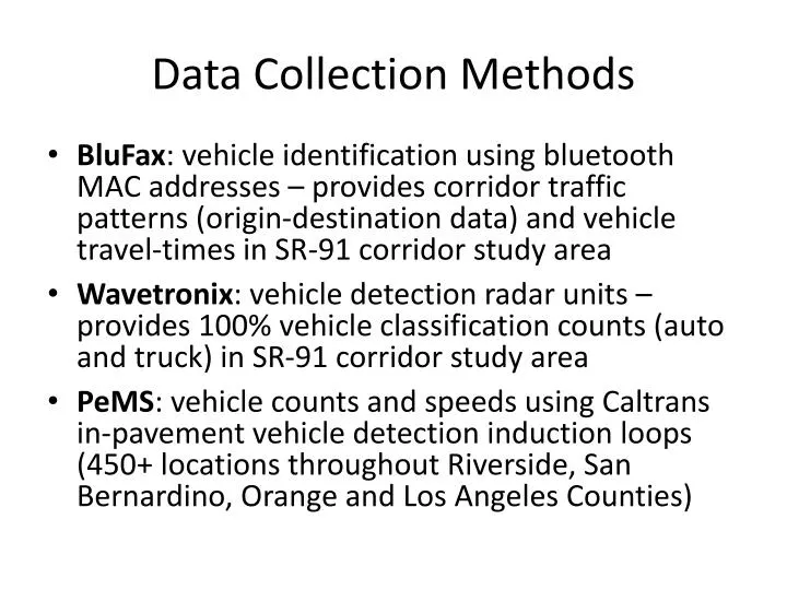
Data Collection Methods • BluFax: vehicle identification using bluetooth MAC addresses – provides corridor traffic patterns (origin-destination data) and vehicle travel-times in SR-91 corridor study area • Wavetronix: vehicle detection radar units – provides 100% vehicle classification counts (auto and truck) in SR-91 corridor study area • PeMS: vehicle counts and speeds using Caltrans in-pavement vehicle detection induction loops (450+ locations throughout Riverside, San Bernardino, Orange and Los Angeles Counties)
SR-91 Corridor Travel Patterns • BluFax and Wavetronix data was collected between November 1st and November 10th 2010 • Data was aggregated to provide average weekday AM and PM peak period travel patterns consistent with modeling time periods • Combining the BluFax origin-destination traffic data (in percent) with the Wavetronix classification count data provides complete corridor AM and PM peak period travel patterns
SR-91 Corridor: BluFax and Wavetronix Data Collection Locations 5 6 4 2 1 3 7
SR-91 EASTBOUND AM Percent AM Volume
SR-91 EASTBOUND PM Percent PM Volume
SR-91 WESTBOUND AM Percent AM Volume
SR-91 WESTBOUND PM Percent PM Volume
SR-71 SOUTHBOUND AM Percent AM Volume
SR-71 SOUTHBOUND PM Percent PM Volume
I-15 SOUTHBOUND AM Percent AM Volume
I-15 SOUTHBOUND PM Percent PM Volume
I-15 NORTHBOUND AM Percent AM Volume
I-15 NORTHBOUND PM Percent PM Volume
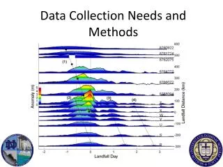
SR-91 Corridor Travel-times • BluFax data collected Nov 1 Nov 10, 2010 • Data was aggregated to provide average weekday travel-time summations in 15-minute increments • Travel-time graphics (plots) reveal congested freeway segments and time periods • PeMS data provides weekday average hourly traffic speeds at 450+ Caltrans freeway locations adjacent or relevant to the SR-91 corridor • PeMS data still being analyzed – data summaries before end of December
SR-91 Corridor: BluFax and Wavetronix Data Collection Locations 5 6 4 2 1 3 7