Download
1 / 34
340 likes | 344 Views
Learn about fronts, including cold and warm fronts, and their impact on weather patterns. Explore the formation of midlatitude cyclones and the development of hurricanes, thunderstorms, and tornadoes. Discover the characteristics and stages of severe weather events.

E N D
Section 2: Fronts Preview • Key Ideas • Fronts • Types of Fronts • Polar Fronts and Midlatitudes Cyclones • Severe Weather
Key Ideas • Comparethe characteristic weather patterns of cold fronts with those of warm fronts. • Describehow a midlatitude cyclone forms. • Describethe development of hurricanes, thunderstorms, and tornadoes.
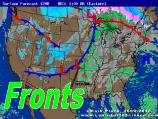
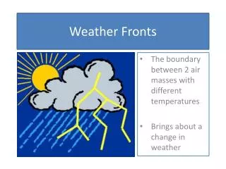
Fronts • A cool air mass is dense and does not mix with the less-dense air of a warm air mass. • Thus, a boundary, called a front, forms between air masses. • Changes in middle-latitude weather usually take place along the various types of fronts. • Fronts do not exist in the tropics because no air masses that have significant temperature differences exist there.
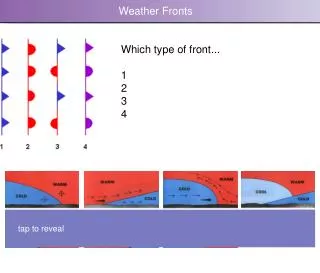
Types of Fronts Cold Fronts • cold front the front edge of a moving mass of cold air that pushes beneath a warmer air mass like a wedge • If the warm air is moist, clouds will form. Large cumulus and cumulonimbus clouds typically form along fast-moving cold fronts. • A long line of heavy thunderstorms, called a squall line, may occur in the warm, moist air just ahead of a fast-moving cold front. • A slow-moving cloud front typically produces weaker storms and lighter precipitation than a fast-moving cold front does.
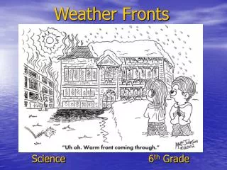
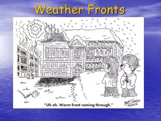
Types of Fronts, continued Warm Fronts • warm front the front edge of advancing warm air mass that replaces colder air with warmer air • The slope of a warm front as it , moves into a colder air mass is gradual. • Because of this gentle slope, clouds may extend far ahead of the surface location, or base, of the front. • A warm front generally produces precipitation over a large area and may occasionally cause violent weather.
Warm and Cold Fronts Cold Front sharp slope short span of severe weather Warm Front has a gradual slope with extended periods of precipitation.
Types of Fronts, continued Stationary and Occluded Fronts • stationary front a front of air masses that moves either very slowly or not at all • occluded front a front that forms when a cold air mass overtakes a warm air mass and lifts the warm air mass off the ground and over another air mass
Polar Fronts and Midlatitudes Cyclones • Over each of Earth’s polar regions is a dome of cold air that may extend as far as 60° latitude. • The boundary where this cold polar air meets the tropical air mass of the middle latitudes is called the polar front. • Waves commonly develop along the polar front.
Polar Front formation The polar front is the cold front that separates the main body of colder, drier air to the north from warmer, moister air to the south.
Polar Fronts and Midlatitudes Cyclones, continued • Waves are the beginnings of low-pressure storm centers called midlatitude cyclones or wave cyclones. • midlatitude cyclone an area of low pressure that is characterized by rotating wind that moves toward the rising air of the central low-pressure region • Hurricanes, cyclones and typhoons are all the same storm system in different oceans
Polar Fronts and Midlatitudes Cyclones, continued The diagram below shows the different stages of a midlatitude cyclone.
Polar Fronts and Midlatitudes Cyclones, continued Anticyclones • Unlike the air in the midlatitude cyclone, the air in an anticyclone sinks and flows outward from a center of high pressure. • Because of the Coriolis effect, the circulation of air around an anticyclone is clockwise in the Northern Hemisphere. • Anticyclones bring dry weather, because their sinking air does not promote cloud formation. (Why?)
Reading Check How is the air of an anticyclone different from that of a midlatitude cyclone? The air of an anticyclone sinks and flows outward from a center of high pressure. The air of a midlatitude cyclone rotates toward the rising air of a central, low-pressure region.
Severe Weather Thunderstorms • thunderstorma usually brief, heavy storm that consists of rain, strong winds, lightning, and thunder • Thunderstorms develop in three distinct stages. • In the cumulus stage, warm, moist air rises, and the water vapor within the air condenses to form a cumulus cloud. • In the mature stage, the cloud rises and becomes a dark, cumulonimbus cloud from which heavy, torrential rain and hailstones may fall. • During the dissipating stage, the strong downdrafts stop air currents from rising. The thunderstorm dissipates as the supply of water vapor decreases.
Severe Weather, continued Lightning • During a thunderstorm, clouds discharge electricity in the form of lightning. • The released electricity heats the air, and the air rapidly expands and produces a loud noise known as thunder. • For lightning to occur, the clouds and ground must have areas that carry distinct electrical charges. • Lightning is a huge spark that travels within the cloud, or between the cloud and the ground, to equalize the electrical charges.
Severe Weather, continued Hurricanes • hurricanea severe storm that develops over tropical oceans and whose strong winds of more than 120 km/h spiral in toward the intensely low-pressure storm center • A hurricane begins when warm, moist air over the ocean rising rapidly. • Moisture in the rising warm air cools and condenses, energy in the form of latent heat is released. • So when the storm hits land it loses energy – No latent heat from water
Severe Weather, continued Hurricanes, continued • A fully developed hurricane consists of a series of thick cumulonimbus cloud bands that spiral upward around the center of the storm. • The most dangerous aspect of a hurricane is a rising sea level and large waves, called a storm surge. • Every hurricane is categorized on the Saffir-Simpson scale by using several factors. These factors include central pressure, wind speed, and storm surge.
Severe Weather, continued Tornadoes • The smallest, most violent, and shortest-lived severe storm is a tornado. • tornadoa rotating column of air that has very high wind speeds and low pressure that maybe visible as a funnel-shaped cloud • A tornado forms when a thunderstorm meets high-altitude horizontal winds. These winds cause the rising air in the thunderstorm to rotate.
Severe Weather, continued Tornadoes, continued • A storm cloud may develop a narrow, funnel-shaped rapidly spinning extension that reaches downward and may or may not touch the ground. • The tornado generally moves in a wandering, haphazard path. • The destructive power of a tornado is due to mainly the speed of the winds and the very low pressure in the storm center. These winds may reach speeds of more than 400 km/h.