Download
1 / 6
60 likes | 152 Views
NEPAnode is a Geospatial Data and Document Management System http://nepanode.anl.gov It provides a centralized and collaborative site to access the data used and documents referenced in NEPA analyses. What is NEPAnode ?. What is NEPAnode ?.

E N D
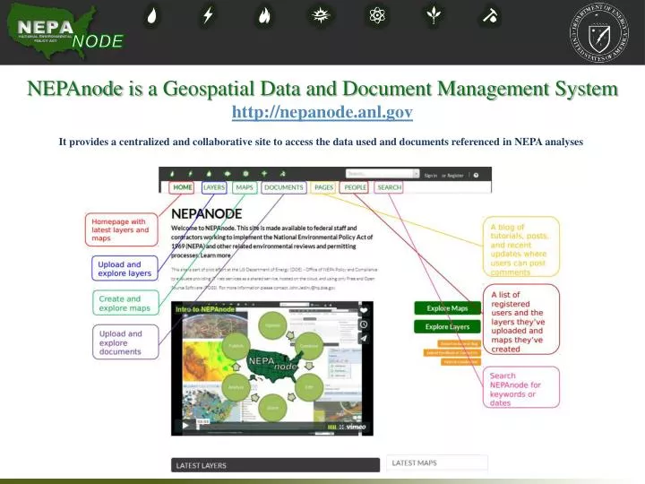
NEPAnode is a Geospatial Data and Document Management System http://nepanode.anl.gov It provides a centralized and collaborative site to access the data used and documents referenced in NEPA analyses
What is NEPAnode? Static Spectrum of Data Formats Service ShapefilesVector GeotiffRaster CSV Lat/Long Web Map Tiling Services (WMTS) Site Surveys Engineering Documents and Blueprints Web Mapping Services (WMS) Static Geographic Data (Spatial Data) Web Feature Services (WFS) Historical Maps Web Coverage Services (WCS) Zoning Maps Geographic Data Services MapWarper Geo-Referenced Documents (Non-Spatial Data) NODE Desktop Integration (WFS-T) Create Web Maps
NEPAnode: Overview of Features • Entire Software Stack is Open Source (GPLv3) • Upload, style, edit, and collaborate on geographic data with other agencies, stakeholders directly from the web browser • Project specific data (e.g. site maps, surveys,studies, engineering designs, etc.) • Reference data • Combine uploaded layers together with external data services (WMS/WMTS/GeoRSS) • Save the layer combination as a “map” for focused visualization and sharing • Manage map content and share on any other web site • Download the data, or link to it as a data and metadata service/feed through Open Standard interfaces and formats • Upload, share, and link maps to documents (.pdf,.doc,.xls, etc.) • Access shared layer library (60 currently)
Integrating the Best of Both DOE InvestmentsNEPAnode EISPC Energy Zone Mapper http://nepanode.anl.gov http://eispc.anl.gov • Developed over 60 siting models for 25 types of power generation technologies. Data Management Webmaps Reports Modeling
NEPAnode: A Platform with the Future in Mind • Time Support • The software (Geonode) supports data with a temporal (time) element. This could be used to model past and future scenarios as a time lapse or video like functionality (Ex. www.mapstory.org) • Version Control • The software (Geonode) can integrate with GeoGit a version control system that tracks each edit and addition to a dataset. While GeoGit is still early in development, it may eventually enable us to better manage data history as well as roll back to previous versions of the data for comparison or to nullify deletions and mistakes similar in concept to edit -> undo on documents. • Analytical Tools (Modeling and Reporting) – EISPC Integration • Create new layers (point/line/polygon) directly within the map interface • Reports using user layers and cross-tabulation (i.e. comparison among alternatives) • Viewshed Modeling • Noise Attenuation Modeling • Clip and ship download of data by project area, map extent, or a user drawn polygon • Commonly-used GIS processing tools • Buffer, Intersect, Clip, etc. • Web-based Georeferencing of Static Images – MapWarper Integration • Crowdsourcing Data Collection and Review • Consultation Map – Create a single map containing Federal jurisdictions, regions, land ownership, permitting/review responsibilities, and contact information. • Georeferencing Past Environmental Documents CEQ NEPA IT Group Meeting - February 4, 2014