Download

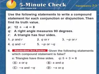
1 / 23
230 likes | 248 Views
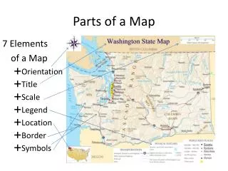
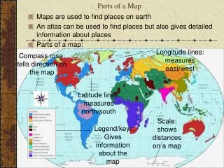
Parts of a Map SOL WG.1a. Parts of a Map. Most maps have the following elements, which are necessary to read and understand them See page 15. Title. The title explains the subject of the map and gives you an idea of what information the map conveys. Legend /Key.

E N D
Parts of a Map • Most maps have the following elements, which are necessary to read and understand them • See page 15
Title • The title explains the subject of the map and gives you an idea of what information the map conveys
Legend/Key • A legend or key lists and explains the symbols and use of color on the map
Symbols • Symbols represent items such as capital cities, economic activities, or natural resources. Check the map legend for more details (Page 15)
Scale • Scale shows the ratio between a unit of length on the map and a unit of distance on the earth
Scale • Ratio Scale - Shows the distance on the map compared to real earth measurement (1 = 30,000,000, 1 = 500 miles) • Bar Scale - Shows the ratio of distance on the map to distance on the earth (Page 16)
Compass Rose • The compass rose shows you directions on a map • Cardinal directions are north, south, east, and west • Intermediate directions are northeast, northwest, southwest, and southeast
Grid System • Grid System—used to measure destinations on a map. • There are two main lines that make up the grid system: latitude and longitude. • Latitude and longitude lines are measured in degrees. • The symbol for degrees is __________. • When listing latitude and longitude you always list latitude first, then longitude. It should look like this: 45N, 62E. A comma goes between the two numbers.
Latitude and Longitude Finding your location throughout the world!
By combining latitude and longitude, any location can be pinpointed
ApplicationN W E S North America is in the Northern Hemisphere because it is north of the Equator. North America is in the Western Hemisphere because it is west of the Prime Meridian.
Lines of Latitude • These are imaginary lines that measure distance north or south of the equator and run from east to west on the map. • These lines are also called parallels because they do not touch.
The Equator • The equator is the longest of all lines of latitude • It divides the earth in half and is measured as 0° (Zero degrees).
Lines of Latitude • Some important lines of latitude are: • The Equator - 0° • The Tropic of Cancer - 23º 26’ N • The Tropic of Capricorn - 23º 26’ S • The Arctic Circle - 66° 33’ N • The Antarctic Circle - 66° 33’ S
There are 90 degrees of latitude from the equator to each of the poles, north and south. Latitude lines are parallel, that is they are the same distance apart These lines are sometimes refered to as parallels. What is Latitude
Lines of Longitude • These are imaginary lines that measure distance east or west of the prime meridian and run from north to south on the map. These lines connect at the north and south poles. These lines are also called meridians.
The Prime Meridian, as do all other lines of longitude, pass through the north and south pole. They make the earth look like a peeled orange. What is Longitude?
The Prime Meridian • The Prime meridian divides the earth in half too. • It is also 0°. It passes through the community of Greenwich, England.
Using Latitude and Longitude • To find your exact location on a map, you need to determine which latitude line and which longitude line meet where you are standing. • When writing locations, the latitude is given first. • For example • Miami, Florida, has a location of 25° North and 80° West. • This is usually written in a short form as 25° N 80° W
Give the Latitude and Longitude of each of the following shapes. Viking Ship________ Hurricane_________ Tourist___________ Rafter____________ Whale____________ Canoeists_________ Flying Bird_________ Lets Practice 15˚ N, 5˚W 10 ˚S, 5 ˚E 15 ˚N, 15˚E 25˚S, 10˚W 0 ˚, 5˚W 5 ˚S, 20˚E 25 ˚N ,5˚E