Download
1 / 67
730 likes | 1.13k Views
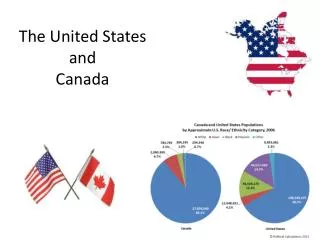
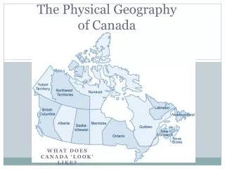
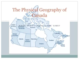
Physical Geography of the United States and Canada. Physical Map of North America. Basic Facts . Canada is the 2 nd largest country in the world The United States is the 3 rd largest country (Russia is the largest)

E N D
Basic Facts • Canada is the 2nd largest country in the world • The United States is the 3rd largest country • (Russia is the largest) • Extend from the Atlantic Ocean to the Pacific Ocean and from the Arctic Ocean to the Gulf of Mexico
Regions of North America This map can be found on page 118 in your text book!
Regions • The Eastern Lowlands (aka Gulf- Atlantic Coastal Plains) • Flat coastal plains that runs along the Atlantic and the Gulf of Mexico • Piedmont: low plateau between the Eastern Lowlands and the Appalachian mountains • Contains many fast-flowing rivers
Regions • The Interior Lowlands • Covers interior of North America • Flattened by glaciers • Interior plains • Great Plains • Canadian Shield
Regions • Appalachian Highlands • Green Mts. and Catskill Mts.= North • Blue Ridge and Great Smokey Mts. = South • Appalachian Trail = 2,160 miles long
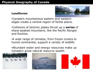
Regions • Western Mountains, Plateaus, and Basins • Rocky Mountains • Continental Divide • Sierra Nevada • Cascade Range • North America’s highest peak = Mt. McKinley
Mountains • Appalachian Mountains • West of the coastal plain • 1,600 miles long from Newfoundland to Alabama • 400 million years old • 1,200 ft to 2,000 ft high • RockyMountains • Continental Divide • 3,000 miles (4,830 km) from British Columbia, Canada, to New Mexico, United States. • 80 million years old • 12,000 ft high
Landforms • The Islands • Ellesmere, Victoria, Baffin Islands • Aleutian Islands • Hawaiian Islands
Rivers • Mississippi River = longest in continent • Mackenzie River = Canada’s longest river • Colorado River= formed Grand Canyon
Great Lakes Formed by glaciers at the end of the last glacial period around 10,000 years ago
Resources • Both countries rich in natural resources: • Fertile soil • Ample water supply • Vast forests • Variety of minerals
Minerals and Fossil Fuels • Canada = iron ore, nickel, copper, gold, uranium • United States= Fishing, River transportation, salt • Both countries = coal, natural gas, oil, energy producing fossil fuels
Forests • 1/2 of Canada and 1/3 of the U.S. is covered by forests • North America is the world’s leading food exporter • Much of this agricultural land is found in the plains region and in river valleys
Shared Climates and Vegetation • Cold Climates • Tundra • Far North Canada/ Alaska • Near the Arctic Circle • Almost no vegetation • Subarctic • Arctic coast of Alaska and Canada • Very little vegetation if any • Winters = long and bitterly cold • Summers = brief and chilly • Highland • Rocky Mountains and Pacific Ranges • Coniferous forests
Shared Climates and Vegetation • Moderate Climates • Winters cold Summers Warm • Humid continental • North central/ northeastern U.S. and Southern Canada • Semi dry • Pacific west coast • Rainy • Prevailing Westerlies
Differences in Climate and Vegetation • Milder climates • Humid Subtropical • Summers hot and muggy • Winters mild and cool • Long growing season for variety of crops • Southern States
Differences in Climate and Vegetation • Dry Climates • Semiarid • Dry and mild temperatures • Short grasses/ srubs • Great Plains and northern part of Great Basin • Arid • Southwestern states • Very dry/ warm temperatures • Very little vegetation
Differences in Climate and Vegetation • Tropical Climates • Hawaii and Southern Florida • Florida Everglades • Hot, rainy climate
Extreme Weather • Air from the Gulf of Mexico ( warm and humid) clash with Canadian air (cold and dry • Blizzards in the North • Thunderstorms in the south • Great Plains= tornado ally
Settlement and Agriculture Alter the Land • First inhabitants were nomads; people who move from place to place • Beringia: land bridge that once connected Siberia and Alaska • they were hunters and gathers
Settlement Agriculture Alter the Land • Early settlements became permanent about 13,000 years ago • Agriculture • Included: corn, beans & squash • Changed the landscape to meet their needs • Dug ditches • Cut down trees to build houses/ fuel for fires.
Building Cities • Montreal, Quebec (1642): • Below freezing over 100 days of the year • Canada’s 2nd largest city and a major port • Includes underground shops & restaurants • Los Angeles: 2nd most populous city in U.S. • Very mild climate all year round • Rapid growth forced people into nearby valleys and desert-like foothills. • The city itself is only 469 square miles however the metropolitan area spreads over 4,060 square miles • With rapid growth and high population came
Overcoming Distances • Trails and Inland Waterways • St. Lawrence Seaway: N.A.’s most important deepwater ship route • Connects Great Lakes to Atlantic • Oregon and Santa Fe trails 1800’s
Overcoming Distances • Transcontinental Railroads • 1st one completed in U.S. in 1869 • Trans-Canada railroad completed in 1885
Overcoming Distances • National Highway Systems • Trans-Canada Highway • U.S. interstate system is a network of more than 46,000 miles of highway
History • Original settlers around 13,000 years ago. • Called Nomads • The women learned to grows crops, harvest them and prepare the food to eat. • Women would also gather berries, wild plants, leaves and roots for medicine. • Spanish settlers came during the 1500’s • “New World” • St. Augusta, Florida
History • French • 1600’s • Northern Atlantic Coast near St. Lawrence River • English • 1600’s • Maine to Georgia • 1607 Jamestown, Virginia
History • In 1617 European colonies brought over Africans to work the cotton and tobacco plantations as slave laborers. • This was the start of the Columbian Exchange. • American Revolution (1775-1783) • Louisiana Purchase (1803)
Government • Constitution • Representative democracy • Federal republic • Three Branches • Executive, Legislative, Judicial • States government
The World’s Greatest Economic Power • The U.S. has about 7% of the world’s land area and 5% of the world’ population • The U.S. is a world leader in: • Agricultural products • Manufactured goods • Global trade (10% of world’s exports)
The World’s Greatest Economic Power • Three factors contribute to overall success of the American economy: • Available natural resources • Skilled labor force • Stable political system • Economy is run on a free enterprise system
FREE ENTERPRISE VS COMMUNISM FREE ENTERPRISE INDIVIDUALS MAKE DECISIONS ON BUYING AND SELLING HIGHER STANDARD OF LIVING COMMUNISM CENTRAL GOVERNMENT MAKES DECISIONS MIXED STANDARD OF LIVING
Agriculture • American farms and ranches supply about: • 40% of corn • 20% of cotton • 10% of wheat, cattle, hogs
Industry • Leading industries include: • Petroleum • Steel • Transportation equipment • Chemicals • Food processing • Telecommunications • Electronics
Post Industrial Economy • Service Industry: any kind of economic activity that produces a service rather than a product • Ex. Restaurant, hotel • Postindustrial Economy: manufacturing no longer plays a dominant role • Multinationals: corporations that engage in worldwide business
A Diverse Society • 70% trace ancestry to Europe • 13% trace ancestry from Central and South America • 12% trace ancestry to Africa • 4% trace ancestry to Asia • 1% are Native Americans • A map can be seen on page 142 in text book
Language and Religion • English Language is dominant language • Spanish is 2nd • 1,000 different religious groups in the U.S. • 56% = Protestants • 28% = Roman Catholics • 2% = Jewish • 2% = Muslim
The Arts and Popular Culture • Truly American styles began to develop in the 19th century in: • Painting • Music • Literature • Architecture • skyscraper
History and Government of Canada (1) • Like the United States, people migrated across Beringia into Canada, these people were the ancestors of the Inuit (Eskimos) • 16th and 17th centuries, French claimed most of Canada • French and Indian War (1754-1763)- war over lands in North America
Land split between Catholic and Protestant • Upper Canada had a English speaking majority (Great Lakes) • Lower Canada had a French speaking population (Quebec, St. Lawrence River) • 1867- Dominion of Canada was created to be a loose confederation (political union of Upper and Lower Canada) • 1871- Canada stretched from the Atlantic to the Pacific
With this stretch of land, what had to be developed in order to have successful settlement?