Download
1 / 1
10 likes | 268 Views
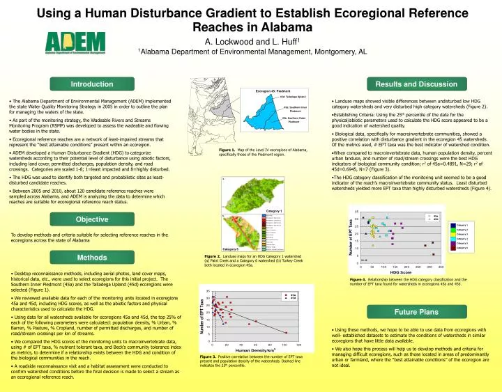
a. Ecoregion 45: Piedmont. 45d: Talladega Upland. Category 1. Category 2. Category 3. Category 4. 45a: Southern Inner Piedmont. Category 1. Category 5. Category 6. b. 45b: Southern Outer Piedmont. N= 36. Category 6. Methods. Objective. Introduction. Future Plans.

E N D
a. Ecoregion 45: Piedmont 45d: Talladega Upland Category 1 Category 2 Category 3 Category 4 45a: Southern Inner Piedmont Category 1 Category 5 Category 6 b. 45b: Southern Outer Piedmont N= 36 Category 6 Methods Objective Introduction Future Plans Results and Discussion Figure 2. Landuse maps for an HDG Category 1 watershed (a) Paint Creek and a Category 6 watershed (b) Turkey Creek both located in ecoregion 45a. Figure 3. Positive correlation between the number of EPT taxa present and population density of the watersheds.Dashed line indicates the 25th percentile. Using a Human Disturbance Gradient to Establish Ecoregional Reference Reaches in Alabama A. Lockwood and L. Huff1 1Alabama Department of Environmental Management, Montgomery, AL • The Alabama Department of Environmental Management (ADEM) implemented the state Water Quality Monitoring Strategy in 2005 in order to outline the plan for managing the waters of the state. • As part of the monitoring strategy, the Wadeable Rivers and Streams Monitoring Program (RSMP) was developed to assess the wadeable and flowing water bodies in the state. • Ecoregional reference reaches are a network of least-impaired streams that represent the “best attainable conditions” present within an ecoregion. • ADEM developed a Human Disturbance Gradient (HDG) to categorize watersheds according to their potential level of disturbance using abiotic factors, including land cover, permitted discharges, population density, and road crossings. Categories are scaled 1-8; 1=least impacted and 8=highly disturbed. • The HDG was used to identify both targeted and probabilistic sites as least-disturbed candidate reaches. • Between 2005 and 2010, about 120 candidate reference reaches were sampled across Alabama, and ADEM is analyzing the data to determine which reaches are suitable for ecoregional reference reach status. • Landuse maps showed visible differences between undisturbed low HDG category watersheds and very disturbed high category watersheds (Figure 2). • Establishing Criteria: Using the 25th percentile of the data for the physical/abiotic parameters used to calculate the HDG score appeared to be a good indication of watershed quality. • Biological data, specifically for macroinvertebrate communities, showed a positive correlation with disturbance gradient in the ecoregion 45 watersheds. Of the metrics used, # EPT taxa was the best indicator of watershed condition. • When compared to macroinvertebrate data, human population density, percent urban landuse, and number of road/stream crossings were the best HDG indicators of biological community condition; r2 of 45a=0.4891, N=29; r2 of 45d=0.6945, N=7 (Figure 3). • The HDG category classification of the monitoring unit seemed to be a good indicator of the reach’s macroinvertebrate community status. Least disturbed watersheds yielded more EPT taxa than highly disturbed watersheds (Figure 4). Figure 1. Map of the Level IV ecoregions of Alabama, specifically those of the Piedmont region. To develop methods and criteria suitable for selecting reference reaches in the ecoregions across the state of Alabama • Desktop reconnaissance methods, including aerial photos, land cover maps, historical data, etc., were used to select ecoregions for this initial project. The Southern Inner Piedmont (45a) and the Talladega Upland (45d) ecoregions were selected (Figure 1). • We reviewed available data for each of the monitoring units located in ecoregions 45a and 45d, including HDG scores, as well as the abiotic factors and physical characteristics used to calculate the HDG. • Using data for all watersheds available for ecoregions 45a and 45d, the top 25% of each of the following parameters were calculated: population density, % Urban, % Barren, % Pasture, % Cropland, number of permitted discharges, and number of road/stream crossings per km of streams. • We compared the HDG scores of the monitoring units to macroinvertebrate data, using # of EPT taxa, % nutrient tolerant taxa, and Beck’s community tolerance index as metrics, to determine if a relationship exists between the HDG and condition of the biological communities in the reach. • A roadside reconnaissance visit and a habitat assessment were conducted to confirm watershed conditions before the final decision is made to select a stream as an ecoregional reference reach. Figure 4. Relationship between the HDG category classification and the number of EPT taxa found for watersheds in ecoregions 45a and 45d. • Using these methods, we hope to be able to use data from ecoregions with well- established datasets to estimate the conditions of watersheds in similar ecoregions that have little data available. • We also hope this process will help us to develop methods and criteria for managing difficult ecoregions, such as those located in areas of predominantly urban or farmland, where the “best attainable conditions” of the ecoregion are not ideal.