Download
1 / 28
280 likes | 402 Views
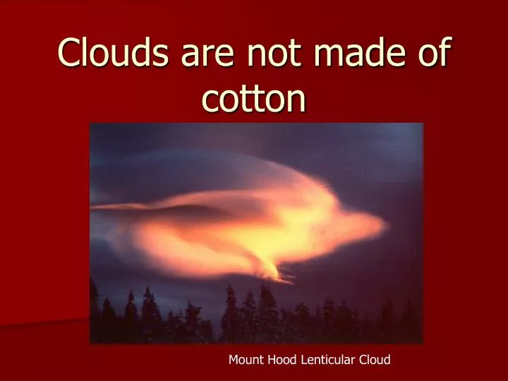
Clouds are not made of cotton. Mount Hood Lenticular Cloud. General Cloud terms. Cloud Classification. Further classification identifies clouds by height of cloud base.

E N D
Clouds are not made of cotton Mount Hood Lenticular Cloud
Cloud Classification • Further classification identifies clouds by height of cloud base. • For example, cloud names containing the prefix "cirr-", as in cirrus clouds, are located at high levels while cloud names with the prefix "alto-", as in altostratus, are found at middle levels. This module introduces several cloud groups. • The first three groups are identified based upon their height above the ground. The fourth group consists of vertically developed clouds, while the final group consists of a collection of miscellaneous cloud types.
Cloud Classifications • High clouds - have bases above 18,000 feet • Middle clouds - have bases between 7,000 and 18,000 feet • Low clouds - have bases below 7,000 feet • Fog - cloud in contact with the ground • Multi-level clouds... vertically thick spanning multiple layers • Miscellaneous clouds: Example: orographic clouds - distinct clouds that form via interaction between wind and mountainous terrain features
High Level Clouds:High-level clouds form above 18,000 feet (6,000 meters) and since the temperatures are so cold at such high elevations, these clouds are primarily composed of ice crystals. High-level clouds are typically thin and white in appearance, but can appear in a magnificent array of colors when the sun is low on the horizon.
Cirrus Clouds: thin and wispy The most common form of high-level clouds are thin and often wispy cirrus clouds. Typically found at heights greater than 20,000 feet (6,000 meters), cirrus clouds are composed of ice crystals that originate from the freezing of supercooled water droplets. Cirrus generally occur in fair weather and point in the direction of air movement at their elevation.
Cirrocumulus Ice clouds. Precipitation possible within 15 to 20 hours if wind is steady from NE to S. Early summer A.M. could mean afternoon thundershowers. Other winds could bring overcast.
Cirrostratus Precipitation possible within 15 to 24 hours if wind is steady from NE E to S. Prismatic effect of sun or moon through ice crystals cause halo.
Mid-Level Clouds The bases of mid-level clouds typically appear between 6,500 to 18,000 feet (2,000 to 6,000 meters). Because of their lower altitudes, they are composed primarily of water droplets, however, they can also be composed of ice crystals when temperatures are cold enough.
Altocumulus Clouds parallel bands or rounded masses Altocumulus may appear as parallel bands (top photograph) or rounded masses (bottom photograph). Typically a portion of an altocumulus cloud is shaded, a characteristic which makes them distinguishable from the high-level cirrocumulus. Altocumulus clouds usually form by convection in an unstable layer aloft, which may result from the gradual lifting of air in advance of a cold front. The presence of altocumulus clouds on a warm and humid summer morning is commonly followed by thunderstorms later in the day.
Altocumulus Water and ice clouds. Some precipitation possible within 15 to 20 hours if wind steady from NE to S. Other winds could bring overcast sky.
Altostratus Precipitation possible within 10 to 20 hours if wind is steady from NE to S. Sun appears as if behind frosted glass. Other winds could bring overcast sky.
Low-Level Clouds Low clouds are of mostly composed of water droplets since their bases generally lie below 6,500 feet (2,000 meters). However, when temperatures are cold enough, these clouds may also contain ice particles and snow.
Nimbostratus Clouds dark, low-level clouds with precipitation Nimbostratus are dark, low-level clouds accompanied by light to moderately falling precipitation. Low clouds are primarily composed of water droplets since their bases generally lie below 6,500 feet (2,000 meters). However, when temperatures are cold enough, these clouds may also contain ice particles and snow.
Stratocumulus The State College Mascot Low water clouds of dark red color. Precipitation possible in 12 to 20 hours if winds from NE to S. Other winds may bring an overcast sky. Immediate threat of bad weather from a sprinkle to heavy precipitation. If head of a cold front, gusty winds or thunder showers.
Fog can be considered as a low stratus cloud in contact with the ground. When the fog lifts, it usually becomes true stratus.
Vertically Developed Clouds Probably the most familiar of the classified clouds is the cumulus cloud. Generated most commonly through either thermal convection or frontal lifting, these clouds can grow to heights in excess of 39,000 feet (12,000 meters), releasing incredible amounts of energy through the condensation of water vapor within the cloud itself.
Fair Weather Cumulus Clouds : puffy cotton balls floating in the sky Fair weather cumulus have the appearance of floating cotton and have a lifetime of 5-40 minutes. Known for their flat bases and distinct outlines, fair weather cumulus exhibit only slight vertical growth, with the cloud tops designating the limit of the rising air. Given suitable conditions, however, harmless fair weather cumulus can later develop into towering cumulonimbus clouds associated with powerful thunderstorms.
Fair weather cumulus are fueled by buoyant bubbles of air, or thermals, that rise upward from the earth's surface. As they rise, the water vapor within cools and condenses forming cloud droplets. Young fair weather cumulus have sharply defined edges and bases while the edges of older clouds appear more ragged, an artifact of cloud erosion. Evaporation along the cloud edges cools the surrounding air, making it heavier and producing sinking motion (or subsidence) outside the cloud. Wasatch Mountains, Salt Lake City, UT
Cumulonimbus Precipitation likely and soon, coming usually from SW W to N. Distant clouds often show an anvil-shaped cirroform cap.
Above: Towering Cu from the side Right: High Res Satellite Image of Cumulonimbus clouds.
Very rarely (less than 3% of the time) t-storm produces tornado Above: Various Tornadoes from NOAA website Left and Right: Not really a good Idea….
“Mammatus" clouds because they resemble the mammary glands of mammals. They indicate that the atmosphere is quite unstable and can also be an indicator of impending severe weather.
Other Random Clouds: Cap clouds form when air containing water vapor is uplifted on the windward slide of the slope and reaches saturation producing liquid water cloud droplets and a cloud which can "cap" the summit.
Lenticular clouds are lens-shaped clouds that can result from strong wind flow over rugged terrain. At the time of this photo, the winds were blowing around 30-40 mph from right to left, forming several lenticular clouds. Sometimes they stack up like pancakes in multiple layers
Another type of cloud can be formed from the vapor contained in the exhaust of a jet engine of an airplane when they are flying at high enough altitudes where cold temperatures cause the vapor to turn into ice crystals like cirrus clouds. These clouds are called "contrails" (short for "condensation trails") and look like lines in the sky.