Download
1 / 26
260 likes | 469 Views
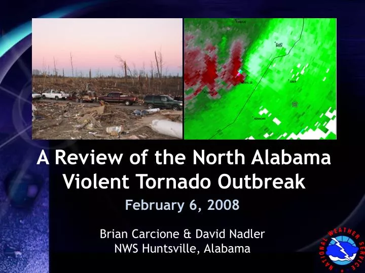
A Review of the North Alabama Violent Tornado Outbreak. February 6, 2008. Brian Carcione & David Nadler NWS Huntsville, Alabama. Overview. Modified version of presentation given to 7 th Annual Southeast Severe Storms Symposium

E N D
A Review of the North Alabama Violent Tornado Outbreak February 6, 2008 Brian Carcione & David Nadler NWS Huntsville, Alabama
Overview • Modified version of presentation given to 7th Annual Southeast Severe Storms Symposium • Focus on warning decision-making (warning forecaster’s perspective) • NWS NEXRAD Data • ARMOR Data • LMA in AWIPS and LMA trends • Food for thought/points for discussion
Local Event Overview No additional tornado damagein Tennessee EF-4 3:00 to 3:20 AM EF-1 EF-45:17 to 5:34 AM EF-14:43 AM EF-1 EF-04:00 AM EF-2 EF-0 “Storm Track Map” – MESH Data from NSSL
09 & 11Z UTC SPC Mesoanalysis 0-1km SRH & Storm Motion MLCAPE (contour) & MLCIN (shaded)
Storm-scale / Radar Analysis 0600-1100UTC 06 Feb 2008 Radar Mosaic
KGWX 0.5_1.3° BR/SRM - 0859Z 06 Feb Lawrence County Tornado EF-4 tornado touching down around this time KGWX 0.5° base velocity 100+ kt KGWX: 62nm away, 0.5° angle elevation ~5700ft AGL
KHTX 0.5_1.3° BR/SRM - 0906Z 06 Feb Lawrence County Tornado Rotational Velocity 109kt (81kt outbound, 28kt inbound) VR Shear = .0267 s-1 KHTX: 65nm away, 0.5° angle elevation ~7400ft AGL
UAH ARMOR Data – 0848-0907Z 06 FebData interrogated & visualized with GR2Analyst 81kt rotational velocity 0.7° Base Reflectivity and Velocity ARMOR: 25-40nm away, 0.7° angle elevation ~2220-2970’ AGL
UAH ARMOR Data – 0912-0915Z 06 Feb 99kt Base Velocity at 1700’ AGL 0.7° Base Reflectivity and Velocity ARMOR: 20-30nm away, 0.7° angle elevation ~1600-2000ft AGL
LMA Data w/ KHTX Refl/SRM & LRM Lawrence County Storm - 0840Z Feb06 2008 Max source density ~ 36 as storm enters SW Lawrence County No tornado reported at this time
LMA Data w/ KHTX Refl/SRM & LRM Lawrence County Storm - 0856Z Feb06 2008 Source density jumps to ~ 61
LMA Data w/ KHTX Refl/SRM & LRM Lawrence County Storm - 0902Z Feb06 2008 Slight decrease in source density Tornado reported on the ground
LMA Data w/ KHTX Refl/SRM & LRM Lawrence County Storm - 0906Z Feb06 2008 4 minutes later, source density diminishes significantly Tornado still on the ground
Supercell-squall line merger EF-4 Tornado
KHTX 0.5_1.3° BR/SRM - 1043Z 06 Feb Jackson County Tornado Brief EF-1 touchdown just north of Guntersville, AL
KHTX 0.5_1.3° BR/SRM - 1115Z 06 Feb Jackson County Tornado
KHTX 0.5_1.3° BR/SRM - 1125Z 06 Feb Jackson County Tornado Rotational Velocity 132kts at ~ 1500ft AGL (70kt inbound, 62kt outbound) Enhanced reflectivity indicates possible debris detection
UAH ARMOR Data – 1118-1119Z 06 Feb 84kt velocity 87kt rotational velocity at 3680’ AGL 0.7° Base Reflectivity and Velocity ARMOR: ~45nm away, 0.7° angle elevation ~3700-4600ft AGL
LMA Data w/ KHTX Refl/SRM & LRM Jackson County Storm - 1032Z Feb06 2008 Max source density ~ 105 No tornado reports yet
LMA Data w/ KHTX Refl/SRM & LRM Jackson County Storm - 1038Z Feb06 2008 Significant decrease within 6 minutes Reflectivity suggests a more ‘classic’ supercell structure with more impressive updrafts EF-1 Tornado on the ground
LMA Data w/ KHTX Refl/SRM & LRM Jackson County Storm - 1100Z Feb06 2008 Big jump as storm ascends Sand Mountain Reflectivity diminishing, perhaps becoming a lower-topped supercell No tornado on the ground at this time
LMA Data w/ KHTX Refl/SRM & LRM Jackson County Storm - 1125Z Feb06 2008 Enhanced “white” area possible debris being detected by 88D base reflectivity Storm begins to weaken, supported by significant flash decrease EF-4 Tornado on the ground
Ascending Sand Mountain EF-1 near Guntersville EF-4 Tornado
Food for Thought: ARMOR • ARMOR samples most of the ‘central’ HUN CWFA better than any NWS NEXRAD • Would have been more useful to ascertain reflectivity structure • Has some unique limitations • Many forecasters are eager to use and learn about the ARMOR data • GR2Analyst makes it more readily available • Dual-pol upgrade will make that data more accessable as well • COMET partnership to make data available in AWIPS will be a key
Food for Thought: LMA • Tertiary data source during this event—radars, reports, upstream conditions, etc. were of greater importance • HUN forecasters traditionally look for jumps/drops in LMA data based on earlier research (~2001-2004) • This case does not disprove that, but does show weaknesses in an overly-simplistic methodology • Cool season vs. warm season environments—not all storms are created equal • Distance/sampling concerns similar to those with radar data • Difficulty in visualizing & analyzing LMA data (trends, color tables, etc.) • More research, better visualization techniques, training refreshers will help
Questions or Comments? Brian.Carcione@noaa.gov David.Nadler@noaa.gov http://weather.gov/huntsville Thanks to Chris Darden and our NASA and UAH partners