Download
1 / 17
170 likes | 276 Views
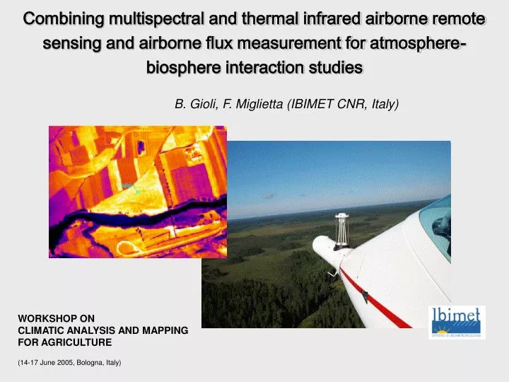
Combining multispectral and thermal infrared airborne remote sensing and airborne flux measurement for atmosphere-biosphere interaction studies. B. Gioli, F. Miglietta (IBIMET CNR, Italy). WORKSHOP ON CLIMATIC ANALYSIS AND MAPPING FOR AGRICULTURE (14-17 June 2005, Bologna, Italy). Summary:

E N D
Combining multispectral and thermal infrared airborne remote sensing and airborne flux measurement for atmosphere-biosphere interaction studies B. Gioli, F. Miglietta (IBIMET CNR, Italy) WORKSHOP ON CLIMATIC ANALYSIS AND MAPPING FOR AGRICULTURE (14-17 June 2005, Bologna, Italy)
Summary: SKYARROW ERA PLATFORM Airborne eddy covariance flux measurements Airborne IR and multispectral remote sensing PRODUCTS Surface fluxes at the regional scale Vegetation indexes and surface temperature maps APPLICATIONS Multispectral remote sensing coupled with CO2 fluxes IR remote sensing coupled with sensible heat fluxes CONCLUSIONS
Net Radiation PAR Radiation Attitude GPS Novatel GPS GPS Electronics Switch BOX IRGA Pressure Sphere T Fast Response T Low Response Sky Arrow ERA IR camera Multispectral camera Laser altimeter
The platform: NOAA Mobile Flux Platform (MFP) Measurement of 3D winds @ 50 Hz CO2, H2O, T fast sensors
The platform: Airborne Digital Mapping System - DFR DFR is a digital multispectral remote sensing system (3 CIR and 1 thermal bands) for mapping, thermography, maps of temperature and water monitoring. Multispectral Digital Camera Duncan MS 4100 3 band - 550 (Green), 680 (Red), 780 (NIR) nm Dicroic Prisma 3CCD 1920 x 1080 Flir IR SC500 Camera Spectral range 7500 – 13000 nm CCD 320 x 240 microbolometer Range fighter Riegl LD90 e LD90-3300HR Measure range (without reflector) 1000 m - 100 Hz GPS attitude 4 antennas Measure of position and attitude Trigger to synchronize the acquisition of instruments Industrial PC
The products 3D wind + scalar (T, H2O, CO2) fast measurements (50 Hz) (eddy covariance tecnique) Surface fluxes along flight track (u*, H, LE, fCO2)
The products Multispectral images to derive vegetation indexes NDVI = (IR-Rd) / (IR+Rd) IR images to derive surface temperature maps
The projects: • RECAB: (European Commission, V FP) 2001-2003 • CARBIUS ((Italy and USA Gov.) 2003-2005 • CarboEurope IP (European Commission, VI FP) 2004-2008
Wind direction Aircraft track 3Km NDVI of the footprint area The goal: upscale directly measured airborne fluxes along a track to the region x90
Applications: NDVI Vs fCO2 • Airborne remote sensing (NDVI) • Surface flux measurements • Vertical PBL profiles
NDVI • Flight route
Cropland Forest Applications: NDVI Vs fCO2 NDVI C-flux (umol m-2 s-1) LON
CO2 flux NDVI Applications: NDVI Vs fCO2
Applications: Tsfc Vs H & LE Bulk formulation of sensible heat flux • rcp is the volumetric heat capacity • T0 is the aerodynamic temperature at canopy source/sink height • Ta is air temperature • ra is the atmospheric resistance between canopy source/sink height and the • ambient environment above the canopy Use Tsfc to estimate T0 in the flux footprint area Use direct H measurements to parametrize ra Apply parametrization at regional scale
Applications: Tsfc Vs H & LE • Experimental strategy • 1 aircraft measuring surface fluxes and Tsfc over a small footprint • 2 aircraft measuring surface fluxes and Tsfc in the entire flux footprint Tsfc from IR images H, LE direct measurement
Applications: Tsfc Vs H & LE • Rice and lake areas, Spain • Evergreen forest, The Netherlands
Conclusions • Airborne eddy covariance is a valuable tool for direct surface flux measurements at the regional scale • Airborne remote sensing within the flux footprint area has been used to develop upscale schemes • Potential for using satellite products to further bridge the gap between local airborne measurements and complete coverage • Acknowledgments: • RECAB, 2001-2003 (European Commission, V FP) • CARBIUS (2003-2005) • (Ministero Ambiente e Territorio) • CarboEurope IP (2004-2008) • (European Commission, VI FP)