Download
1 / 66
700 likes | 1.04k Views
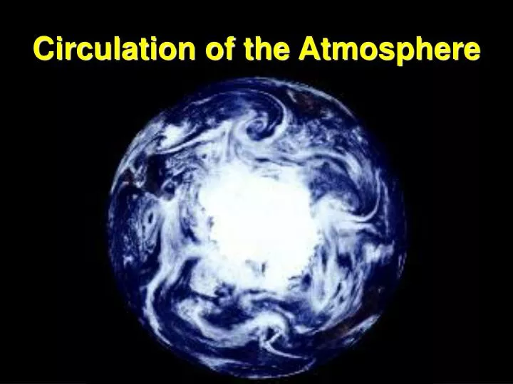
Circulation of the Atmosphere. A. Scales of Atmospheric Motion. Winds are classified according to the size of the system and the time frame in which they occur. Large- and Small-Scale Circulation. a. Macroscale Winds : The largest wind patterns. Planetary. weeks or longer.

E N D
A. Scales of Atmospheric Motion Winds are classified according to the size of the system and the time frame in which they occur.
a. Macroscale Winds: The largest wind patterns Planetary weeks or longer • __________Scale Winds: • Last _________________ • Can extend the entire globe (1,000 to 40,000 km • Examples are the westerlies and trade winds. Trade Winds
(2) ___________ Scale Winds (Also called weather-map winds) Synoptic • Last ______________ • Have horizontal dimensions of 100 to 5,000 km • Well-known examples include: days to weeks
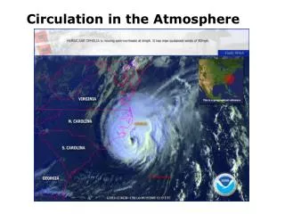
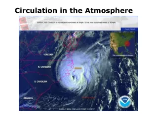
Hurricanes Hurricane Nora Sept. 22, 1997
b. Mesoscale Winds • Have a strong ________component • Last for ___________________________ __________. (3) Are usually less than 100 km across. (4) Include: vertical several minutes and may exist for hours.
Tornadoes Greensburg, KS on May 5, 2007
c. Microscale Winds (1) ________scale air motion (less than 1 km) (2) Last for seconds or at most a few minutes • Include: (a) Simple Gusts Smallest
(b) Dust Devils Arizona • Form on clear days unlike tornadoes that are associated with convective clouds • Form from the ground upward • Unstable air rises • Rotation increases due to conservation of angular momentum. • As air rises it carries sand, dust, and other loose debris dozens of meters into the air. • Can be undetected over vegetated surfaces.
Dust Devils on Mars • 10 times larger than any tornado on Earth • Kilometers high and 100’s of meters wide • Wind speeds: 30 m/sec (70 mi/hr) 05/15/2005 Credit: Mars rover Spirit
2. Structure of Wind Patterns a. Global winds are a composite of all ________________. b. This is analogous to a meandering river whose current flows consistently in _____direction but contains many large _______ (swirling currents) which may contain even smaller eddies. scales of motion one eddies
c. Flow associated with hurricanes is an example. (1) From space hurricanes appear as a large whirling cloud moving slowly across the ocean.
(2) Hurricanes often have a net motion from __________ indicating that they are larger eddies embedded in a larger macroscale flow. east to west
(3) Hurricanes have several scales of motion. • Mesoscale thunderstorms and tornadoes • Microscale disturbances are imbedded in the mesoscale motions. • The counterclockwise synoptic scale flow is imbedded in the larger-scale planetary winds (_________ and ____________). trades westerlies westerlies Trades
B. Local Winds 1. Land and Sea Breezes: Caused by daily temperature contrast between land and water
a. Sea Breeze During the Day By Mid-Afternoon H L Sea Breeze (Develops during the day) Warmer, Less dense air Cooler, Denser Air Land Water Land heats faster and is warmer Water heats slower than the land and is cooler
b. Land Breeze at Night The reverse of the sea breeze forms after sunset L H Land Breeze (Develops at night) Cooler, denser air Warmer, Less dense Air Land Water Land cools faster and is cooler Water cools slower than the land and is warmer
2. Mountain and Valley Breezes • _____________ Breeze (1) Heating during the day causes air______. (2) Also referred to as ________. (3) Often recognized cloud development on mountain peaks. Valley rise thermals
Valley Breeze • Cloud development on mountain peaks from a daytime upslope (valley) breeze • Can develop into mid-afternoon thunderstorms
b. ________ Breeze Mountain • __________at night • ________air drains into the valley Cooling Denser
3. Chinook (Foehn) Winds • Strong downslope winds from mountains. • Caused by a significant difference in pressure on the windward side vs. the leeward side. • Air rises, and cools on the windward side and then heats due to compression as it descends on the leeward side • Can cause a temperature increase of 10 to 20 degrees Celsius in a matter of minutes. • Common in the Rockies (where they are called chinooks meaning snow-eater) and the Alps (where they are called (foehns).
4. Santa Ana Wind • A chinook-like wind that occurs when a strong high pressure system settles to the NE of southern California with low pressure to the SW. Clockwise flow forces desert air from Arizona and Nevada westward towards the Pacific. It is funneled through the canyons of the Coast Ranges, compresses and heat the region to temperatures that can exceed 100 degrees F.
5. Katabatic or Fall Winds • Cold and dense air cascades over a highland area. • The air does heat as it sinks but it’s still colder than the air it displaces due to its very cold original temperature. • Occurs on ice sheets of Greenland and Antarctica.
Called a mistral from the French Alps to the Mediteranean Sea
Called a bora from the mountains of Yugoslavia to the Adriatic Sea
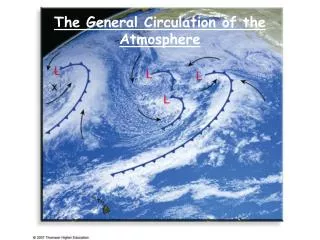
The General Circulation of the Atmosphere • Large Scale Air Flow - Caused by: • ___________________by the Sun resulting in pressure differences. • Earth’s _________________________ Unequal heating rotation (the Coriolis Effect)
2. A Nonrotating Earth • A simple convection system produced by unequal heating. • Greatest heating in________________ region • Polar regions __________________ • Convection cell model first proposed by George Hadley in 1735 Equatorial coldest
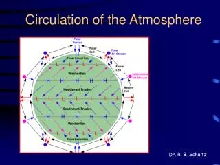
3. The Three Cell Model for the__________Earth rotating a. Accounts for the maintenance of Earth’s heat balance and conservation of angular momentum
b.Tropical Hadley Cell (0o to 30o latitude) • Near the equator warm air rises and releases latent heat and upper flow moves poleward • Upper flow starts to descend between 20o and 35o latitude due to (1) radiational cooling and (2) increased Coriolis effect causing deflection to nearly west to east flow. This causes convergence H L Hadley Cells (3)At the surface a region of higher pressure exists at about 30o latitude. These are referred to as the horse latitudes due to the generally weak and variable winds. (4) Air flows towards the equator. This equatorward flow is deflected by the Coriolis effect forming the trade winds
At the equator there is a weak pressure gradient with light winds and humid conditions. 5. Doldrums H L Hadley Cells
6. Intertropical Convergence Zone (ITCZ) ITCZ Z • The ITCZ is the equatorial region where the trade winds converge. • This region has rising, hot air with abundant precipitation
Satellite Image of the ITCZ ICTZ The ITCZ is seen as the band of clouds across the equatorial ocean and Central America
c. Ferrel Cell (mid-latitude indirect cell) Ferrel Cells • Not all the air that converges at around 30o North and South latitudes (at the subtropical high pressure zones) moves equatorward. Some moves towards higher latitudes. • Between 30o and 60o latitude the net surface flow is poleward. • The Coriolis force causes winds to have a strong westerly component resulting in the prevailing northwesterlies. (Aloft, due to cold polar air and warm tropical air the poleward directed pressure-gradient force is balanced by an equatorward-directed Coriolis force with the net result being a prevailing flow from east to west.)
d. Polar Cell Sinking Air L • Polar regions (from about 60o north and south) and extending to each pole. • Polar Easterlies: Prevailing winds are from the northeast in the Arctic and the southeast in the Antarctic. • Caused by the subsidence of cold dense air at the poles. • Eventually this cold polar air collides with the warmer westerly flow from the mid-latitudes resulting in the polar front.
Ideal Pressure Belts vs. The “Real World” • An imaginary uniform Earth with idealized, continuous pressure belts. • The real Earth with disruption of the zonal pattern caused by large landmasses. This causes the formation of semipermanent high and low pressure cells.
Semipermanent Pressure and Wind SystemsAverage Surface Pressure and Global Winds for January and July Note the change in the position of the ITCZ the semipermanent Highs
Average Surface Pressure and Global Winds for January • Polar Highs are prominent features of Northern Hemisphere winter circulation • Clear skies and divergent surface flow results from subsiding air resulting in the polar easterlies. • Siberian high • Strong high-pressure center position over northern Asia • Weak polar high • Over North America • Azores high • Subtropical high in the North Atlantic close to the northwest African coast
Average Surface Pressure and Global Winds for January • Semipermanent low-pressure centers (absent in July) • Aleutian and Icelandic lows • A composite of numerous cyclonic storms that move through these regions. So many cyclones are present that these regions almost always experience low pressure. • Cloudy conditions and abundant precipitation
Average Surface Pressure and Global Winds for July • Lows replace winter highs • Result from high surface temperatures over continents. • Warm air rises resulting in inward directed surface flow. • Strongest low develops over southern Asia • A weaker low is found in the southwestern United States.
Average Surface Pressure and Global Winds for July • Subtropical highs migrate westward become more intense than during the winter months. • Pump warm most air onto continents that are west of the highs • Increased precipitation oer parts of eastern North America and Southeast Asia results. • Bermuda High • The subtropical high found in the North Atlantic • During the winter it is found near Africa and is called the Azoores high.
D. Monsoons Seasonal (1) ____________ change in Earth’s global wind circulation. • Monsoon refers to a wind system that exhibits a pronounced seasonal __________________ not just a “rainy season.” A monsoon could result in a dry season reversal in direction
3. Summer Monsoon • Warm moist air blows ____________________________ • Results in abundant precipitation. • One of the world’s rainiest regions is found on the slopes of the Himalayas. • Rising moist air from the Indian Ocean cools. • Cherrapunji, India once had 25 m (82.5 ft.) of rain during a four-month period during the summer monsoon. Cherrapunji, India ITCZ migrates northward and draws warm Moist air onto the continent from the sea toward the land
4. Winter Monsoon • Winds ________________________. • Results in a _____winter In January a strong high pressure develops over Asia and cool, dry continental air causes the winter monsoon. blow off the continent dry