Download
1 / 26
260 likes | 356 Views
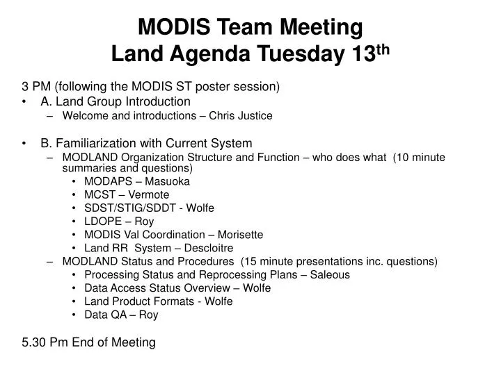
MODIS Team Meeting Land Agenda Tuesday 13 th. 3 PM (following the MODIS ST poster session) A. Land Group Introduction Welcome and introductions – Chris Justice B. Familiarization with Current System

E N D
MODIS Team Meeting Land Agenda Tuesday 13th 3 PM (following the MODIS ST poster session) • A. Land Group Introduction • Welcome and introductions – Chris Justice • B. Familiarization with Current System • MODLAND Organization Structure and Function – who does what (10 minute summaries and questions) • MODAPS – Masuoka • MCST – Vermote • SDST/STIG/SDDT - Wolfe • LDOPE – Roy • MODIS Val Coordination – Morisette • Land RR System – Descloitre • MODLAND Status and Procedures (15 minute presentations inc. questions) • Processing Status and Reprocessing Plans – Saleous • Data Access Status Overview – Wolfe • Land Product Formats - Wolfe • Data QA – Roy 5.30 Pm End of Meeting
MODIS Land Phase 2:welcome and introduction Land Discipline Chairman
Overview • Newly Reconstructed MODIS Land Team • Multiple Functions • Continued Product Generation, Algorithm Maintenance and Validation • ESE Science - incorporating MODIS into ESE science • Develop and Test New/improved Land products (presentations) • Plant Water Content, Evaporation, Improved Surface Reflectance • Contributing to Longer Term ‘community’ agenda – ‘stewardship’ • Establishing Suite of Mature MODIS Products • Refining data requirements • Quality assessment procedures • Establishing Validation Protocols • Consistent ‘Climate’ Data Records (MODIS > multi-instrument) (pres.) • Outreach to and feedback from the community of data users (presentations) • Guiding land data system development for Mod Resn processing • Secure Long Term archives of MODIS products • Transitioning MODIS capabilities and lessons to operational domain • MODIS to NPP and NPOESS VIIRS • MODIS intergrated in decision support • Contributing to the International observation coordination efforts • GOFC/GOLD, CEOS LPV, MEA, IGOS – IGOL – GEO (presentations)
Shifting MODLand Emphases Algorithm Development and Testing, Initial Coding Instrument Performance Evaluation – algorithm revision/recoding Product Testing and Beta Generation > Provisional Distribution Initial PR and Outreach / Code Revision First Reprocessing > Product QA and Validation Stage 1 Validated Product Distribution > Feedback Increased Outreach – User Feedback Refining Products to meet Science Needs Completion of Stage 2/3 Validation Expanded Science & Appl. Use Merge with Land Focus Teams Reprocessing (Collection 6) Instrument Deterioration? Current Emphases
MODLAND Core Group Organization Team Leader Atmospheres / Oceans • Land Discipline Chair - Justice • - Land team coordination • - Discipline trade offs • HQ interaction • GOFC/GOLD liaison SDST Leader - MasuokaMCST Leader - Xiong MODAPS Mgmnt SDST Management Calibration ESDIS interface • Land Production • Manager • - Saleous • Operations • Version Control • Collections • DAAC data flows • Validation Coordinator • - Morisette • Val Coordination • Aircraft Coordination • Other instruments • ORNL/EDC. Val data • CEOS LPV POC • QA Coordinator • - Roy • QA Metadata • Operational QA • Dependencies • ESDIS QA POC • QA Tools • SDDT Coordinator • - Wolfe • Geolocation • Code Developers • DAAC interface • SWGD POC Land Team Calibration POC. - Chang • Land Team Members and their Science Computing Facilities (SCF’s) • Code Development and Testing • Product Science QA and Validation • Instrument Performance/Calibration Monitoring • Science interface – beyond DAAC FAQs Rapid Response System - Descloitres - NRT Applications Users
MODLAND validation home pagehttp://modarch.gsfc.nasa.gov/MODIS/LAND/VAL Val Summaries EOS Core Sites Major Campaigns Val Metadata w. ORNL MODIS Validation Data sub sets w. EDC
Internal Communication Multiple interfaces to the Land Core Group requires regular and open communication with different project components – data, calibration, science • Weekly Tech Team Meetings with Team Leader • Weekly PI Processing Meetings with All Disciplines and DAACs • Weekly Calibration Meetings (Land Rep) • Bi weekly – Science Discipline Data Team (SDDT) Telecons • MODLAND/DAAC Telecons • Periodic MODLAND Discipline Meetings and Telecons • 6-12 month Science Team Meetings • Occasional SWGD Meetings and Telecons • WE CAN RESTRUCTURE AS NEEDED
External Communication Mechanisms • Initial IDS MODLAND Twinning (Land Team Members assigned to IDS) • Science Publications – special editions, etc. • IWG Presentations and Key Conferences e.g. AGU Sessions, IGARSS • MODLAND Program POC’s for Boreas/ LBA/ SAFARI/ NEESPI/ NACP? • Coordination with science/validation campaigns and scientists (cEOS Val) • Champion Science Users for feedback e.g. ECMWF, IDS PI’s, NEW ST • Champion Applications Users e.g. USFS, USDA • A growing land Direct Broadcast Community • Extensive Web Information Available • Each Product • QA, Validation, Developers • Developed Web-based Land Tools (QA etc ) to facilitate use (ESDIS supported) • Land Outreach Workshops • Posters / TV / Media / RR>Earth Observatory • International Outreach > contributing to GOS • Conferences and workshops • GOFC/GOLD Validation/User Regional Networks • MEA, FAO FRA, TCO • Int. Summits – WSSD, World Parks Congress, International Fire Summit • Education Outreach – videos, text books • EDC DAAC SAP Representation
Contributing to the emerging Land Focus Area • MODIS ST has been a major coordination focus for Land Mod Resn RS - helping make the case for a suite of land products (beyond NDVI) and building a number of structural land elements (Validation, GOFC/GOLD, Fluxnet, RR/DB) important for NPOESS • Continue strengthening the Land community • MODIS ST is one basis for broadening Land initiatives towards ‘measurements’ – getting the land community organized • Presentations on strategic issues – GEO-GOFC-IGOL, NPP, CDR’s etc • MODIS Workshops provide an opportunity to broaden community involvement – need to embrace more than MODIS • e.g. Montana LPV LAI inter-comparison session, NACP RS • Need to develop community consensusand understanding of what we are trying to do and a better understanding of what the community needs to do
MODIS Land Phase 2 • Land Products • Currently can distinguish between two types of product: • Standard products – fully automated, generated by MODIS Advanced Processing System (MODAPS), archived at the DAAC • Experimental products – generated by SCF’s, - interactive steps, distributed by SCF’s (exploring Distributed systems) • Product development continuing with Beta, Provisional, Validated (Stage 1, 2, 3) • New Products • Should be developed and tested on multiple granules at the SCF’s to at least Beta level • MODAPS Land Test System can be used for larger runs on new products – needs scheduling with Land SDST and STIG • Should not distribute products at DAAC until they are provisional or perhaps Stage 1 validated
Phase 2 MODIS Maintenance • Land Reprocessing • Collection 5 - Oct ‘04 delivery – code updates, bugs and revisions • Collection 5 will have increased emphasis on testing • Active program of product testing • ST members are welcome to be involved in the testing if they are willing • Land Data Operational Product Evaluation (LDOPE) group will continue to investigate dependencies • Collection 6 likely be the final major reprocessing (Late 05 delivery) and could/should include any new products • Collection 6 will likely follow a HQ directed review and decision re. priority data sets, long term archive of products • Reprocessing will likely continue in context of Mod Resolution LTDR
MODIS Phase 2 Cont’d • Validation (a maturing data and user community) • Ongoing Standard Products should be validated to Stage 2 – if appropriate suggest case for Stage 3 Validation be made at next product review • Need to keep land community focused and insisting on need for validated products (i.e. products of known accuracy) – CEOS LPV provides an international coordination mechanism (goal of global val. cost sharing) • More emphasis needed on team accuracy reporting • Need to establish community standards and protocols for validation – especially in light of NPP/NPOESS
MODIS Land Phase 2: greater community involvement • Continued Interaction with the Science Community and Outreach Needed • Land Web Sites • ATBD’s (review coming!) • User-guides • Propose workshops addressing community issues (Web Site Links) • Montana (MODIS Vegn/Val, LAI intercomp, NACP Remote Sensing -Presentation • EOS Snow Workshop, Greenbelt, Nov16/17 • Land DB MODIS>VIIRS 2005 (Justice) • GOFC/GOLD Workshops (Land Cover – Italy), (Fire – Russia, Chile, Australia), • Others ? • Continued interaction with the community on how to improve products and services (Discussion Session) • have the community help make the case for funding any new functionality • Increased interaction with the Modeling community (Discussion session) • Are improvements needed in formats, availability • Do we need another ‘Continuous Year Data Compillation • Etc
MODIS Land Phase 2 • MODIS Long Term Archive • NASA/USGS HQ in discussion – needs input from NASA science users, LTA advisory panel • Transitioning MODIS to Operational Domain • NOAA AVHRR land products serving NWS • Snow, VI, Vegetation Condition, Fire - No external review • NOAA currently generates L2 MODIS products using latest MODIS code and bent pipe – some MODIS products being distributed e.g. fire • Discussions on-going with ORA and NESDIS on generating MODIS products operationally – suggest a stronger link with the land team is needed (see Mitch Goldberg’s presentation) • Transitioning from MODIS to NPP • EDR’s being evaluated by the NPP ST • An NPP equivalent of Land MODAPS is being supported (PEATE) • NOAA claims it will generate CDR’s, NASA not yet committed to G/CDR’s (Breakout session) • MODIS lessons learned need to be clearly stated
Broad Community Peer Review • Review new / improved products after 2-3 years • Should be prior to end of 05 to make Collection 6 • Review of current products (within 1-3 years) • Assess quality and importance of data product suites • Prioritize EOS data products relative to community needs • Changes / improvements, • Data system service review (?) - level of service and archives • Land Group needs to articulate compelling justification for the Land products – demand rather than supply driven
Land Agenda, Wednesday July 14th Start 8.30 AM • C. Looking Forward – strategic components (15 minute presentations) • From Missions to Land Measurements – Wickland • Land Mod Resolution LTDR Project – Saleous • NPP Land Status – Privette • NOAA MODIS Land Processing – Justice • GOFC-GOLD IGOL – Townshend • CEOS LPV – Morisette • Upcoming Workshop Updates (10 minute presentations) • Snow / Ice Workshop – Hall, Montana Workshop Planning – Running • Funded New Products and Proposed Product Changes – overviews • Wood (presented by Running) – Evaporation Product • Ustin – Plant Water Content • Lyapustin - Improved Surface Reflectance • Hall – Physically based continuous fields and land cover
Land Agenda Cont’d • D. Round Table Discussions (45 minutes each) – (co-chairs) • Feedback from Science Community on MODIS land products (Liang/Ahl) • potential topics- usability, QA flags, formats, tools, Lunch 12.30 - 1.30 PM • Improving MODIS Data Access and Outreach (Kaminsky/Dwyer) • E. Breakout Group Sessions (2.5 hours) – (chairs) • Improving MODIS for use with models (Hunt/Schaaf) • VI / EVI Inter comparison (F. Hall / S. Ustin) • Land CDR’s (Justice/Wickland) • F. Breakout Report Backs (45 minutes) Finish 5.30 PM
Land CDR’s • NRC 2000 – A converged system is good but concern that NPOESS needed to serve both operational users and science. To distinguish between operational user needs and science community (climate and global change research) needs • EDR for the Operational Community • CDR for the climate community (Science Quality Measurements) - NPOESS CDR’s • NRC 2004 – “CDR - a time series of measurements of sufficient length, accuracy and stability to determine climate variability and change” • Climate and Global Change – not just climate variability and change – broadening of emphasis to include impacts – so the term climate doesn’t really meet our needs • Geophysical Data Records (GDR’s) ? • Land CDR - a time series of measurements of sufficient length, accuracy and stability to monitoring land surface change • Science Quality Data records from single Instrument time series - MODIS Terra data record • Multi instrument time series – AVHRR NOAA 7 > • Multi sensor AVHRR>MODIS>VIIRS • Long Term Data Records (LTDRs) - REASON CAN deliberately did not use the CDR term while the community sorts out agreed upon definitions
Discussion • What are the priority science data sets to meet the ESE science needs ? • Probably a sub set of current MODIS suite • Different Quality data needed to Document and Monitor Change • Distinguish between measurements (observations) and products (model output) • CDR’s will not be the only game in town and Experimental Products will be continued • The Science needs to drive which data sets are generated • Generic science data needs – vegetation, land cover, fire, albedo etc • Don’t really have specific data requirements to answer the ESE questions yet • Might not want to orient CDR’s to one project • So what are the measurements that are needed and what is GOOD ENOUGH to do the science?
Essential to preserve the data, instrument and calibration information • Accuracy and stability documentation essential for individual instruments • What are the ground-based instruments needed to support the accuracy and stability • All the data (satellite and in situ) and activities need to be included in the planning – (also accessible through the archive) • Essential to continue to improve data product requirement definitions • Impact of data product accuracy and stability on model outputs • Support improvement of algorithms and processing to meet requirements • Validation procedures need to be part of the CDR process • Funding commitment for validation • Two or three levels envisioned – L1 radiances, reflectance/temperature (instrument dependent) – fundamental, geophysical products (transparent)- derived • Some CDR’s will require ancillary data sets – e.g. Meteorology • Once measurements are identified need to establish stability, spatial, temporal resolutions etc
Multi-instrument measurements need/will not be the same – dynamic product continuity – but they need to be capable of consistent analysis • CDR’s would benefit from US interagency coordination • NOAA in a similar situation re. CDR’s • NPOESS CDR’s (Science Quality Measurements) – an opportunity • Some EDR’s will be useful for science but multiple reprocessing will require processing outside of operational chain • USGS no current plans re. CDR’s • Multi-agency effort on CDR’s is needed – CCSP is where the interagency science is being developed – there is a CCSP Observations Group • Land CDR Workshop might be useful – science and data expertise – what framework do we do this CCSP? • International coordination of CDR’s – highly desirable • Multi-instruments – more secure long term records • Shared validation costs • Global initiatives feasible (IGBP-DIS) • GEO provides an opportunity
CDRs’ need to evolve with understanding of data and science needs • Generate products in forward mode – apply successive improvements retrospectively • Archive products for use in future assessments or recreate products for comparison as needed – compute power is increasing • Community data needs are not static • Derived products – classification > direct parameterization • Radiance data for assimilation • Need for science stewardship for the CDR’s • keep the CDR generation with scientists that are using the product • Archive Issues • If products are being frequently regenerated would only need to LTA the CDR input data • Distinguish between deep archive and active archives • Cost of maintaining Long Term Archive needs to be identified • Need to address product formats, tools and access issues etc