Download
1 / 38
380 likes | 389 Views
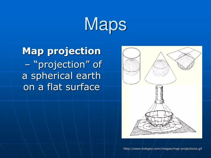
Maps. Map projection – “projection” of a spherical earth on a flat surface. http://www.kidsgeo.com/images/map-projections.gif. Latitude and Longitude. Latitude and Longitude are spherical coordinates on the surface of the earth PreTest… http://www.quia.com/quiz/294825.html. Latitude.

E N D
Maps Mapprojection – “projection” of a spherical earth on a flat surface http://www.kidsgeo.com/images/map-projections.gif
Latitude and Longitude Latitude and Longitude are spherical coordinates on the surface of the earth PreTest… http://www.quia.com/quiz/294825.html
Latitude • Angular distance measured in degrees North or South of the equator • Lines of latitude that run parallel to the equator. • Equator divides the globe into the Northern and Southern Hemispheres
Longitude • Angular distance measured in degrees East or West of the prime meridian. • lines of longitude, called meridians, run perpendicular to lines of latitude • all pass through both poles. • each longitude line is part of a great circle.
Equator—The line which encircles the Earth at an equal distance from the North and South Poles. • Meridian—any line of longitude; A great circle on the surface of the Earth, passing through the geographical poles and some third point on the Earth's surface. • Parallel—A circle or approximation of a circle on the surface of the Earth, parallel to the Equator and connecting points of equal latitude. • Prime Meridian—The meridian of longitude 0 degrees, used as the origin for the measurement of longitude. The meridian of Greenwich, England, is the internationally accepted prime meridian in most cases.
MercatorProjection • has correct shapes of continents, but their areas are distorted. Lines of longitude are projected onto the map parallel to each other (square world map)
Robinson Projection • has accurate continent shapes and shows accurate land area http://www.colorado.edu/geography/gcraft/notes/mapproj/mapproj.html
Gnomonic Projection • used to plot the shortest distance between two points, projected as if a sheet of paper were laid on a point of the Earth’s surface http://www.colorado.edu/geography/gcraft/notes/mapproj/mapproj.html
Conic (or polyconic) Projection • used to produce a map of small areas. They’re made by projecting points and lines from a globe onto a cone. http://www.colorado.edu/geography/gcraft/notes/mapproj/mapproj.html
Conic (polyconic) Projection • http://www-atlas.usgs.gov/articles/mapping/a_projections.html http://www.bartleby.com/images/A4images/A4conprj.jpg
Cool website • Follow the link below… http://www.nationalgeographic.com/xpeditions/hall/index.html?node=20
Map Scale – the relationship between the distances on the map and actual distances on Earth’s surface
3 types of map scales • Verbal: statement “1 inch equals 100 miles” • Graphic: line divided into equal parts and marked in units (bar scale) • Numerical: written as a fraction scale (1/100,000 and 1/24,000) or a ratio scale (1:100,000 or 1:24,000)
Which map scale do you see? http://www.calvin.edu/academic/geology/courses/topomap/scale/scaler.jpg
Topographic Maps shows the changes in elevation of Earth’s surface
Topographic Maps • Contour Line – a line on a map that connects points of equal elevation • Contour Interval – difference in elevation between two adjacent (side-by-side) contour lines http://raider.muc.edu/~mcnaugma/Topographic%20Maps/contour.htm
Rules to Remember • Contour lines: • close around hills and basins or depressions • never cross • only touch if there is a vertical slope/gradient (like a cliff) • that form V’s that pointupstream (to the source) whenever they cross streams
Landforms the smaller features of the earth’s landscape defined by their shape, size and elevation…
Mountain • – an elevated area of land, higher than a hill, with sloping sides
Valley • an area of land lower in elevation than its surroundings
Valley (topographic map) • The blue line is the river valley • Note the steep sides of the river walls
Plain • an extensive, flat area of land, usually without trees http://chapters.marssociety.org/canada/expedition-mars.org/ExpeditionTwo/files/photos/Stony-desert-plain.jpg
Plateau • A fairly flat area of land above surrounding land (area of flat land with high ‘relief’) http://parkerlab.bio.uci.edu/pictures/photography%20pictures/Sunset%20from%20Tonto%20Plateau.jpg
(Relief – the distance from the base to the top (peak, summit) of a landform) • Relief map… http://faculty.gg.uwyo.edu/heller/Sed%20Strat%20Class/SedStrat%208/canyon800x600.jpg
Canyon • a valley with very steep sides Canyon DiPetra, Grand Canyon, AZ http://photos.mongabay.com/it/749Petra.htm
Strait • a narrow passage of ocean water joining two larger bodies of water • ie. Strait of Gibraltar between Africa and Europe http://pds.jpl.nasa.gov/planets/images/full/earth/strait.jpg
Bay • a body of ocean water mostly surrounded by land and smaller than a sea or ocean http://content.answers.com/main/content/wp/en/d/d2/Wpdms_usgs_photo_san_francisco_bay.jpg
Peninsula • a land projection of land surrounded on 3 sides by water http://www.mlahanas.de/Greece/Regions/ManiPeninsula.html Mani Peninsula Satellite image
Island • land completely surrounded by water New Zealand's most active volcano, White Island, was in a state of frequent eruption from 1976 to 2000. http://www.geonet.org.nz/images/volcano/our-volcanoes/White-Island-28766-20-lge.jpg
Lagoon • a shallow body of salt water mostly or completely surrounded by land http://www.recreationvictoria.com/esquimaltlagoon/images/photos/esquimalt_lagoon-2.jpg
Archipelago • a group or chain of islands http://lincoln.midcoast.com/~prospec/wizolution/cad/archipelago.jpg
Archipelago a group or chain of islands
Congratulations – you found the hidden extra credit!!! Find: • The magnetic declination for our school • A bench mark (picture) • Locate the nearest bench mark to school • The latitude and longitude of our school down to the nearest tenth of a second. • The latitude and longitude of your house down to the nearest tenth of a second. Present this information to me after school any day before we finish the map unit…. Then sing the hokey-pokey-with me (only one verse) and get a bonus homework assignment.
Azimuthal • for example… polar projection… the north pole is ‘touching’ the map and the longitudinal lines radiate outward.