Download
1 / 17
170 likes | 177 Views
This presentation discusses the progress and updates in the implementation of the Terminal Doppler Weather Radar (TDWR) for National Weather Service (NWS) operations. It covers the use of TDWR data from other federal agencies, modifications made to the base radar to accept non-WSR-88D data, and the development of new output products compatible with AWIPS. The presentation also highlights the new storm analysis and precipitation products introduced in TDWR Phase 3.

E N D
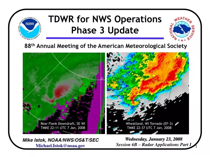
TDWR for NWS Operations Phase 3 Update 88th Annual Meeting of the American Meteorological Society Rear Flank Downdraft, SE WI TMKE 22:11 UTC 7 Jan, 2008 Wheatland, WI Tornado (EF-3) TMKE 22:37 UTC 7 Jan, 2008 Wednesday, January 23, 2008 Session 6B – Radar Applications Part I Mike Istok, NOAA/NWS/OS&T/SECMichael.Istok@noaa.gov
TDWR for NWS OperationsPhase 3 Update Coauthors: • Andrew D. Stern & Robert E. Saffle, Noblis, Inc. • Bill Bumgarner, BAE Systems • Brian R. Klein, Ning Shen, Yukuan Song & Zihou Wang, RS Information Systems • Warren M. Blanchard, Short and Associates Acknowledgments: • Mark Fresch of NWS Office of Hydrologic Development and Daniel Stein III of RS Information Systems
Overview of the TDWR SPG Program • Use weather radar data from other federal agencies • Establish a MOU with the FAA to gain nationwide access to TDWR data • Modify the base RPG to accept non-WSR-88D data • Develop output products that are compatible with AWIPS • Migrate existing algorithms for use with TDWR VCPs • Deploy SPG processing systems and establish dedicated TDWR communications to WFOs
New SPG Phase 3 Products Storm Analysis Products • Storm Tracking Information (STI) • Hail Index (HI) • Mesocyclone Detection (MD) • Digital Mesocyclone Detection (DMD) • Tornadic Vortex Signature (TVS) Derived Reflectivity Products • Vertically Integrated Liquid (VIL) • Echo Tops (ET) • Composite Reflectivity (CR/CZ)
New SPG Phase 3 Products Precipitation Products • One-Hour Precipitation (OHP) • Three-Hour Precipitation (THP) • User-Selectable Precipitation (USP) • Storm Total Precipitation (STP) • Hourly Digital Precipitation Array (DPA) • Digital Storm Total Precipitation (DSP) • Supplemental Precipitation Data (SPD) • Digital Hybrid Scan Reflectivity (DHR) • Hybrid Scan Reflectivity (HSR)
TDWR Example: Central Florida Tornadoes • 2 Feb 2007, 3-430AM EST • 3 tornadoes in a 70 mi discontinuous path • 21 fatalities, 118 injured • Peak Intensity, EF-3 • $270M property damage
TMCO 0.6 Deg Digital Reflectivity (DR) TDWR: TMCO Loop: 02/02/07 08:29Z – 08:59Z Maximum Range 225mi/416km Overlays: None
TMCO 0.3 Deg Digital Reflectivity (DR) TDWR: TMCO Loop: 02/02/07 08:30Z – 09:05Z Maximum Range 48mi/90km Overlays: None
TMCO 0.3 Deg Digital Velocity (DV) TDWR: TMCO Loop: 02/02/07 08:30Z – 09:05Z Maximum Range 48mi/90km Overlays: None
TMCO Composite Reflectivity (CR) TDWR: TMCO Loop: 02/02/07 08:29Z – 09:02Z Maximum Range 48mi/90km Overlays: Storm Track Mesocyclone
TMCO Vertically Integrated Liquid (VIL) TDWR: TMCO Loop: 02/02/07 08:29Z – 08:59Z Maximum Range 48mi/90km Overlays: Storm Track
TMCO Storm Total (STP) & One Hour Precipitation (OHP) TDWR: TMCO Loop: 02/02/07 08:29Z – 08:59Z Maximum Range 48mi/90km Overlays: None
Upcoming Changes to the TDWR • Rehost TDWR RDAs • Improve supportability & add new signal processor • New PRI Methodology • New multi-PRI mode vs. dual-PRI phase-coded mode • Probable scanning strategy revision • Drop duplicate velocity dealiasing scan • In Hazardous Mode, add second pass at 1 deg elevation • Fine tune antenna rates and elevation angles • New Dealiased Velocity Fields • No longer provide unconditioned velocity data • Data Compression Algorithms • For use in establishing reliable communications at lower cost
Future Plans • Complete deployment of SPGs to WFOs by end of FY 2008 • Level 3 product availability via AWIPS central collection • Planning for Level 2 availability • SPG adaptation for other FAA radars (ARSR-4, ASR-9/11) • SPG adaptation for non-FAA radars
For Additional Information • Michael Istok • National Weather Service Headquarters Systems Engineering Center, Silver Spring • 301-713-0763 x 103 • Michael.Istok@noaa.gov