Download
1 / 57
580 likes | 815 Views
Weather and Climate. Chemistry 2014. Weather & Climate Definitions. Weather- “the state of the atmosphere with respect to heat or cold, wetness or dryness, calm or storm, clearness or cloudiness”.

E N D
Weatherand Climate Chemistry 2014
Weather & Climate Definitions • Weather- “the state of the atmosphere with respect to heat or cold, wetness or dryness, calm or storm, clearness or cloudiness”. • Climate – “the average course or condition of the weather at a place usually over a period of years (at least 30 yrs) as exhibited by temperature, wind velocity, and precipitation”
Types of Weather Observations: • Temperature • Dewpoint • Barometric Pressure • Wind Speed and Direction • Cloud Cover & Type • Present Weather • Ships • Buoys • Commercial Aircraft (ACARS) • Satellite All of this data goes into forecast models
Measuring Weather Conditions • A rain gauge measures how much rain or snow has fallen. • A thermometer measures temperature, or how hot or cold the air is. • Barometers • are used to • measure air • pressure • An anemometer measures how fast the wind is blowing. • A wind vane shows which direction the wind is blowing. It points to the direction the wind is coming from. Beaufort Wind Speed Scale is has a range from 0 for calm to 12 for a hurricane with waves greater than 37 feet
Clouds • Amount and height • Cloud type is done by sight only More on this later
WHY DO WE HAVE WEATHER ? • Why is there wind? Why does it blow from one direction one day and another the next? • Why is it rainy one day and dry the next? • How come it’s cold in the winter? • How can we have hail in the summer? • What causes snow and freezing rain?
Earth’s Atmosphere Earth’s Atmosphere
exosphere—contains few particles that move into and from space. thermosphere—temperature increases with height. low air pressure The International Space Station orbits Earth in this layer. mesopause—boundary betweenmesosphere and thermosphere; coldest place on Earth. mesosphere—the layer in which most meteors burn up stratosphere—contains the ozone layer; the layer where volcanic gases can affect the climate • troposphere—layer closest to Earth’s surface • -Most atmospheric mass • -Where weather occurs • -Where air pollution collects • -Temperature decreases with height Notice layers of atm where temp increases with altitude and where temp decreases with altitude
Why do we care about weather and climate? • Daily concerns – what to wear, flight delays, etc • Travel • Agriculture and Food concerns • Safety • Insurance and property damage • Future
If we were to pick one term to help explain why we have weather? You might pick heat or sun….but another good choice would be Convection
Convection is the transfer of heat,usually in gases or liquids.
After the atmosphere is warmed by radiation and conduction, the heat is transferred throughout the atmosphere by convection. • Since warmed air has more space between the molecules (expands), it’s less dense and rises • Cooled air is more dense (condenses) and tends to sink • In general, air near the equator tends to rise and air near the poles tends to sink Jet streams are usually found somewhere between 10-15 km (6-9 mi) above the earth's surface
Air Temperature • As solar energy reaches the Earth, equatorial regions heat up more than the poles. • Warm air and water at the equator travel pole-ward while cold air and water at the poles travel equator-ward in an attempt to equalize this temperature contrast. • It is the atmosphere's continual struggle for temperature balance that brings us our changing weather.
The Weather Highways • Additionally, the rotation of the earth creates the Coriolis effect. • The Coriolis effect causes the air and water to be deflected to the right, north of the equator. • This creates global weather highways
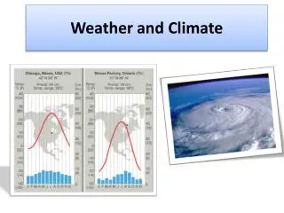
The Westerlies • Because of our latitude, most of our weather comes from the west • Looking at the top weather map, what type of weather might we expect? • What type of weather might we expect in a few days? What is the prediction for this weather map?
Let’s break for a short review 1. Weather occurs in the _____ layer of the atmosphere. 2. Transfer of heat in liquids or gases is_____ 3. _____ air is dense and tends to sink. 4. Cold air holds _____ moisture than warm air 5. The Coriolis effect causes the air and water to be deflected to the _____ of the equator
How did you do? 1. TROPOSPHERE 2.CONVECTION 3. COLD 4. LESS 5. RIGHT
Now What? • Ok, so we know that the weather moves around on these highways and that warm air rises and cold air sinks. • But why is it sunny one day, and rainy the next?
Air Pressure • air pressure is caused by the weight of the air pressing down on the Earth, the ocean and on the air below • the pressure depends on the amount of air above the measuring point and falls as you go higher • air pressure changes with weather L The lowest atmospheric pressure is found at the center of a low pressure system, labeled with a capital L on a weather map.
… and Weather • air in a high pressure area compresses and warms as it descends (drops) • the warming inhibits the formation of clouds, meaning the sky is normally sunny in high-pressure areas • haze and fog might form • the opposite occurs in an area of low pressure
Let’s take another look at the weather map • Notice that there are H’s and L’s on the map • There are also blue lines with spikes and red lines with half circles • Let’s take a closer look!
High Pressure Areas • When cooler air sinks and is warmed, the air can hold more moisture • This usually means sunny skies • Winds tend to move clockwise around a high H over your home area means likely fair weather
Low Pressure Areas • When warm air rises and is cooled, the air can not hold as much moisture • Often, these areas are associated with precipitation and stormy weather • Winds tend to move counter clockwise around the low L over your home area means probably stormy weather
Fronts and Air Masses • An air mass is a large body of air whose temperature and moisture are fairly similar at a given altitude • Fronts are boundaries separating different air masses
The Air Masses • (continental polar) : cold, dry stable • (continental tropical) : hot, dry, stable air aloft, unstable at the surface • (maritime polar) : cool, moist, unstable • (maritime tropical) : warm, moist, unstable
Ok, now we see the difference in the air masses • Let’s look at the different fronts and their impact on weather • Can you see the four different types of fronts on the map?
Warm Fronts • A warm front is warm air displacing cool air diagram • Shallow leading edge warm air must “overrun” cold air • These are usually slow moving
Cold Fronts • Cold air advances into region of warm air • Intensity of precipitation greater, but short lived • Clearing conditions after front passes • Usually approaches from W or NW
Stationary Fronts • Surface positions of the front do not move • Often a region of clouds
Occluded Fronts • Cold front overtakes warm front • Often found close to the low pressure center
Ready for a little quiz?You’ll need a sheet of paper • Write your answers as we go • Here we go!
1. Winds in a low pressure system move _____ around the low. 2. What type of front can be found close to point D? 3. Which of these fronts would you expect to have greater precipitation, but be short lived as the front passes?
4. Give the name of the air mass that would have the following characteristics: cool, moist, unstable 5. That important weather word that refers to the transfer of heat. 6. This causes air and water to be deflected to the right, north of the equator. 7. Which of the weather highways usuallycontrols our weather?
8. Warm air holds ( more or less ) moisture than cold air? 9. If there is a big H on the weather map where you live, would you expect fair or stormy weather? 10. Generally, what happens to air near the equator and air near the poles? Bonus: What is wind?
Answers 1. Counterclockwise 2. Cold 3. Cold 4. Maritime polar 5. Convection 6. Coriolis Effect 7. Westerlies 8. More 9. Fair 10. In general, air near the equator tends to rise and air near the poles tends to sink Bonus: horizontal movement of air from are of high pressure to an area of lower pressure
Cloud Types Picture taken from: http://commons.wikimedia.org/wiki/File:Cloud_types.jpg **** Cloud making demo?
Cloud Formation • Rising Air • Lifted Condensation Level / Dew Point • Condensation Nuclei • -Small droplets in the atmosphere around which cloud droplets can form • Clouds form from millions of droplets
Cloud Types • Low Clouds (Cumulus, Stratus) • 0 to 2000 meters • Middle Clouds (Altostratus, Altocumulus) • 2000 to 6000 meters • High Clouds (Cirrus, Cirrocumulus, Cirrostratus) • 6000 meters and above • Rain Clouds (Cumulonimbus, Nimbostratus)
Precipitation • Coalescence • Cloud droplets collide to form larger droplets • Precipitation • Rain, Snow, Sleet, Hail
Thunderstorms • Can produce some of the most violent weather conditions on Earth • May have hail, strong winds, lightening, thunder, rain and tornadoes • Supercells – self-sustaining, extremely powerful storms with intense, rotating updrafts • Can last for several hours with updrafts up to 240km/hr • 10% of storms are considered severe
moist air rises due to frontal zone lifting causing loss of heat leading to cumulus clouds with updrafts • severe thunderstorms occur when cold front approaches warm front (which supplies moisture and energy) • winds over 60 mph • hail > 3/4 inch
Lightning • Electricity caused by a rapid rush of air in a cumulonimbus cloud • Friction between updrafts and downdrafts separate electrons • Positive atoms at the top of the cloud • Negative atoms at the bottom of the cloud • Transfer of energy in form of heat, sound, and light • Lightening strikes has about million volts • 5x hotter than heat from sun