Download
1 / 7
70 likes | 173 Views
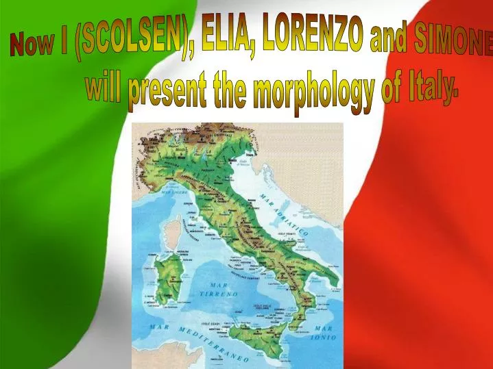
Now I (SCOLSEN), ELIA, LORENZO and SIMONE will present the morphology of Italy. CLIMATE OF ITALY.

E N D
Now I (SCOLSEN), ELIA, LORENZO and SIMONE will present the morphology of Italy.
CLIMATE OF ITALY Italy has a variety of climate systems. The inland northern areas of Italy (for example Turin, Milan, and Bologna) have a humid subtropical climate, while the coastal areas of Liguria and the peninsula south of Florence generally fit the Mediterranean climate profile.
CLIMATE OF ITALY Between the north and south there can be a considerable difference in temperature, above all during the winter: in some winter days it can be −2 °C and snowing in Milan, while it is 8 °C in Rome and 20 °C in Palermo. Temperature differences are less extreme in the summer. The east coast of the peninsula is not as wet as the west coast, but is usually colder in the winter. The east coast north of Pescara is occasionally affected by the cold bora winds in winter and spring. On the coast from Ravenna to Venice and Trieste, snow falls more rarely: during cold spells from east, the cold can be harsh but with bright skies; while, during the snowfalls that affects northern Italy, the Adriatic coast can see a milder Scirocco wind which makes snow turn to rain—the mild effects of this wind often disappear just a few kilometres inside the plain, and sometimes the coast from Venice to Grado sees snow while it is raining in Trieste, the Po River mouths and Ravenna. Rarely, the city of Trieste may see snow blizzards with north-eastern winds; in colder winters, the Venice Lagoon may freeze, and in the coldest ones even enough to walk on the ice sheet.Tuscan landscape.
Summer is usually more stable, although the northern regions often have thunderstorms in the afternoon/night hours and some grey and rainy days. So, while south of Florence the summer is typically dry and sunny, in the north it tends to be more humid and cloudy. Spring and Autumn weather can be very changeable, with sunny and warm weeks (sometimes with Summer-like temperatures) suddenly broken off by cold spells or followed by rainy and cloudy weeks. In the north precipitation is more evenly distributed during the year, although the summer is usually slightly wetter. Between November and March the Po valley is often covered by fog, especially in the central zone (Pavia, Piacenza, Cremona and Mantua), while the number of days with lows below 0 °C (32 °F) is usually from 60 to 90 a year, with peaks of 100–110 days in the mainly rural zones.[2] Snow is quite common between early December and early March in cities like Turin, Milan and Bologna, but sometime it appears in late November or late March and even April.
Summer temperatures are often similar north to south. July temperatures are 22–24 °C (71.6–75.2 °F) north of the river Po, like in Milan or Venice, and south of the river Po can reach 24–25 °C (75.2–77 °F) like in Bologna, with fewer thunderstorms; on the coasts of Central and Southern Italy, and in the near plains, average temperatures goes from 23 °C to 27 °C (80.6 °F). Generally, the hottest month is August in the south and July in the north; during these months the thermometer can reach 38–42 °C (100.4–107.6 °F) in the south and 32–35 °C (89.6–95 °F) in the north; Sometimes the country can be split as during winter, with rain and 20–22 °C (68–71.6 °F) during the day in the north, and 30–40 °C (86–104 °F) in the south; but, having a hot and dry summer does not mean that Southern Italy will not see rain from June to August. The coldest month is January: the Po valley's mean temperature is between -1–1 °C (30.2–33.8 °F), Venice 2–3 °C (35.6–37.4 °F), Trieste 4 °C (39.2 °F), Florence 5–6 °C (41–42.8 °F), Rome 7–8 °C (44.6–46.4 °F), Naples9 °C (48.2 °F), and Cagliari 12 °C (53.6 °F). Winter morning lows can occasionally reach -30 to -20 °C (-22 to -4 °F) in the Alps, -14 to -8 °C (6.8 to 17.6 °F) in the Po valley, −7 °C (19.4 °F) in Florence, −4 °C (24.8 °F) in Rome, −2 °C (28.4 °F) in Naples and 2 °C (35.6 °F) in Palermo.
The north of Italy is bordered by the Alps and bordered by France, Switzerland, Austria and Slovenia. The center Italy extends south in the Mediterranean, forming a peninsula surrounded by the Tyrrhenian, Adriatic and Ionian Seas. Insular Italy includes Sicily and Sardinia. The microstates of San Marino and Vatican City are enclaves, the municipality of Campione d'Italia is an exclave located in Switzerland. Geographically, the Italian region (divided into mainland Italy, mainland and island), is joined to the European continent by the chain of the Alps. Thanks to its location, it is ideally a gateway to Asia and Africa. Italy also separates the western basin of the Mediterranean Sea from the central one, i.e. the Tyrrhenian Sea from the Ionian Sea. To the north of Salento goes the long, narrow inlet of the Adriatic Sea. The islands of Sardinia and Corsica, then divided by the Tyrrhenian Sea Sardinia. The moountain rivers of glacial origin are subject to floods in spring and summer, because of the melting of the snow that falls in the warmer.
Italy, because of the presence of different mountains, springs and glaciers, is rich in water courses. In general, the rivers that originate in the Apennines are not very long and have torrential character, as opposed to those of the Alps. The largest river, both for the length and importance, is the Po (652 km long) [45] crossing the Po valley, flows into the Adriatic Sea. The largest Italian lake is Lake Garda and the deepest is Lake Como (410 m) [46]. The Italian coast spreads over 7,456 km and has different forms (cliffs, sandy, stony, ecc). Italian soil, man-strong, has several features (volcanic endolagunare, limestone, etc.).. In Italy the hilly areas outweigh mountainous areas and those flat, the average altitude of its territory is about 337 meters above the sea. The mountain ranges stretch for most of the nation. It belongs to Italy around the southern side of the Alpine, with a length about 1,000 km. The highest peaks are located in the Western Alps, where there are several peaks over 4,000 m including the Matterhorn (4,478 m), Monte Rosa (4,634 m) and Mont Blanc (4,810 m), the highest mountain in Europe. The Apennine mountain chain runs along the peninsula, from Liguria to Sicily, ending in the Madonie; the Gran Sasso mountain (2,912 m), located in Abruzzo, is its highest peak. Italy is also known for the presence of numerous volcanoes, the most famous are the Vesuvius, Etna, (3,343 m), the highest volcano in Europe, and Stromboli. Only one quarter of the size of the Italian region is occupied by plains. The Po Valley is the largest of all. It is an expanse of alluvial formed by the river Po and its tributaries. [41] Below, for size, Tavoliere, a plain of lifting [42] and Campidano, another floodplain. [43] The lowest point of Italy is located in the village of Contane in Ferrara (-3.44 m). The islands are Sicily and Sardinia; there are numerous smaller islands, most of which is gathering a group of islands, [44] including: the Tuscan Archipelago, the volcanic islands, the Aeolian Islands, the Egadi and trembling, Pelagie Archipelago and the Archipelago of La Maddalena.