Download
1 / 89
900 likes | 1.09k Views
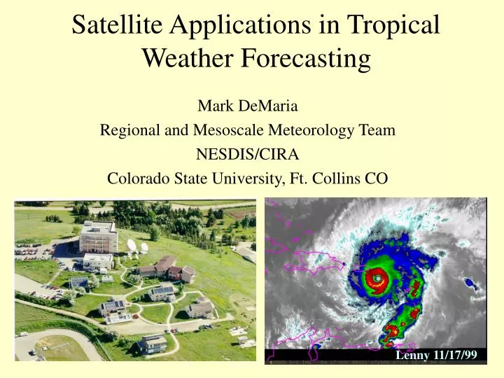
Satellite Applications in Tropical Weather Forecasting. Mark DeMaria Regional and Mesoscale Meteorology Team NESDIS/CIRA Colorado State University, Ft. Collins CO. Lenny 11/17/99. Acknowledgments. RAMMT

E N D
Satellite Applications in Tropical Weather Forecasting Mark DeMaria Regional and Mesoscale Meteorology Team NESDIS/CIRA Colorado State University, Ft. Collins CO Lenny 11/17/99
Acknowledgments • RAMMT • Roger Phillips, Ray Zehr, Jack Dostalek, John Knaff, Bernadette Connell, Stan Kidder • TPC • Jiann-Gwo Jiing (SOO), Richard Pasch, Michelle Huber, Bill Frederick • CIMSS • Chris Velden, Gary Wade • NESDIS ORA • Roger Weldon
Outline • General Circulation in the Tropics • ITCZ • Subtropical Ridge • Tropical Upper Tropospheric Trough • Synoptic-Scale Weather Systems • Upper-level lows • Tropical Waves • Tropical Cyclones • Dvorak method • Environmental interactions • Measurements from Polar orbiting satellites
Terminology • Channel 1 - Visible - .6 m ( .52- .72) • Channel 2 - Shortwave IR - 3.9 m (3.78- 4.03) • Channel 3 - Water Vapor - 6.7 m (6.47-7.02) • Channel 4 - Longwave IR - 10.7 m (10.2-11.2) • Channel 5 - Split Window - 12.0 m (11.5-12.5) • Microwave frequencies 20-90 Ghz (1.5-0.3 cm) 1 2 3 4 5 1 2 3 4 5
Hadley Cell DJF JJA P (mb) -90 -60 -30 0 30 60 90 -90 -60 -30 0 30 60 90 Walker Cells
Global WV Imagery Composite 22 August 1998 (Real-time data available from CIMSS web site) 0000 UTC 2100 UTC
Tropical Upper-Level Lows • Typically form within TUTT • Cold-core systems • Shallower circulation than mid-latitude lows (little circulation below 500 mb) • Often produce precipitation • Can influence intensity and track of tropical cyclones • Can be tracked using water vapor imagery
Cold-low in NCEP Analysis 8/19/96 0000 UTC 300 mb 700 mb
Perturbation Temperature Cross-Section from NCEP Analysis 8/26/96 0000 UTC
Schematic Representation of Cold Low Structure (from Whitfield and Lyons, WF, 1992)
Radiation Analysis of WV Imager Channel for Idealized Sounding
16-Frame Water Vapor Imagery Loop7/26/98 02:45 to 7/29/98 20:45 Formation of a Cold-Low
TPC Tropical Analysis and Forecast BranchCold-Low Study • Period of Study: Aug. 12-Oct. 1, 1996 • Domain: 0-35 N, 110-20 N • Cold-low centers tracked using GOES WV imagery • 47 lows during 50 days • Average Duration of 3 days, Max of 12 days • Up to 8 lows in domain at once (average of 3) • Vorticity center present in NCEP 200 mb analyses for nearly all cold lows identified by satellite observations • Average NECP analysis location error of 100 nm
NCEP Aviation Model Cold-Low Average Track Error 600 Extrapolation Persistence 400 Cold Lows 200 1996 Tropical Cyclones
Tropical Waves • Formation near western Africa • Barotropic/baroclinic instability, PV gradient changes sign • Secondary instability region in Western Caribbean • Maximum amplitude near 700 mb • Period of 2-5 days, wavelength 2-3000 km, May-Dec • Precipitation associated with waves • About 2/3 of Atlantic TC genesis associated with waves • Role in east Pacific tropical cyclogensis
Seasonal Mean PV at 750 mb (Molinari et al, 1997) Mean meridional wind from GATE wave composite (Reed et al, 1977)
TAFB Methods for Tracking Waves • TAFB tropical surface analysis generated 4 times per day, includes surface wave positions • Rawindsone time series • Surface data when available • Satellite analysis over west Africa • Animation of channels 1, 2 and 4 indicates rotation • Hovmoller satellite diagrams for continuity across tropical Atlantic • NCEP aviation model analyses and forecasts
Dakar Sounding (15 N, 18 W) Time Series August 1995-97 95 96 97
08/01/96 08/16/96 Tropical Strip Time Series 40 E-40 W 0 N-15 N 08/31/96 08/15/96 20 W 40 E 20 W 40 E
Tropical Cyclogenesis • Eastern Pacific • Interaction of tropical waves/monsoon trough • Includes region of maximum global storm formation • Atlantic • 2/3 of storms from tropical waves • Some baroclinic, subtropical and monsoon trough developments • Very “peaked” season • Experimental genesis parameter under development
Climtological Tropical Cyclone Frequency (From WMO Global Guide To TC Forecasting)
Tropical Atlantic Genesis Parameter • Developed from cases since 1991 • Genesis variables • zonal shear (NCEP analyses) • vertical stability (NCEP analyses) • Mid-level moisture (Cloud-cleared GOES-8 water vapor brightness temperature, 1996-99) • 5-day running means 8-18 N, 30-50 W • Variables scaled from -1 to 1 • Genesis parameter = shear x stability x moisture
Tropical Atlantic Genesis Locations 1991-99 45 Total Cases: 7 Un-named TDs 13 TS 9 Non-major Hurricanes 16 Major Hurricanes
Climatological Shear, Stability, WVBT (Scaled) Favorable Marginal Unfavorable
Genesis Parameter in 1999 Shear Stability WVBT GP (www.cira.colostate.edu/ramm/gparm/genesis.asp)
5-Day Running Mean Cloud Cleared Water Vapor Imagery for August 1999 LOOP
Tropical Cyclone Classification • NHC has responsibility for Atlantic and east Pacific basins • Atlantic: 10 storms, 6 hurricanes • East Pacific: 16 storms, 10 hurricanes • Aircraft recon available only for Atlantic west of 55 W • Majority of center and intensity estimates from GOES satellite data • TAFB, SAB, AFWA provide classifications
Overview of the Dvorak Technique • Visible and Infrared Technique • Simplified Visible Technique given here (See Technical Report for full details) • Uses patterns and measurements as seen on satellite imagery to assign a number (T number) representative of the cyclone’s strength. • The T number scale runs from 0 to 8 in increments of 0.5.
Overview of the Dvorak Technique Cont’d • In the following examples, only the Data T Number (DT) will be calculated, the final (official) T number assigned to a tropical cyclone includes further considerations. • DT computations familiarize one to various tropical cyclone patterns.
Four Basic Patterns • Curved Band Pattern • Shear Pattern • Central Dense Overcast (CDO) Pattern • Eye Pattern • Pattern is not always obvious • Pattern typically varies with time
Finding the Cloud System Center (CSC) • First step in the Dvorak technique • From Dvorak (1985): “The cloud system center is defined as the focal point of all the curved lines or bands of the cloud system. It can also be thought of as the point toward which the curved lines merge or spiral.” • Center not always obvious, especially at night • TPC technique combines channel 2 and 4
Curved Band Pattern Cont’d 1.0 2.0 2.5 3.0 3.5 4.0 4.5 DT Number
Shear Pattern DT Numbers 1° latitude = 60 nautical miles (nmi) = 111 km
Central Dense Overcast (CDO)Hurricane Georges 9/21/98 1545 UTC
CDO • No eye • DT number determined by CF+BF=DT • CF=CENTRAL FEATURE • BF=BANDING FEATURE • DT=DATA T NUMBER
CDO Central Feature (CF) • Measure Diameter of CDO in degrees latitude • For a well defined CDO • 3/4 ° CF=2 • 1 1/4 ° CF=3 • 1 3/4 ° CF=4 • >2 1/4 ° CF=5 • For an irregular CDO • 1° to 1 1/2 ° CF=2 • >1 1/2 ° CF=3