Download
1 / 33
330 likes | 336 Views
Longitudinal Bedform Classification for Comparison of Restored and Unrestored Reaches of the Provo River, Utah. Physical Controls on Hyporheic Flow By Randy Goetz. Presentation Outline. Motivation Project Goals Procedure Results Conclusions. Project Motivation and Background.

E N D
Longitudinal Bedform Classification for Comparison of Restored and Unrestored Reaches of the Provo River, Utah Physical Controls on Hyporheic Flow By Randy Goetz
Presentation Outline • Motivation • Project Goals • Procedure • Results • Conclusions
The Provo River Restoration Project • Restore 13 km of channelized river to a complex, dynamic, self-sustaining system. • Complete channel reconfiguration, increase habitat complexity, frequent floodplain inundation, and rejuvenate riparian habitat.
Hyporheic Flow • Integral component of nutrient transport and cycling processes in rivers • Hydrological and biological intermediary between stream and riparian habitats • Potentially critical to the successful restoration of stream ecosystems
Longitudinal Physical Controls Downwelling Upwelling
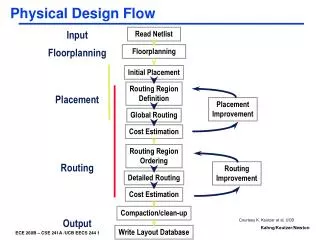
Project Goals • To apply a simple algorithm to automate classification of bedforms (riffles, pools, rapids) from total station survey data. • Quickly classify and visualize geomorphic unit maps. • Compare bedform spatial and physical characteristics amongst restored and unrestored reaches of the Provo River.
PROCEDURE • Bring arbitrary total station survey coordinates into UTM for display with digital aerial photos.
PROCEDURE • Bring arbitrary total station survey coordinates into UTM for display with digital aerial photos. • Adjust survey points
PROCEDURE • Bring arbitrary total station survey coordinates into UTM for display with digital aerial photos. • Adjust survey points • Create a line feature class with slope information.
PROCEDURE • Bring arbitrary total station survey coordinates into UTM for display with digital aerial photos. • Adjust survey points • Create a line feature class with slope information. • Apply algorithm to classify each segment based on water surface slope.
PROCEDURE • Bring arbitrary total station survey coordinates into UTM for display with digital aerial photos. • Adjust survey points • Create a line feature class with slope information. • Apply algorithm to classify each segment based on water surface slope. • Create a new polygon feature class with segments surrounding each unit type.
PROCEDURE • Bring arbitrary total station survey coordinates into UTM for display with digital aerial photos. • Adjust survey points • Create a line feature class with slope information. • Apply algorithm to classify each segment based on water surface slope. • Create a new polygon feature class with segments surrounding each unit type. • Create a new line feature class whose segments comprise the center line of each unit. Join the attribute table of this feature class to the polygon feature class for a final table with unit type, and length information.
RESULTS • Unit Maps for 4 reaches.
Restored 1 Complete 2000 Length: 828 m Average Slope: 0.011 Average Pool Length: 55 m Average Riffle Length: 45 m Average Rapid Length: 28 m Unrestored 1 Current Construction Length: 526 m Average Slope: 0.0076 Average Pool Length: 29 m Average Riffle Length: 44 m Average Rapid Length: 11 m Unrestored 2 Current Construction Length: 652 m Average Slope: 0.013 Average Pool Length: 72 m Average Riffle Length: 57 m Average Rapid Length: 32 m Restored 2 Complete 2003 Length: 590 m Average Slope: 0.0055 Average Pool Length: 80 m Average Riffle Length: 38 m Average Rapid Length: N/A
RESULTS • Unit Maps for 4 reaches • Unit distribution
RESULTS • Unit Maps for 4 reaches • Unit distribution • Riffle analysis
CONCLUSIONS • The use of GIS in classifying bedforms proved relatively fast, and useful in visualizing unit location and distribution.
CONCLUSIONS • The use of GIS in classifying bedforms proved relatively fast, and useful in visualizing unit location and distribution. • Analysis of survey data was enhanced through GIS processing.
CONCLUSIONS • The use of GIS in classifying bedforms proved relatively fast, and useful in visualizing unit location and distribution. • Analysis of survey data was enhanced through GIS processing. • Results suggest that there are not consistently significant physical differences in longitudinal controls between restored and unrestored reaches.
CONCLUSIONS • The use of GIS in classifying bedforms proved relatively fast, and useful in visualizing unit location and distribution. • Analysis of survey data was enhanced through GIS processing. • Results suggest that there are not consistently significant physical differences in longitudinal controls between restored and unrestored reaches. • Enhancing the data content should lead to a useful predictive and comparative tool in forming and testing hypothesis concerning geomorphic controls on hyporheic exchange.