Download
1 / 17
170 likes | 354 Views
Marine Geoscience Seismic Data System Access for education and research. Field Data Center (LDEO) Marine Seismic Data Center (UTIG). Scope and Goals. preserve U.S. academic digital seismic reflection data and supporting information help investigators share project data and products

E N D
Marine Geoscience Seismic Data SystemAccess for education and research Field Data Center (LDEO) Marine Seismic Data Center (UTIG)
Scope and Goals • preserve U.S. academic digital seismic reflection data and supporting information • help investigators share project data and products • help define and unify seismic-related metadata
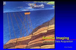
Seismic System Components • Field Seismic Data Center (LDEO) • serves digital field data • R/V Ewing 57 cruises 1990-2005 • R/V Langseth (operational September, 2007) • Marine Seismic Data Center (UTIG) • serves digital processed products • stacks, migrations, SCS, UTIG OBS, 3D, chirp, etc. • serves older (mostly UTIG) field data from 85 cruises • serves other types of seismic data not otherwise being preserved
Marine Seismic Data Center (MSDC) • Collect and serve • acquisition and processing info • SEG-Y binary data • create trace geographic positions, line-by-line • create annotated raster images Cruise-organized metadata
MSDC Metadata Follow FGDC and developing ontologies for marine and seismic data. Developing interop with MGDS (with REST) tests metadata structure and convergence.
MSDCAcquiring Metadata and Data • Reluctance of some investigators to contribute processed data • Addressed these concerns by: • pushing citation information with downloads • sharing usage information with data providers • allowing for access restriction • though metadata is all visible • ultimate arbitrator is project funding agency
MSDC Registration • Countries (62): • 40% U.S. • 6% United Kingdom • 4% Canada, India • 3% Germany, Australia, Brazil • Enterprise: • 71% Academic & Government • 20% Commercial • 7% Personal • 2% Undeclared
MSDC User Activity *=SEGY, navigation and large images +estimated
MSDC Tool Set • view and select SEG-Y, images, navigation • map-based search • metadata-based search • Google Earth formatted files • external access to metadata • xml metadata service in development • map services support(www.ig.utexas.edu:8080/geoserver/wms) • custom seismic images • automated download cart
Custom Images • create custom images with window selection, aspect ratio, filtering and amplitude control. • produces gif and pdf files.
Selection and Downloading • Selection is done from maps, lists and captions. • Automated system with intervention only when restricted data sets are requested. • Contributors are supplied monthly with information on downloads to help overcome reluctance to contribute and share data.
Data Discovery • creating comprehensive catalogs for users will: • simplify search • map-based discovery more valuable to users for some data, such as seismics • both catalogs and maps provide paths to more information and data • challenge--the comprehensive part • for example, U.S. seismic data • just in the U.S. there are (more than) 6 institutions with seismic data • because funding and individual and institutional priorities vary widely, some will never participate • efficient mapping method issues • WMS/WFS large files, slow (unless windowed or decimated) • Google Earth virtual globe (maybe, but commercial product limitations) • well-known educational and cross-generational browser • data provider controls information in the placemark, has complete ‘ownership’ control