Download
1 / 3
30 likes | 140 Views
Convective Storm Forecasting 1-6 Hours Prior to Initiation . John Mecikalski and John Walker, Univ. Alabama-Huntsville, Huntsville, AL Dan Lindsey and Louie Grasso NOAA/NESDIS/STAR/RAMMB and CIRA, Fort Collins, CO Chris Velden and Steve Wanzong, CIMSS, Madison, WI Bob Rabin, NSSL, Norman, OK

E N D
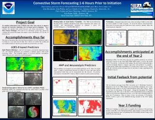
Convective Storm Forecasting 1-6 Hours Prior to Initiation John Mecikalski and John Walker, Univ. Alabama-Huntsville, Huntsville, AL Dan Lindsey and Louie Grasso NOAA/NESDIS/STAR/RAMMB and CIRA, Fort Collins, CO Chris Velden and Steve Wanzong, CIMSS, Madison, WI Bob Rabin, NSSL, Norman, OK Brian Vant-Hull, CREST, New York, NY Project Motivation and Goal One of the greatest difficulties in severe storm forecasting is deciding where and when storms will initially form. Current numerical models struggle with this problem and often have large errors in their 1-6-hour forecasts for convective initiation (CI). The overall goal of this proposal is to develop a single objective system that predicts where and when storms will form 1-6 hours prior to initiation. Institutional Plans CIRA: Utilize the split window difference (10.35–12.3 µm) to identify regions of enhanced or deepening low-level water vapor to help predict where and when convective clouds will form CIMSS: Produce Mesoscale Atmospheric Motion Vectors matching ABI temporal resolution and calculate fields of convergence, divergence, vorticity, and shear UAH: Heating Index and Land Surface Variability indices, and their associated gradients, will be examined for their utility to predict CI on “synoptically calm” days NSSL: Wind observations from the WSR-88D network using the Variational Doppler Radar Analysis System(VDRAS) will be used to provide a more complete picture of the pre-storm wind and moisture fields. CREST: To assist with algorithm validation, radar echoes and National Lightning Detection Network data will be used to catalogue when CI occurs, and the WDSII Segmotion algorithm, along with satellite and model winds, will be used to back-track clouds into the cloud free regions.
Atmospheric Winds, Convergence Low Level Water Vapor Evaluation Cloud level winds x x Cloud-50 mb winds x x x x x t-3 hr x Cloud-100 mb winds t-2 hr t-1 hr CI t = 0 t-4 hr t-5 hr Synthetic split window difference observations from 20 April 2011. Note that the east-west maximum in central Texas is a precursor to convective clouds and eventually convective initiation there. • Back trajectories in clouds will be followed from initiation of severe weather based on IR satellite using WDSSII segmotion algorithm. • When clouds disappear, clear-air trajectories will be followed back to initiation - 6 hours using NWP analysis winds at several different levels below the one that best matches the cloud trajectory. • Maps to be created of time to initiation for each location. t-6 hr • ABI top of atmosphere radiances have been generated for May 21, 1700 UTC to May 21, 2015 UTC. • The GOES-R AWG Winds Algorithm isn’t significantly impacted by using the “quick” forward model to generate visible reflectances. Project Components… Differential Surface Heating Land-Surface Variability (LSV) is a means of evaluating locations where elevation gradients, land cover type, and gradients in NDVI, can enhance the occurrence of convective cloud development. Antecedent rainfall is used to estimate how heating is partitioned between latent and sensible. Project Challenge The formation of an automated probabilistic system that predicts CI 1-6 hours in advance. To produce a continuous forecast in space and time, one approach is to use NWP CI forecasts as a first guess, then modify it from information gleaned from these satellite techniques. Sensible heating gradients are formed once incoming net radiation is known (from GOES), and hence locations where differential heating may lead to the formation of non-classical meso-scale circulations, and hence regions where CI is more favored in 1-6 htimeframes
Work completed to date… • 21 May 2011 was chosen for the initial case study, and the NSSL WRF was re-run so that 5-minute data could be saved • WRF output was used to generate simulated split window difference output, and the loop above shows that regions with locally increasing values (green to yellow to red) predicted where clouds (blue) would form. • Green areas indicate Doppler radar-derived convergence, overlaid on parallax-corrected GOES-13 Visible imagery from 21 May 2011 • The yellow circles highlight regions of dryline convergence detected by the clear-sky radar technique