Download
1 / 32
320 likes | 534 Views
Meteorological and Environmental Data in Data base PostgreSQL ( PostGIS / WKT Raster) and querying by web. Kleber R. da Paixão Ataíde. Meteorologist INMET, PHD student in Geoprocessing and environmental analysis.

E N D
Meteorological and Environmental Data in Data base PostgreSQL (PostGIS / WKT Raster) and querying by web. Kleber R. da Paixão Ataíde Meteorologist INMET, PHD student in Geoprocessing and environmental analysis. Instituto Nacional de Meteorologia - Eixo Monumental Via S1 - Brasília – Brasil. Email: kleber.ataide@inmet.gov.br
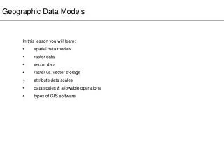
Objective • Organize environmentalandmeteorological data in a database withsupport for spatialextensions as vectorsandimages • Automating the estimation of evapotranspiration using remote sensing and GIS
Sensible Heat flux R n λET Soil heat flux The SEBAL algorithm As we saw last week • Is able to determine the components of surface energy balance using satellite imagery, wind data from meteorological station, size and crop coefficient (Kc), and other surface relief. λET = Rn - G - H
The SEBAL algorithm Satellite Data Images Rn G H Tar U100 Zref Zah r0 Processamento Tar U100 Zref Zah t0c Evapotranspiration Tar U100 Zref Zah Rg
Fast access However • The client wants to know directly how much the culture looses water, without having all the trouble of doing the calculation.
Fast access • For anoperationalinstitutethatreceives data andsatelliteimages, it`s interesting use a database thatsupportsmultipletypesof data andlargestoragecapacity; • Evapotranspiration is generatedondemandbytheclient via internet.
PostgreSQL • PostgreSQL is the system database open source world's most advanced, with a global community of thousands of users and developers, businesses and organizations.
PostgreSQL • The PostgreSQL project has more than 20 years of engineering, starting at the University of California, Berkeley, and an unparalleled development speed today.
PostgreSQL • The feature set of PostgreSQL not only equals that of database systems owners more advanced, but exceeds them in advanced features, extensibility, security and stability.
POSTGIS • PostGIS: It is a geospatial extension for postgresql; • PostGIS Guide : http://www.webgis.com.br/postgis/
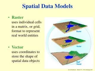
what is a spatial data? • The data that have location informationand vector or raster form. • Location of roads, rivers, lakes, LinesElectric Transmission, Forests, Parks,States, Cities. Also imagesrecorded by sensors.
Vector files • These entities are represented • as polygons. • as lines ; • as points and • Raster (satellite image)
Vector files • These entities are represented • as polygons. • as lines ; • as points and • Raster (satellite image)
Vector files • These entities are represented • as polygons. • as lines ; • as points and • Raster (satellite image)
Raster data • Satellite image • 16 bits • geottif • jpg
What kind of geometric objects can I store? Figura 1 – Um buffer circular(a)vetorial que intersecta com dois tipos de vegetação vetoriais (tipo 1 e tipo 2) com resultado em vetor. Operations: BUFFER(the_geo,distance); GEOMUNION(A.the_geom,B.the_geom); INTERSECTION(A.the_geom,B.the_geom); DIFFERENCE(A.the_geom,B.the_geom); CONVEXHULL(A.the_geom); DISTANCE (geometry a, geometry b); between 2 points. LENGTH(geometry); Lengthoftheline PERIMETER(g geometry); Perimeterofanpoligon. AREA(geometry); de um poligon.
What kind of geometric objects can I store? Operations: BUFFER(the_geo,distance); GEOMUNION(A.the_geom,B.the_geom); INTERSECTION(A.the_geom,B.the_geom); DIFFERENCE(A.the_geom,B.the_geom); CONVEXHULL(A.the_geom); DISTANCE (geometry a, geometry b); between 2 points. LENGTH(geometry); Lengthoftheline PERIMETER(g geometry); Perimeterofanpoligon. AREA(geometry); de um poligon.
What kind of geometric objects can I store? Operations: BUFFER(the_geo,distance); GEOMUNION(A.the_geom,B.the_geom); INTERSECTION(A.the_geom,B.the_geom); DIFFERENCE(A.the_geom,B.the_geom); CONVEXHULL(A.the_geom); DISTANCE (geometry a, geometry b); between 2 points. LENGTH(geometry); Lengthoftheline PERIMETER(g geometry); Perimeterofanpoligon. AREA(geometry); de um poligon.
What kind of geometric objects can I store? Operations: BUFFER(the_geo,distance); GEOMUNION(A.the_geom,B.the_geom); INTERSECTION(A.the_geom,B.the_geom); DIFFERENCE(A.the_geom,B.the_geom); CONVEXHULL(A.the_geom); DISTANCE (geometry a, geometry b); between 2 points. LENGTH(geometry); Lengthoftheline PERIMETER(g geometry); Perimeterofanpoligon. AREA(geometry); de um poligon.
EXAMPLES OF KINDS OF RELATIONS CROSS TOUCHES DISJOINT CONTAINS
EXAMPLE What are the states that border the state of Minas Gerais? SQL - Strucutred Query Language
Query the pixel value of the database via web Original data stored in postgresql
Example Query the pixel value of the database via web 26.3 ˚C
Materials & Methods The access is via Internet. Using Google maps interface with some features and tools to facilitate access and interaction with the system to obtain the final result (final product) – in other words the evapotranspiration.
Materials & Methods The access is via Internet. Using Google maps interface with some features and tools to facilitate access and interaction with the system to obtain the final result (final product) – in other words the evapotranspiration.
Materials & Methods The access is via Internet. Using Google maps interface with some features and tools to facilitate access and interaction with the system to obtain the final result (final product) – in other words the evapotranspiration.
Materials & Methods The access is via Internet. Using Google maps interface with some features and tools to facilitate access and interaction with the system to obtain the final result (final product) – in other words the evapotranspiration.
Materials & Methods weather station
Evapotranspiration cycle for fine weather conditions As an example, a farmer who has registered his farm in the National Supply Company (Conab). He must fill some fields as planting dates, crop planted, the farm area with geographic location, etc. (here in Brazil is starting the registration of agricultural areas with the use of GPS for production control)
References • REFERÊNCIA BIBLIOGRÁFICA • KOZIEVITCH, N. P. Dados meteorológicos: um estudo de viabilidade utilizando um SGBD em plataforma de baixo custo, dissertação de mestrado, Curitiba-PR, 2005, p.70. • OBE, REGINA. O.; HSU, LEO. S. PostGIS in Action: MEAP Edition Manning Early. Manning Publications Co. Acces Program. p. 425, ISBN: 9781935182269, May. 2009. Disponível em: <www.manning.com>. Acessado em: 10/01/2010. • POSTGIS MANUAL. Disponível em <http://postgis.refractions.net/docs/postgis.pdf>.Acesso em: 10/10/2009. • THE MAPSERVER TEAM. MapServer: MapServer documentation, Release 5.6.1, 2010, p. 714. • Ataide, K.R.P, Bezerra, W.A. - Dados Meteorológicos e Ambientais em PostgreSQL (PostGIS / WKT Raster) e consulta via WEB, XVI Congresso Brasileiro de Meteorologia, 2010, Belém-PA.
Thank you • Obrigado • Gracias • 谢谢 (xiè xiè) • شكرا(Shkrā) • Спасибо(Spasibo) • Dhanyavaadaalu • Eyalama