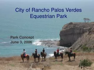
Download
1 / 2
20 likes | 148 Views
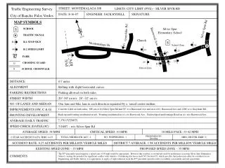
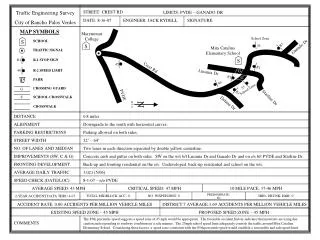
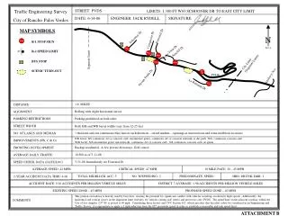
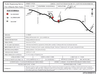
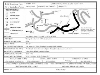
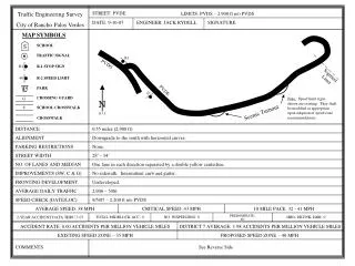
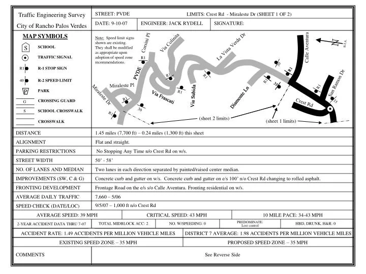
S. N. n.t.s. R1. R1. R1. 40. 35. 35. S. R1. R1. R1. 35. G. STREET: PVDE. Traffic Engineering Survey City of Rancho Palos Verdes. LIMITS: Crest Rd - Miraleste Dr (SHEET 1 OF 2). DATE: 9-10-07. ENGINEER: JACK RYDELL. SIGNATURE:. MAP SYMBOLS.

E N D
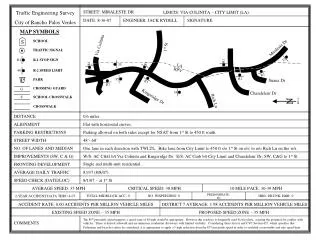
S N n.t.s. R1 R1 R1 40 35 35 S R1 R1 R1 35 G STREET: PVDE Traffic Engineering Survey City of Rancho Palos Verdes LIMITS: Crest Rd - Miraleste Dr (SHEET 1 OF 2) DATE: 9-10-07 ENGINEER: JACK RYDELL SIGNATURE: MAP SYMBOLS Note: Speed limit signs shown are existing. They shall be modified as appropriate upon adoption of speed zone recommendations. Corsini Pl Via Colinita La Vista Verde Dr SCHOOL Calle Aventura TRAFFIC SIGNAL R1 30 R-1 STOP SIGN PVDE PVDE R1 R1 R-2 SPEED LIMIT San Ramon Dr Miraleste Pl PARK R1 P Miraleste Dr Via Subida Via Subida Via Frascati Via Frascati Diamonte Ln Diamonte Ln R1 CROSSING GUARD Crest Rd 30 SCHOOL CROSSWALK (sheet 2 limits) (sheet 1 limits) CROSSWALK DISTANCE 1.45 miles (7,700 ft) – 0.24 miles (1,300 ft) this sheet ALIGNMENT Flat and straight. PARKING RESTRICTIONS No Stopping Any Time n/o Crest Rd on w/s. STREET WIDTH 50’ - 58’ NO. OF LANES AND MEDIAN Two lanes in each direction separated by painted/raised center median. IMPROVEMENTS (SW, C & G) Concrete curb and gutter on w/s. Concrete curb and gutter on e/s 100’ n/o Crest Rd changing to rolled asphalt. FRONTING DEVELOPMENT Frontage Road on the e/s s/o Calle Aventura. Fronting residential on w/s. AVERAGE DAILY TRAFFIC 7,660 – 5/06 9/5/07 – 1,000 ft n/o Crest Rd SPEED CHECK (DATE/LOC) AVERAGE SPEED: 39 MPH CRITICAL SPEED: 43 MPH 10 MILE PACE: 34-43 MPH TOTAL MIDBLOCK ACC: 2 NO. W/SPEEDING: 0 PREDOMINATE: Lost control HBD, DRUNK, H&R: 0 2-YEAR ACCIDENT DATA THRU 7-07 ACCIDENT RATE: 1.49 ACCIDENTS PER MILLION VEHICLE MILES DISTRICT 7 AVERAGE: 1.98 ACCIDENTS PER MILLION VEHICLE MILES EXISTING SPEED ZONE – 35 MPH PROPOSED SPEED ZONE – 35 MPH COMMENTS See Reverse Side
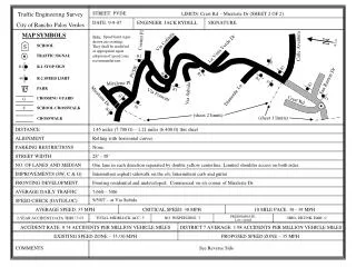
STREET: PVDE Traffic Engineering Survey City of Rancho Palos Verdes LIMITS: Crest Rd - Miraleste Dr (SHEET 1 OF 2) PROPOSED SPEED ZONE – 35 MPH • Comments: • This segment of roadway is generally characterized by one travel lane in each direction with substantial fronting single-family residential development and numerous sharp horizontal curves. In addition to driveway access, there are also several intersecting roadways, both public and private. It has been evaluated in two parts to acknowledge the distinctly different roadway characteristics on the short southern portion, between Crest Road and Calle Aventura, which is detailed on this sheet (sheet 1 of 2). This portion has two lanes in each direction, which is different from the rest of Palos Verdes Drive East. These additional travel lanes result in some motorists driving in a manner that can be unexpected to other motorists and in a manner that would be inappropriate for other portions of Palos Verdes Drive East. The southern portion constitutes only 0.24 miles of the segment’s 1.45 miles total length. The northern portion is 1.21 miles long and is detailed on sheet 2 of 2. • The California Manual of Uniform Traffic Control Devices (MUTCD), which is authorized by the California Vehicle Code (CVC) as the legal procedure for establishing speed zones, states that speed zones should not be less than 0.5 miles in length (see pages 2B-8 and 2B-10). Therefore, shorter portions must be combined into longer segments. The southern portion (sheet 1 of 2) has insufficient length to support a separate speed zone based on MUTCD procedures. In addition to the above MUTCD requirement, short speed zones are not appropriate due to their adverse effect on traffic safety by: • Increasing motorist confusion and potentially unexpected driver behavior due to changing traffic regulations; • Hampering enforcement efforts by issues associated with speed limit boundaries; and, • Increasing the potential for motorists to drive at different speeds, which increases conflict and accident potential. • One radar speed measurement was taken for this portion of the segment, with the 85th percentile speed suggesting that a speed zone of 45 mph would be appropriate and the potential application of an additional 5 mph reduction from the 85th percentile speed. However as detailed above, the extremely short length of this portion does not allow a separate speed zone from the adjacent segments. The segment to the south (from Crest Road southerly) is recommended at 35 mph, and the portion of this segment to the north, beginning at Calle Aventura and continuing to Miraleste Drive (comprising 83% of the total segment length) is also recommended for 35 mph. • Based on the procedures found in the MUTCD and the other factors identified above, it is inappropriate for this short stretch of roadway to have a separate speed zone from the adjacent segments. Therefore it should be combined with the portion to the north, creating a 35 mph speed zone between Crest Road and Miraleste Drive. This would result in a continuous 35 mph speed zone between the switchbacks (2,900 feet north of Palos Verdes Drive South) and Miraleste Drive.