Download
1 / 43
430 likes | 609 Views
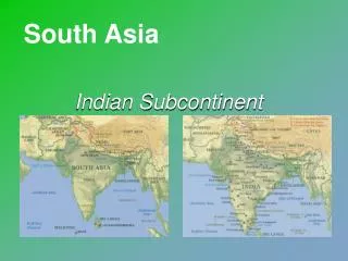
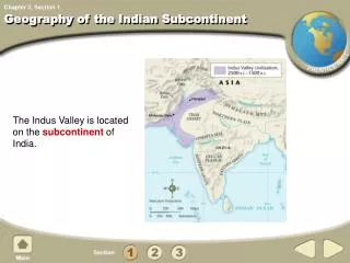
The Geography of the Indian subcontinent. Satellite View of South Asia. The Size of South Asia. Countries. Afghanistan. China. Iran. Bhutan. Nepal. Pakistan. Myanmar. India. Bangladesh. Sri Lanka. Bodies of Water. Indus R. Brahmaputra R. Ganges R. Bay of Bengal. Arabian Sea.

E N D
The Geography of the Indian subcontinent
Countries Afghanistan China Iran Bhutan Nepal Pakistan Myanmar India Bangladesh Sri Lanka
Bodies of Water Indus R. Brahmaputra R. Ganges R. Bay ofBengal Arabian Sea Indian Ocean
Landforms and Rivers • India is refer to often by geographers as a subcontinent • Subcontinent – a large landmass that is smaller than a continent • Subcontinents are usually separated from the rest of their continents by physical features • Mountains largely separate India from the rest of Asia • Among the mountains of northern India are the Himalayas, the highest mountains in the world • To the west are the Hindu Kush • Though these mountains made it hard to enter India, invaders have historically found a few paths through them
Hindu Kush Himalayas
The Ganges River System 1,560 miles long
Valleys / Plains Indo-GangeticPlain
Mountains & Peaks Hindu Kush KhyberPassI I Karakoran Mts. Mt. Everest▲ Himalayas Vindhya Hills Eastern Ghats Western Ghats
The Himalayas • “him” [snow] • “aalaya” [home] • Mt. Everest is 29,035 feet. It is the highest mt. peak in the world.
Deserts / Plateaus TibetanPlateau TharDesert DeccanPlateau
The Deccan Plateau • 31,800 square miles in size. • Elevation range: 2,000 – 8,000 feet high. • From the Sanskrit word, “dakshina” [“the south”].
The tibetan Plateau • The “Roof of the World.” • average elevation is 16,400 feet.
The Thar Desert • The Great Indian Desert • 200 - 1500 feet in elevation. • up to 127ºF in July.
Climate • Most of India has a hot and humid climate • This climate is heavily influenced by India’s monsoons • Monsoon – seasonal wind patterns that cause wet and dry seasons • In the summer, monsoon winds blow into India from the Indian Ocean, bringing heavy rains that can cause terrible floods • Some parts of India receive as much as 100 or even 200 inches of rain during this time • In the winter, winds blow down from the mountains • This forces moisture out of India and creates warm, dry winters
Harappan Civilization • Historians call the civilization that grew up in the Indus River Valley the Harappan civilization • In addition, many of the settlements were found along the Sarasvati River, located southeast of the Indus • Like other ancient societies we have studied, the Harappan civilization grew as irrigation and agriculture improved • As farmers began to produce surpluses of food, towns and cities appeared in India
India’s First Cities • The Harappan civilization was named after the modern city of Harappa, Pakistan • It was near this city that ruins of the civilization were first discovered • From studying these ruins, archaeologist think that the civilization thrived between 2300 and 1700 BC
The greatest sources of information we have about Harappan civilization are the ruins of two large cities, Harappa and MohenjoDaro • The two cities lay on the Indus more than 300 miles apart but were remarkably similar • Both were well planned • Each stood near a towering fortress • From these fortresses, defenders could look down on the cities’ brick streets, which crossed at right angles and were lined with storehouses, workshops, market stalls, and houses • Both cities had many public wells
Harappan Achievements • Harappan civilization was very advanced • Most houses had bathrooms with indoor plumbing • Artisans made excellent pottery, jewelry, ivory objects, and cotton clothing • They used high-quality tools and developed a system of weights and measures • They also developed India’s first writing system • Scholars have not yet learned to read this language, so we know very little about Harappan society • Historians think they had a kings and strong central governments, but aren’t sure • The people may have worshipped many gods • The civilization ended by the early 1700s, but no one is sure why
Aryan Migration • Not long after the Harappancivlization crumbled, a new group arrived in the Indus Valley • They were called the Aryans • They were originally from the area around the Caspian Sea in Central Asia • Over time, however, they became the dominant group in India
Arrival and Spread • The Aryans first arrived in India in the 2000s BC • Historians and archaeologist believe that the Aryans crossed into India through mountain passes in the northwest • Over many centuries, they spread east and south into central India • From there they moved even farther east into the Ganges River Valley • Much of what we know about the Aryan society comes from religious writings known as the Vedas • These are collections of poems, hymns, myths, and rituals that were written by Aryan priests
Government and Society • As nomads, the Aryans took along their herds of animals as they moved • But over time, they settled in villages and began to farm • Unlike the Harappans, they did not build big cities • The Aryan political system was also different from the Harappan system • The Aryans lived in small communities, based mostly on family ties • No single ruling authority existed • Each group had its own leader, often a skilled warrior
Aryan villages were governed by rajas • Rajas – a leader who ruled a village and the land around it • Villagers farmed some of this land for the raja • They used other sections as pastures for their cows, horses, sheep, and goats • Although many rajas were related, they didn’t always get along • Sometimes rajas joined forces before fighting a common enemy • Other times, however, rajas went to war against each other • In fact, Aryan groups fought each other nearly as often as they fought others
Answer these question in your notebook… • What are monsoons? • How does northern India differ from the rest of the region? • Why is India called a subcontinent? • Where did Harappan civilization develop? • What is one reason that scholars do not completely understand some important parts of Harappan society? • Who were the Aryans? • How was Aryan society different from Harappan society?