Download
1 / 50
500 likes | 626 Views
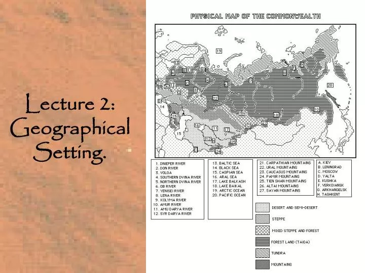
Lecture 2: Geographical Setting. 1. Geography. General Information. Coastlines. Most of its 26,000 miles of coastline is frozen over in the Baltic, Pacific, and Arctic coasts.

E N D
Coastlines. Most of its 26,000 miles of coastline is frozen over in the Baltic, Pacific, and Arctic coasts.
Frontiers. About 10,000 miles of land frontiers are shared borders with Norway, Finland, Ukraine, Belorus, Estonia, Latvia, Georgia, Azerbaijan, Lithuania, Romania, Turkey, Iran, China, Mongolia, and North Korea.
Size. It comprises 1/3 of Europe and 1/3 of Asia. Even with the loss of the other republics, Russia is still the largest country in the world in terms of territory.
Latitude. The Russia is more northerly in latitude than the U.S., most of its territory is north of the 50¡ parallel, while most U. S. Territory is south of the 50¡ parallel.
Latitude • Examples: • Archangel is the same latitude as Fairbanks, Alaska. • St. Petersburg is the same latitude as Labrador Island, Canada • Moscow is the same latitude as Sitka, Alaska • Kharkov is the same latitude as Vancouver, B.C., Canada • Yalta is the same latitude as Portland, Oregon
Longitude. Russia stretches from 20’ longitude to 170’ longitude, some 9,000 mile miles across 7 time zones.
Climate. The climate of the Russia and the C.I.S. is extreme continental. • Some examples: • Place Low High U. S. equivalent • Verkoiansk, Siberia -94F 85F N. Alaska/ Canada [F] • Moscow -45F 80's-90's Montana/ W. Canada [C] • Leningrad -35F 80's-90's Minnesota [B] • Tashkent 125F S. Nevada/Arizona
Desert & Semi-Desert. • Central Asia, S. Kazakhstan, north of the Caspian Sea. Similar to the American Southwest, especially parts of W. Texas, New Mexico, Arizona, Nevada, Utah.
B) Steppe. • Ukraine, Southern Volga region, Southern Siberia. Similar to the northern plain states and Canadian prairies (Ukrainians in Canada).
C) Mixed Steppe & Forest • Central European Russia, Belorus’, and the Southern Baltic. Similar to the Midwest and the Upper Mississippi valley (Minnesota, Wisconsin, etc.).
D) Taiga. • Dense forests of coniferous pine, fir and larch in the north, desiduous oak, elm, ash, birch in the south. Similar to the northern forestlands of the U.S. and Canada (Maine, Michigan, Washington, etc.)
. E) Tundra • Arctic and Sub-arctic marshland. Permafrost similar to northern reaches f Alaska, Canada, and Greenland.
III. Mountains. • Russia has no massive mountain range dividing the country like the Rockies in the U.S. and Canada.
A) The Urals. [22] • Russia does have an old range, the Urals, which separate European and Asiatic Russia, maximum height 6,214 ft. The Urals are similar to the U. S. Appalachians in their age and mineral resources--coal, iron, etc. Beginnings of Russian mineral industry. Other mountain ranges are mostly along the borders, and did not play a role in Russian history until the modern period.
B) The Carpathians. [21] • Shared with Romania, Czechoslovakia, Poland and Hungary. Ukrainian-speaking inhabitants--Hutsuls, Lemkos, etc. Soviet part known as the Trans-carpathian Region. Became part of the Soviet Union in 1945. Traditionally known as Sub Carpathian Ruthenia. Now part of Ukraine.
C) The Caucasus. [23] • Includes the Armenian and Pontic Highlands along the Turkish Border. Between the Black and Caspian Seas. Borders Turkey and Iran. Closest to our Rockies and the Swiss Alps. A rugged region inhabited by a host of peoples. Conquered in the 18th and 19th Centuries. Very difficult campaigns.
D) The Pamirs. [24] • Southern Central Asia. In Tadzhikistan (Iranian speaking). Borders Afghanistan and near Pakistan. The northern neighbor range of the Hindu Kush and Karakorum ranges. Captured in the mid- and late- 19th century.
E) The Tien Shan. [25] • Shared with China, in Kazakhstan and Sinxiang Province.
F) The Altai. [26] • Shared with Mongolia, in Southern Siberia and Kazakhstan.
G) The Sayan. [27] • A lower range along the Mongolian border to the east. In the Buriat region of Siberia.
H) The Siberian Upland Ranges. • Not large ranges extending to the Pacific.
IV. Rivers. • Unlike mountains, Rivers have been extremely important in Russian history. As our Hudson, Ohio, Mississippi and Missouri were to U. S. development.
The Dnieper. [1] • Source for the Black Sea trade in Medieval Times for Ukraine and Russia. Refuge for Cossacks. Used in Southern Expansion.
B) The Don. [2] • Source for the Black Sea trade in Medieval Times for Ukraine and Russia. Refuge for Cossacks. Used in Southern Expansion.
C) The Southern Dvina. [4] • Source for the Baltic Sea trade in Medieval Times for Ukraine and Russia. Used in Northwestern Expansion.
D) The Northern Dvina. [5] • Source for riverine transportation to arctic regions, important in the fur trade and eastward expansion. Archangel Port used for Trade with the west until opening of the Baltic.
E) The Volga.[3] • Southeastern Expansion. Source for the Baltic Sea trade in Medieval Times for Ukraine and Russia. Used in later expansion.
F) The Pechora. • Source for riverine transportation to arctic regions, important in the fur trade and eastward expansion.
G) The Ob. [7] • Source for riverine transportation to arctic regions, important in the fur trade and eastward expansion.
H) The Yenesei. [8] • Source for riverine transportation to arctic regions, important in the fur trade and eastward expansion.
The Lena. [9] • Source for riverine transportation to arctic regions, important in the fur trade and eastward expansion.
J) The Amu Darya. [11] • The ancient Jaxartes river, important in the oasis route in central Asia. Used in modern agriculture.
K) The Sir Darya. [12] • The ancient Oxus river, important in the oasis route in central Asia. Used in modern agriculture.
M) The Dniester. • Its capture important in Russian expansion against the Ottoman Empire.
N) The Pruth. • Its capture important in Russian expansion against the Ottoman Empire.
O) The Danube. • Important since 1945. Romania and Moldova control the mouth of the Danube.
VI. Oceans,Seas, &Lakes. • These bodies of water have become important in Russian History since the 18th cenutry, with the advent of Russia as a maritime and naval power.
The Arctic Ocean. [19] • Important as first seaport, Archangel in early modern times. Became more important later with the development of Icebreakers.
B) The Pacific Ocean. [20] • Reached by the Russians in their eastward expansion in the late 17th Century. Became important with the annexation of the Maritime provinces in the 1860's and the development of Vladivostok.
C) The Baltic Sea. [13] • Very important in medieval period, Novgorod was terminus of Hanseatic league. Became very important in early modern times struggle with Sweden and Poland over Baltic. Founding of St. Petersburg and annexation of Latvia, Lithuania and Estonia, part of drive for warm water ports.
D) The Black Sea. [14] • Very important in medieval period, trade with Byzantium, and Mediterranean. Became very important in early modern times struggle with Ottoman Empire over Black Sea. Annexation of Crimea, Southern Ukraine and Caucasus part of drive for warm water ports. Black Sea trade outlet to Mediterranean.
E) The Caspian Sea. [15] • Very important in medieval period, trade with Islamic East, and Central Asia. Became very important in early modern times struggle with Persia over Black Sea. Annexation of northern Caspian part of drive for warm water ports.
F) The Aral Sea. [16] • In Central Asia. Problems with loss of water and pollution.
G) Lake Baikal. [18] • In Siberia. Like Lake Tahoe. The Deepest lake in the World. Problems with pollution
VII. Conclusions. Similarities to the U.S. Rivers, plains, Urals, etc.