Download
1 / 18
180 likes | 296 Views
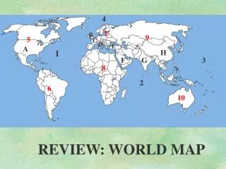
Map and Globe Review. What is a round model of the Earth called?. Answer: a globe. Name the four cardinal directions. Answer: North, South, East and West. What is the imaginary line that separates the northern and southern hemispheres called?. Answer: the equator. Name the 7 continents.

E N D
What is a round model of the Earth called? Answer: a globe
Name the four cardinal directions. Answer: North, South, East and West
What is the imaginary line that separates the northern and southern hemispheres called? Answer: the equator
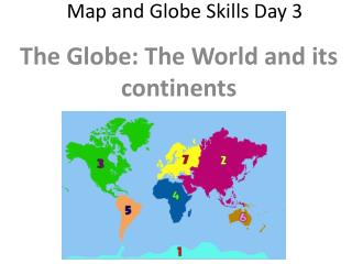
Name the 7 continents • Answer: North America, South America, Europe, Asia, Australia, Antarctica and Africa
Name the four oceans. • Answer: Atlantic Ocean, Pacific Ocean, Indian Ocean and Arctic Ocean
Which 2 hemispheres does the prime meridian divide the Earth into? Answer: Eastern and Western Hemispheres
What is half a sphere called? Answer: a hemisphere
One of the Earth’s seven great bodies of land is called a ____________. Answer: continent
What is the imaginary line that separates the eastern and western hemispheres called? Answer: Prime Meridian
Which map shows information such as cities, capitals, states, and countries? Answer: Political Map
Which map shows information about past events and where they occurred? Answer: Historical Map
Which map shows natural features of the Earth? Answer: Physical Map
What shows the relationship between distances on a map and actual distances? Answer: scale
What explains what each symbol on a map stands for? (It goes by two names.) Answer: Map Key or Legend
A picture of the Earth’s surface that shows the distance, direction, and size of a place is called a ____________. Answer: map
A person who makes map is called a ___________. Answer: Cartographer
Bonus: What hemispheres do we live in? Answer: Northern and Western Hemisphere