Download
1 / 58
580 likes | 724 Views
Overview of the Rapid Refresh RAP. NOAA/ESRL/GSD/ Assimilation and Modeling Branch RAP development scientists Stan Benjamin Steve Weygandt Ming Hu / Tanya Smirnova Curtis Alexander / John M. Brown David Dowell / Joe Olson Bill Moninger / Haidao Lin Georg Grell / David Dowell

E N D
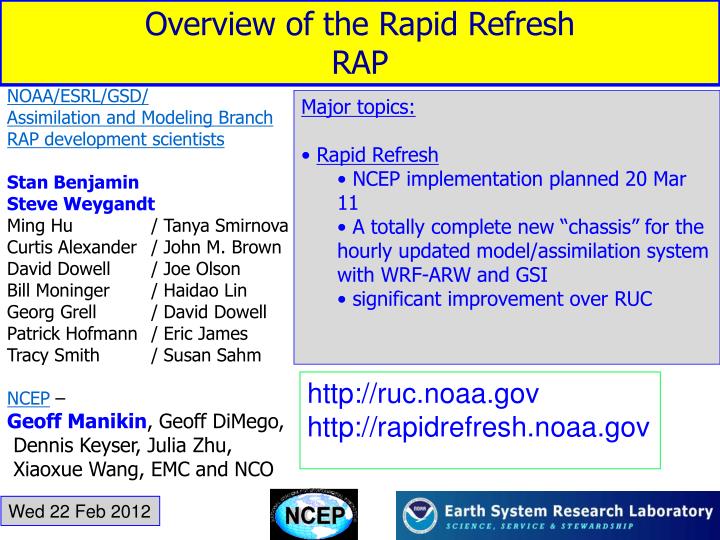
Overview of the Rapid Refresh RAP NOAA/ESRL/GSD/ Assimilation and Modeling Branch RAP development scientists Stan Benjamin Steve Weygandt Ming Hu / Tanya Smirnova Curtis Alexander / John M. Brown David Dowell / Joe Olson Bill Moninger / Haidao Lin Georg Grell / David Dowell Patrick Hofmann / Eric James Tracy Smith / Susan Sahm NCEP – Geoff Manikin, Geoff DiMego, Dennis Keyser, Julia Zhu, Xiaoxue Wang, EMC and NCO • Major topics: • Rapid Refresh • NCEP implementation planned 20 Mar 11 • A totally complete new “chassis” for the hourly updated model/assimilation system with WRF-ARW and GSI • significant improvement over RUC http://ruc.noaa.gov http://rapidrefresh.noaa.gov Wed 22 Feb 2012
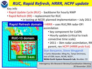
Hourly Updated NOAA NWP Models Rapid Refresh (RAP or RR) replaces RUC at NCEP WRF, GSI with RUC features 13km Rapid Refresh 13km RUC RUC – current oper model, new 18h fcst every hour
RUC Non-WRF RUC model RUC 3DVAR analysis 24/Day = hourly update Forecasts to 18 hours 13 km horizontal Rapid Refresh WRF-based ARW GSI analysis Expanded 13 km Domain ~2.8 times bigger Includes Alaska Experimental 3 km HRRR runs ONLY at ESRL currently RUC Becomes Rapid Refresh Rapid Refresh domain RUC-13 CONUS domain RUC domain
Guide to different versions of Rapid Refresh • NCEP version (like your first iPhone) • Topic of this briefing • Planned for implementation on 20 March 2012 • Improvement over RUC but a “little older” • ESRL version (like iPhone4?) • Initializes the HRRR • Testing “version 2” of RAP now, implementation @NCEP in 8-12 months (hopefully earlier) • Key further improvements for convective environment
Outline • Model description for Rapid Refresh • Data assimilation description for RAP • Output from RAP (grids, Unipost mods, RTMA, BUFR) • Partial cycling for Rapid Refresh, SST, land-surface grids • Verification statistics for RAP vs. RUC
WRF model enhancements for Rapid Refresh • WRF - ARW - v3.2.1+ for initial RAP • WRF v3.3 issued too late in April 2011 – NCEP code freeze • Benefited from ongoing community improvements to WRF • GSD improvements – • Digital filter initialization (DFI - allows quiet 1h forecasts) • DFI-radar • Grell 3-d cumulus • RUC LSM (now with snow LSM cycling on sea ice) • Use of rotated lat-lon grid - GSD was first to use ARW with RLL
Transition from RUC to Rapid Refresh Provides hourly cycled guidance to all North America Community-based advanced model and analysis - WRF-ARW: advanced numerics, non-hydrostatic - GSI: advanced satellite data assimilation
Rapid Refresh sigma levels (50) 1.0000, 0.9980, 0.9940, 0.9870, 0.9750, 0.9590, 0.9390, 0.9160, 0.8920, 0.8650, 0.8350, 0.8020, 0.7660, 0.7270, 0.6850, 0.6400, 0.5920, 0.5420, 0.4970, 0.4565, 0.4205, 0.3877, 0.3582, 0.3317, 0.3078, 0.2863, 0.2670, 0.2496, 0.2329, 0.2188, 0.2047, 0.1906, 0.1765, 0.1624, 0.1483, 0.1342, 0.1201, 0.1060, 0.0919, 0.0778, 0.0657, 0.0568, 0.0486, 0.0409, 0.0337, 0.0271, 0.0209, 0.0151, 0.0097, 0.0047, 0.0000, 4 layers in lowest 200m, lowest @ ~8m WRF default choices for sigma levels (35) 1.000, 0.993, 0.983, 0.970, 0.954, 0.934, 0.909, 0.880, 0.845, 0.807, 0.765, 0.719, 0.672, 0.622, 0.571, 0.520, 0.468, 0.420, 0.376, 0.335, 0.298, 0.263, 0.231, 0.202, 0.175, 0.150, 0.127, 0.106, 0.088, 0.070, 0.055, 0.040, 0.026, 0.013, 0.000 3 layers in lowest 200m, lowest @~50m
Rapid Refresh GSI-based Hourly Assimilation Cycle GSI GSI Obs Obs Hourly obs Data Type ~Number/hr Rawinsonde (12h) 120 NOAA profilers 21 VAD winds ~125 PBL – profiler/RASS ~25 Aircraft (V,temp) 2K-15K(avg 7K) WVSS (RH) 0-800(avg 520) Surface/METAR ~2500 Buoy/ship 200-400 GOES cloud winds 4000-8000 GOES cloud-top pres 10 km res GPS precip water ~260 Mesonet (temp, dpt) ~8000 (RRv2) Mesonet (wind) ~4000 (RRv2) METAR-cloud-vis-wx ~2000 AMSU-A/B/HIRS/etc. radiances GOES radiances - in testing – RRv2 Radar reflectivity 1km Lightning (proxy refl) (RRv2) Radar radial wind - in testing - RRv2 Nacelle/tower/sodar (future) Cycle hydrometeor, soil temp/moisture/snow 1-hr fcst 1-hr fcst 1-hr fcst Background Fields Analysis Fields Time (UTC) 11 12 13
Diabatic Digital Filter Initialization Reduce noise in RUC and Rapid Refresh Noise parameter
Radar reflectivity assimilation Digital Filter-based reflectivity assimilation initializes ongoing precipitation regions -20 min -10 min Initial +10 min + 20 min Backwards integration, no physics Forward integration,full physics with radar-based latent heating Initial fields with improved balance, storm-scale circulation RUC / RAP HRRR model forecast + RUC/RAP Convection suppression
Rapid Refresh (GSI + ARW) reflectivity assimilation example Upper-level Divergence Low-level Convergence NSSL radar reflectivity (dBZ) K=17 U-comp. diff (radar - norad) K=4 U-comp. diff (radar - norad) 14z 22 Oct 2008 Z = 3 km
Rapid Refresh – specific analysis features Cloud and hydrometeor analysis Special treatments for surface observations Digital filter-based reflectivity assimilation
Rapid Refresh – specific analysis features Cloud and hydrometeor analysis Cloud and hydrometeor analysis UPDATE: No cloud building from NESDIS/ Langley cloud products in initial RAP (RUC experiments, bring in with RAP2. (GOES cloud building re-enabled in ESRL RAP/HRRR - 2/15/12)
Outline • Model description for Rapid Refresh • Data assimilation description for RR (RAP) • Output from RAP (grids, Unipostmods, RTMA, BUFR) • Partial cycling for Rapid Refresh, SST, land-surface grids • Verification statistics for RAP vs. RUC
Rapid Refresh NCEP planned grid distribution • RAP grid distribution from NCEP will include: • 130 (13 km CONUS): pgrb, bgrb • 252 (20 km CONUS): pgrb, bgrb • 236 (40 km CONUS): pgrb • 242 (11 km Alaska): one file with all needed parameters • 221 (32 km nearly full domain): one file with all needed parameters • (NOTE: Full NAM grid is also on 221 grid) • 200 (12km Puerto Rico) - single output file • Additional grid not to be distributed initially due to bandwidth limitation • 83 (13km full Rapid Refresh domain on rotated lat/lon grid) http://rapidrefresh.noaa.gov
AK grid Grid 242 RR full Grid 83 RUC full Grid 130 PR Grid 200 NA grid Grid 221
Unipost options added for Rapid Refresh application • Ceiling -includes NCAR code for effect of falling snow • Visibility -includes RH component and updated coefficients from NCAR • Now used by Binbin Zhou for SREF • MAPS SLP reduction – more coherent SLP pattern over elevated terrain, matches RUC output SLP • Precip-type – based on explicit qi/qc/qr/qs/qg • Heights for ARW input • Switch to virtual temp for CAPE/CIN, others • All commits into NCEP Unipost repository http://rapidrefresh.noaa.gov
Other post-processing, NARRE-TL • BUFR soundings • Downscaling for RTMA background • RAP replacing RUC • GEMPAK grids • for SPC, AWC, HPC • Hourly updated regional ensemble with RAP and NAM time-lagged ensemble members • Formerly known as VSREF (very short range) • Official name – NARRE-TL – N. American Rapid Refresh Ensemble – Time-lagged http://rapidrefresh.noaa.gov
Outline • Model description for Rapid Refresh • Data assimilation description for RAP • Output from RAP (grids, Unipost mods, RTMA, BUFR) • Partial cycling for Rapid Refresh, SST now using RTG_SST_HR-12km • Verification statistics for RAP vs. RUC
Rapid Refresh Partial Cycling GFS model GFS model RR spin-up cycle RR spin-up cycle Observation assimilation 00z 03z 06z 09z 12z 15z 18z 21z 00z Observation assimilation RR Hourly cycling throughout the day - Hourly cycling of land surface model fields - 6 hour spin-up cycle for hydrometeors, surface fields
Hurricane Irene RUC 18h 989 hPa RAP 18h 952 hPa Obs 15z Sat 27 Aug 2011 967 hPa • RAP partial cycling with GFS inserted 2x/day very helpful for tropical cyclones in RAP, which then spins down TCs to 13km horizontal resolution. • RAP will be much better background for RTMA for TCs
Outline • Model description for Rapid Refresh • Data assimilation description for RAP • Output from RAP (grids, Unipost mods, RTMA, BUFR) • Partial cycling for Rapid Refresh, SST now using RTG_SST_HR-12km • Case studies and verification statistics for RAP vs. RUC
Rapid Refresh Wind forecast accuracy vs. forecast length 12 6 3 1h 18h March 2011 The Rapid Refresh isable to use recent obs to improve forecast skill down to 1-h projection
Raob verification: RUC-NCEP vs. RAP-NCEP(EMC) 12h fcst RUC RR RUC RAP RAP better RUC better RAP better RUC better 12h Wind – rms vector error 24Oct - 20Nov 2011 12h Temp – rms error 24Oct - 20Nov 2011 RAP RUC
12h fcst RUC RAP Height – rms 1-30 Jan 2012 RAP RUC RAP better RUC better Height –bias 1-30 Jan 2012 RAP RUC
Rapid Refresh (NCO) vs.RUC(oper) upper-air verification DIFF wind RAP + 6h forecast RMS Error RUC 9 – 30Jan 2012 DIFF Rel Hum DIFF RAP Temp. RUC RAP better RUC better
Rapid Refresh (NCO) vs.RUC(oper) upper-air verification DIFF Wind RAP +12h forecast RMS Error RUC 9 – 30Jan 2012 DIFF Rel Hum DIFF RAP Temp. RUC
+ 12h forecast Temp rms error Rapid Refresh (NCO) vs.RUC(oper) upper-air verification 9 Jan – 22 Feb 2012 RUC RUC RAP RAP RAP better RUC better RAP better RUC better Over full RUC CONUS domain Over eastern US only
+ 12h forecast Temperature bias Valid 0z only Rapid Refresh (NCO) vs.RUC(oper) upper-air verification 23 Jan – 22 Feb 2012 RUC RUC RAP RAP Over full RUC CONUS domain Over eastern US only
+ 12h forecast Temperature bias Valid 12z only Rapid Refresh (NCO) vs.RUC(oper) upper-air verification 23 Jan – 22 Feb 2012 RUC RUC RAP RAP Over full RUC CONUS domain Over eastern US only
Sample RAP and RUC sounding structure RAP RUC 12z 2 Feb FWD (from SPC)
Sample RAP sounding structure 12z 1 Feb FWD (from SPC)
RAP vs. RUC Precipitation Verification RAP CSI (x 100) 13-km CONUS Comparison 2 X 12 hr fcst vs. CPC 24-h analysis 1 May – 15 July 2011 Matched RUC | | | | | | | | 0.01 0.10 0.25 0.50 1.00 1.50 2.00 3.00 in. RAP bias (x 100) 100 (1.0) RUC SPRING/ SUMMER | | | | | | | | 0.01 0.10 0.25 0.50 1.00 1.50 2.00 3.00 in.
observed RAP vs. RUC 24-h precip. verif 2 x 12h fcst ending 12z 21 June 2011 Interpolated to 20-km grid CPC 24-h precip RUC RAP Thrs CSI Bias 1.00 .31 0.69 2.00 .21 0.58 Thrs CSI Bias 1.00 .45 1.22 2.00 .29 1.95
observed RAP vs. RUC 24-h precip. verif 2 x 12h fcst ending 12z 21 June 2011 Interpolated to 20-km grid CPC 24-h precip Miss FA Hit RUC 1” theshold RAP Thrs CSI Bias 1.00 .31 0.69 2.00 .21 0.58 Thrs CSI Bias 1.00 .45 1.22 2.00 .29 1.95
RAP vs. RUC surface – warm season Diurnal bias variation 6-h fcst COLD WARM RUC daytime slightly cool, RAP warm, esp. overnight Both too moist, especially at night RUC worse than RAP RAP RUC 2m Temperature (K) RUC RAP LOW HIGH 2m Dew Point (m/s) 2-month comparison 20 April – 20 July 2011 Eastern US only
RAP vs. RUC surface – cold season Diurnal bias variation 6-h fcst 2m Temper- ature (K) COLD WARM RUC daytime quite cool, RR good Both too moist, especially during day RAP RUC RUC RAP LOW HIGH 2m Dew Point (m/s) 3-week comparison 9 – 30 Jan 2012 Eastern US only
RAP – smoother SLP Geoff Manikin’s RAP vs. RUC web page http://www.emc.ncep.noaa.gov/mmb/gmanikin/rap/para/
Reflectivity • RAP – • more coverage over Gulf of Mexico (in this case – slightly higher SST?, • better maintenance of areas of moisture
Snow cover • RAP – • Melting is slightly faster than in RUC (mods to RUC LSM) (less LES coverage in PA/OH) • Less excessive springtime snow cover • Now can handle snow cover over ice (note w. Lake Erie, Saginaw Bay, Hudson Bay)
Faster snow melt in RAP than RUC More realistic 2m temp over snow in RAP Tues 21 Feb 2012 case
Faster snow melt in RAP than RUC More realistic 2m temp over snow in RAP Tues 21 Feb 2012 case
Faster snow melt in RAP than RUC More realistic 2m temp over snow in RAP Tues 21 Feb 2012 case
Higher resolution SST data in RAP – 4km vs. RUC - 24km