Download
1 / 1
20 likes | 150 Views
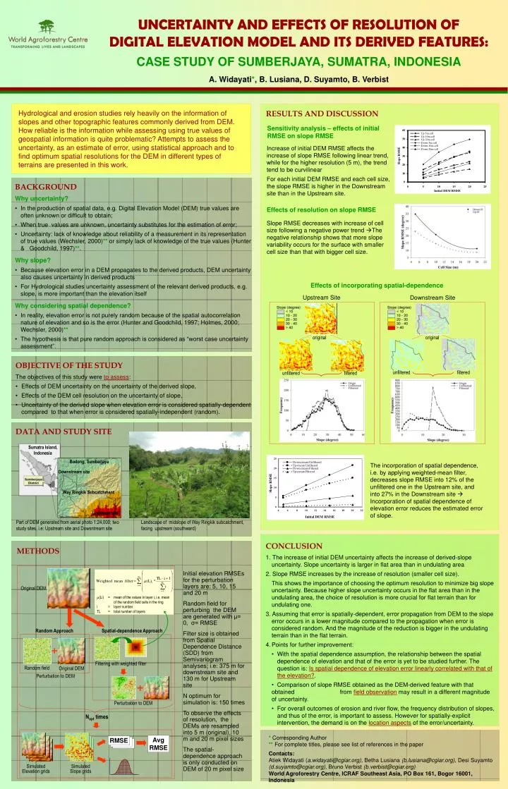
Sensitivity analysis – effects of initial RMSE on slope RMSE. 60. Up 5m cell. Up 10m cell. 50. Up 20m cell. Down 5m cell. Down 10m cell. 40.

E N D
Sensitivity analysis – effects of initial RMSE on slope RMSE 60 Up 5m cell Up 10m cell 50 Up 20m cell Down 5m cell Down 10m cell 40 Increase of initial DEM RMSE affects the increase of slope RMSE following linear trend, while for the higher resolution (5 m), the trend tend to be curvilinear For each initial DEM RMSE and each cell size, the slope RMSE is higher in the Downstream site than in the Upstream site. Down 20m cell Slope RMSE 30 20 10 0 0 5 10 15 20 25 Initial DEM RMSE Effects of resolution on slope RMSE Slope RMSE decreases with increase of cell size following a negative power trend The negative relationship shows that more slope variability occurs for the surface with smaller cell size than that with bigger cell size. Upstream Site Downstream Site original original unfiltered filtered unfiltered filtered Sumatra Island, Indonesia Bodong, Sumberjaya Downstream site Way Ringkik Subcatchment Upstream site (Li) = mean of the values in layer i, i.e. mean of the random field cells in the ring i = layer number TL = total number of layers Random Approach Spatial-dependence Approach RMSE UNCERTAINTY AND EFFECTS OF RESOLUTION OF DIGITAL ELEVATION MODEL AND ITS DERIVED FEATURES: CASE STUDY OF SUMBERJAYA, SUMATRA, INDONESIA A. Widayati*, B. Lusiana, D. Suyamto, B. Verbist Hydrological and erosion studies rely heavily on the information of slopes and other topographic features commonly derived from DEM. How reliable is the information while assessing using true values of geospatial information is quite problematic? Attempts to assess the uncertainty, as an estimate of error, using statistical approach and to find optimum spatial resolutions for the DEM in different types of terrains are presented in this work. RESULTS AND DISCUSSION • BACKGROUND • Why uncertainty? • In the production of spatial data, e.g. Digital Elevation Model (DEM) true values are often unknown or difficult to obtain; • When true values are unknown, uncertainty substitutes for the estimation of error; • Uncertainty: lack of knowledge about reliability of a measurement in its representation of true values (Wechsler, 2000)** or simply lack of knowledge of the true values (Hunter & Goodchild, 1997)**. • Why slope? • Because elevation error in a DEM propagates to the derived products, DEM uncertainty also causes uncertainty in derived products • For Hydrological studies uncertainty assessment of the relevant derived products, e.g. slope, is more important than the elevation itself • Why considering spatial dependence? • In reality, elevation error is not purely random because of the spatial autocorrelation nature of elevation and so is the error (Hunter and Goodchild, 1997; Holmes, 2000; Wechsler, 2000)** • The hypothesis is that pure random approach is considered as “worst case uncertainty assessment”. Effects of incorporating spatial-dependence • OBJECTIVE OF THE STUDY • The objectives of this study were to assess: • Effects of DEM uncertainty on the uncertainty of the derived slope, • Effects of the DEM cell resolution on the uncertainty of slope, • Uncertainty of the derived slope when elevation error is considered spatially-dependent compared to that when error is considered spatially-independent (random). DATA AND STUDY SITE The incorporation of spatial dependence, i.e. by applying weighted-mean filter, decreases slope RMSE into 12% of the unfiltered one in the Upstream site, and into 27% in the Downstream site Incorporation of spatial dependence of elevation error reduces the estimated error of slope. Part of DEM generated from aerial photo 1:24,000; two study sites, i.e: Upstream site and Dowsntream site Landscape of midslope of Way Ringkik subcatchment, facing upstream (southward) • CONCLUSION • 1. The increase of initial DEM uncertainty affects the increase of derived-slope uncertainty. Slope uncertainty is larger in flat area than in undulating area • 2. Slope RMSE increases by the increase of resolution (smaller cell size). • This shows the importance of choosing the optimum resolution to minimize big slope uncertainty. Because higher slope uncertainty occurs in the flat area than in the undulating area, the choice of resolution is more crucial for flat terrain than for undulating one. • 3. Assuming that error is spatially-dependent, error propagation from DEM to the slope error occurs in a lower magnitude compared to the propagation when error is considered random. And the magnitude of the reduction is bigger in the undulating terrain than in the flat terrain. • Points for further improvement: • • With the spatial dependence assumption, the relationship between the spatial dependence of elevation and that of the error is yet to be studied further. The question is: Is spatial dependence of elevation error linearly correlated with that of the elevation?. • • Comparison of slope RMSE obtained as the DEM-derived feature with that obtained from field observation may result in a different magnitude of uncertainty. • • For overall outcomes of erosion and river flow, the frequency distribution of slopes, and thus of the error, is important to assess. However for spatially-explicit intervention, the demand is on the location aspects of the error/uncertainty. METHODS Initial elevation RMSEs for the perturbation layers are: 5, 10, 15 and 20 m Random field for perturbing the DEM are generated with μ= 0, σ= RMSE Filter size is obtained from Spatial Dependence Distance (SDD) from Semivariogram analyses; i.e: 375 m for downstream site and 130 m for Upstream site N optimum for simulation is: 150 times To observe the effects of resolution, the DEMs are resampled into 5 m (original), 10 m and 20 m pixel sizes The spatial-dependence approach is only conducted on DEM of 20 m pixel size Original DEM Filtering with weighted filter Random field Original DEM Perturbation to DEM Perturbation to DEM Nopt times *Corresponding Author ** For complete titles, please see list of references in the paper Contacts: Atiek Widayati (a.widayati@cgiar.org), Betha Lusiana (b.lusiana@cgiar.org), Desi Suyamto (d.suyamto@cgiar.org), Bruno Verbist (b.verbist@cgiar.org) World Agroforestry Centre, ICRAF Southeast Asia, PO Box 161, Bogor 16001, Indonesia Avg RMSE Simulated Elevation grids Simulated Slope grids