Download
1 / 36
360 likes | 458 Views
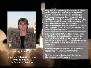
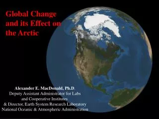
Keynote Address: NOAA, GEOSS, and Cal/Val. Mary Kicza Deputy Assistant Administrator for Satellite and Information Services National Oceanic and Atmospheric Administration Workshop on Achieving Satellite Instrument Calibration for Climate Change National Conference Center Lansdowne, VA

E N D
Keynote Address: NOAA, GEOSS, and Cal/Val Mary Kicza Deputy Assistant Administrator for Satellite and Information Services National Oceanic and Atmospheric Administration Workshop on Achieving Satellite Instrument Calibration for Climate Change National Conference Center Lansdowne, VA May 16, 2006
NOAA’s Mission • To describe and predict changes in the Earth’s environment. • To conserve and manage the Nation’s coastal and marine resources to ensure sustainable economic opportunities.
NOAA Data and Information are Essential for… Ocean Climate Hazards, Severe Weather, Watches, Warnings Transportation Defense Industry Environmental Monitoring Agriculture Commerce
Has Observing Instruments On Land, Ocean, Air, And Space Space-Based Ocean-Based Land-Based Air-Based
Provides Aerial Surveys and Navigation Response to Survey Channels for Debris Hurricane Katrina
Monitors the Population of Endangered Species and Stellar Seal Lion
Provides Support to FAA for Volcanic Ash Alerts NOAA-15 color enhanced image
NOAA’s El Niño Forecast Resulted In Worldwide Agricultural Benefits Of At Least $450 Million Improved El Niño Forecasts Benefit U.S. Agriculture An Estimated $265 - $300 Million Annually El Niño Forecasts Localized Changes In Ocean Temperatures (El Niño) Have A Major Impact On Climate And Weather
Floods Account For $5.2 Billion In Damages, And Average Over 80 Deaths Per Year Hurricanes Cause an Average of $5.1 Billion In Damages, And 20 Deaths Per Year Hurricane Isabel Left 27 Dead In 7 States And 3.3 Million People Without Electrical Power
NOAA Satellites View smoke plumes From World Trade Center September 11, 2001 NOAA polar satellite image At 5 pm EDT 9/11 showing plume GOES captured the plume Within minutes of the incident
NOAA’s Operational Environmental Satellites NOAA provides an OPERATIONAL remote sensing capability for acquiring and disseminating GLOBAL and regional imagery and measurements of the environment, including METEOROLOGICAL, CLIMATIC, OCEANOGRAPHIC,SOLAR-GEOPHYSICAL, and HAZARDS data, in support of the NOAA mission and the benefit of the Nation.
Launch Command & Control Acquisition Requirements & Planning Real-Time Product Development Archive & Access Assessments User Services An End-to-End Responsibility
National Investment The U. S. has made and continues to make investments in civil operational satellites observing systems. Such systems allow us to describe understand forecast assess the earth and its environment
Geostationary Operational Environmental Satellites (GOES) and GOES-R Polar-Orbiting Operational Environmental Satellite (POES) National Polar-orbiting Operational Environmental Satellite System (NPOESS) Processing/distribution of non-NOAA satellite data DMSP, International geostationary satellites, QuikSCAT, TOPEX, ERS-2, EOS Terra and Aqua, SeaWIFS Environmental Data Management National Climatic Data Center National Oceanographic Data Center National Geophysical Data Center Applications Research and Development Joint NOAA/NASA/DoD Satellite Data Assimilation Center NOAA Programs that Support Monitoring the Earth-Climate System
Atmospheric Products: Examples Winds Total Water Vapor Temperature500 mb Ozone Rain Rate Aerosol Optical Thickness
Ocean Products: Examples SST Anomalies Hot Spots: Potential Coral Bleaching TOPEX Sea Level Sea WIFS Ocean Color QuikSCAT Winds
Land Surface Products: Examples Vegetation Health Snow QuebecFires/Smoke Solar Radiation Global Lights/Fires
Satellite Continuity 99 00 01 02 03 04 05 06 07 08 09 10 11 12 13 14 15 16 17 18 19 20 21 CY Polar 0530 NPOESS DMSP WindSat 0730 NPOESS DMSP METOP POES Local Equatorial Crossing Time 1030 Terra Future Systems NPP 1330 C2 or C1 NPOESS POES Aqua Geostationary GOES GOES – R Series Meteosat 2nd Generation Meteosat GIFTS/IOMI ?
Integrated Global U.S. GOES India INSAT Sustained Attributes of an Integrated Global Observing System Comprehensive
President’s Statement Our cooperation will enable us to develop the capability to predict droughts, prepare for weather emergencies, plan and protect crops, manage coastal areas and fisheries, and monitor air quality
Group on Earth Observations (GEO) • Membership open to all countries • 60 countries (including the EC) are now represented • International organizations are participants • 43 organizations are now represented • Organized into 5 subgroups • Established GEO Secretariat • Established Implementation Plan Task Team
GEO Moves ForwardWorking Towards Implementation of the Global Observation System of Systems (GEOSS) • Received approval for formal GEO organization and 10-year implementation plan • Held GEO-I in May 2005, and GEO-II in December 2005 • New GEO Secretariat Director, Jose Achache • Agreed to 2006 Work Plan and adopted a budget • Formally created GEO Committees • GEONETCast as tangible near term project to implement GEOSS • US announced intention to move GOES satellite over South America to help offset lack of sounder data in that region
Global Earth Observation System of SystemsIntegrated Observations & Data Management Intercalibration of foreign and domestic satellites is fundamental to GEOSS
Societal Benefit Areas • Improve Weather Forecasting • Reduce Loss of Life and Property from Disasters • Protect and Monitor Our Ocean Resources • Understand, Assess, Predict, Mitigate, and Adapt to Climate Variability and Change • Support Sustainable Agriculture and Combat Land Degradation • Understand the Effect of Environmental Factors on Human Health and Well-Being • Develop the Capacity to Make Ecological Forecasts • Protect and Monitor Water Resources • Monitor and Manage Energy Resources
Satellite Observations Have Contributed to More Accurate Weather Forecasts • Southern Hemisphere forecasts are now as accurate as NH forecasts • Today’s 5-day forecasts as accurate as 3-day forecasts 25 years ago • BUT…..forecast centers remove satellite biases approximately and empirically • Improved calibration and intercalibration can be expected to lead to further gains in forecast accuracy ECMWF
Satellite Observations Have Contributed to Improved Monitoring of Global Climate Change One Example: May 3, 2006 Federal Study Finds Accord on Warming By ANDREW C. REVKIN A scientific study commissioned by the Bush administration concluded yesterday that the lower atmosphere was indeed growing warmer …… Above conclusion based on careful analyses of NOAA’s MSU observations (one analysis is shown on right) But enormous challenges remain in monitoring global climate change MSU Tropospheric Temp Anomaly (C) (U. Alabama)
Challenges in Monitoring Global Climate Change from Space Total Solar Irradiance • Need to construct time series by stitching together observations of many satellites • Extremely small signals • Atmospheric temperature trends as small as 0.1 C/decade • Ozone changes as little as 1%/decade • Variations in the sun’s output as tiny as -0.02%/decade • Different analyses of observations vary from: -0.023 to +0.25 W/m2 • Good calibration and intercalibration are crucial (Wilson, 03) (After Frohlich)
Is the Earth Greening? Equator Crossing Time • NOAA’s AVHRRs have been used to construct a time series of Vegetation Index that indicates a greening Earth – but we don’t know if this is really happening because of uncertainties in calibration and intercalibration of the different satellites • Good calibration and intercalibration are crucial Pinatubo eruption (After Heidinger)
Next Steps:NOAA/NIST Initiative in Satellite Calibration and Intercalibration • A Government program is needed to assure instruments meet specification and pre-launch tests are traceable to SI standards, and the on-orbit satellite instrument observations are well calibrated and validated by means of careful analysis of instrument performance, satellite intercalibration and validation with reference sites • On-orbit validation is needed for foreign satellite instruments to meet GEOSS objectives • Inadequate calibration can result in economic benefit losses in the billion dollar range. • Degraded climate trends and projections • Degraded weather forecasts • Degraded ocean and coastal ecosystems assessments • Degraded hazard support information (fires, flash floods, droughts) • Benefits of improved calibration/intercalibration • Independent confirmation to ensure instruments meet specifications. • Independent recommendations for corrective actions • Better calibrated satellite observations for ecosystems, climate and weather applications • Resulting in improved information for society • Fundamental prerequisite for an Integrated Global Earth Observing Systems of Systems (GEOSS) • Need to properly characterize and minimize observational errors before information can be used in Earth System Models.
Next Steps: Global Space-based Inter-Calibration System (GSICS) • GSICS: A new World Meteorological Organization (WMO) program • Overarching Goal: Ensure the comparability of satellite measurements provided at different times, by different instruments under the responsibility of different satellite operators • Participants: WMO, satellite agencies, national standards institutes, national data centers, major NWP centers, and national research laboratories • NOAA is taking a leading role
Next Steps: ASIC3 National Roadmap • By developing a National Roadmap for improving satellite instrument calibration and intercalibration, this workshop will advance the nation’s ability to monitor, understand and predict our natural environment • Best wishes for a successful Workshop