Download
1 / 18
180 likes | 309 Views
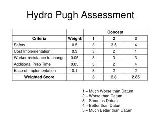
Augmenting Hydro-MET Data Demands of Impact Assessment Models. Team: IWMI (Charlotte, Solomon) Cornell (Tamo, Dan, Zach) BDU (Seifu, Esayas). Background. Modeling landscape processes requires detailed climatic and geographic datasets

E N D
Augmenting Hydro-MET Data Demands of Impact Assessment Models Team: IWMI (Charlotte, Solomon) Cornell (Tamo, Dan, Zach) BDU (Seifu, Esayas)
Background • Modeling landscape processes requires detailed climatic and geographic datasets • Meteorological stations in most parts of Africa are very sparse and most watersheds are un-gauged • Climate records are incomplete; high percentage of missing data and relevant variables • Poor data accessibility due to lack of data sharing agreement among trans-boundary riparian countries High-resolution global reanalysis data for SWAT modeling applications in Africa
Climate Forecast and Reanalysis System (CFSR) • A coupled atmosphere-ocean-land-sea ice system • Assimilates satellite radiances instead of the retrieved temperature and humidity values • Accounts for changing CO2 and other trace gases, and solar variations • Finer spatial (~38km) and temporal (hourly and daily) resolution • Assimilates hydrological quantities from a parallel LSM forced by CMAP and CPC unified daily gauge analysis
Applications of CFSR Data • Weather generator files for areas with missing and incomplete climate datasets • Solar radiation, relative humidity, wind speed • Maximum half-hour rainfall • SWAT weather input files for un-gauged watersheds • Climate downscaling and bias correction • Study of large-scale water and energy fluxes
Maximum Half-hour Rainfall • Strict sense simple scaling property: the probability distribution of maximum rainfall depth is invariant of time scale (Burlando and Rosso, 1996) • Wide sense simple scaling property: extends the scale-invariant property to quantiles and moments • If the reference duration is 1hr, then l = D
CFSR for Water Fluxes Study(percentage of water fluxes relative to rainfall in wet season)
Conclusions • High resolution reanalysis data had great potential to improve modeling of landscape processes • CFSR data has comparable performance as gauged climate data for SWAT modeling in Ethiopian highlands • The spatial pattern of CFSR data is useful for spatial downscaling and bias correction of GCM data • The water fluxes of the CFSR data could be to study large-scale fluxes without doing cumbersome data assimilation
CFSR Data Description CFSR_Grids_Data CFSR_SWAT_Inputs Grids’ Center Location Files: *.DBF’ and *.txt SWAT Input File Names: <cc>1<xx>2<yy>.txt <cc>: climate variables code (PC, TM, HM, SL and WN respectively for rainfall, temperature, relative humidity, solar radiation and wind speed) • Grids’ Center Location File: CFSR_Eth_Grids.xls • CFSR Data File Names: GP1<xx>2<yy>_Eth.csv <xx>: the grid number in west- east direction <yy>: the grid number in north- south direction CFSR_WGEN: monthly statistics and grids’ center location