Download
1 / 20
200 likes | 262 Views
Explore the predicted home computer in 2004. Learn about coordinated geospatial data programs, USGS strategic alignment, and the National Map vision. Discover the framework for surface water data integration and partnerships.

E N D
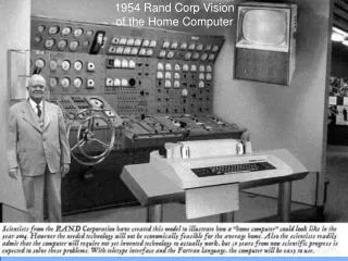
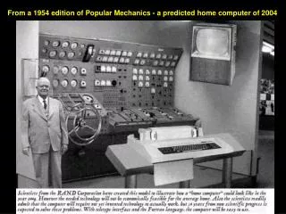
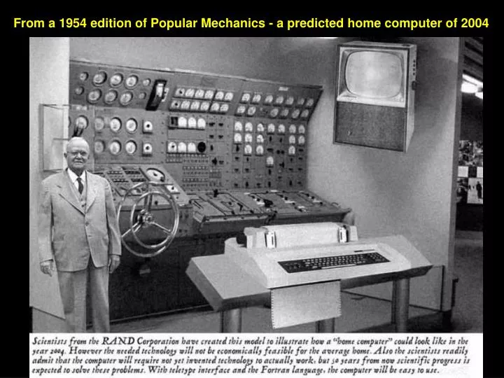
From a 1954 edition of Popular Mechanics - a predicted home computer of 2004
Connecting the Components • Integrated base data – The National Map • Coordination, standards, policy – Federal Geographic Data Committee • Discovery and access – Geospatial One-Stop • Optimize use of geospatial technologies– Enterprise Geospatial Information Management Coordination& Standards Consistent & Current Content Data Discovery & Access How are they different?
A Bold Step . . . Strategic Alignment of USGS Programs • Charge from USGS Director, August 2004 • Strategic Alignment of Activities • National leadership of highly visible, high-demand geospatial programs • Time to bring it all together!
NGPO Directions • Unify and simplify • Act as one, under one executive (Karen Siderelis, GIO) • Contribute to completion of the NSDI • Include partners in all aspects • Be unconstrained by today or yesterday – “how we look today is not how we will look tomorrow” • Bias toward action “transformation”
NGPO Core Team • Govern the process • Sponsor Study Teams • Prepare Final Plan and Report for USGS Director • “Pillars” • Ivan DeLoatch, Federal Geographic Data Committee • Mark DeMulder, Geospatial One Stop • Hank Garie, Cooperative Topographic Mapping Program • Bob Pierce, Interior Enterprise Geographic Information Management • Stan Ponce, Partnerships and External Coordination • Mark Naftzger, Emergency Operations
NGPO Study Teams • Unified Geospatial Enterprise Architecture • Geospatial Technology Integration • Partnership Offices • Unified NSDI Web Presence • Measuring Geospatial Investments • USGS Geospatial Products and Services
NGPO Purpose “Providing leadership to place reliable geographic information at the fingertips of the Nation.” http://www.usgs.gov/ngpo
Geo-spatial Framework for Surface Water Vision NHD Follow a drop of water from where it falls on the land, to the stream, and all the way to the ocean. NED EDNA How will this vision be attained? WBD
Geo-spatial Framework for Surface Water Sponsor: Subcommittee for Spatial Water Data • Federal Geographic Data Committee (FGDC) • Advisory Committee for Water Information (ACWI), Subcommittee for Spatial Water Data Information (SSWD)
The NationalWatershed Boundary Dataset (WBD) Kenny Legleiter, Michael Laitta & Karen Hanson WBD Technical Team
Geo-spatial Framework for Surface Water Watershed Boundary Dataset • Non-politically biased • Hydrologically sound • consisting of Common reporting units • Detailed Provide national standard framework of hydrologic units that are: National addressing system
Geo-spatial Framework for Surface Water Partners NWS (EDNA stage 1) NRCS (review, website, Hydro tools) Tools Standards Coordination Pilots USFS ($6M hi-res NHD, WBD) Subcommittee on spatial water data USEPA (NHD,EDNA tools, Flow & velocity work) NOAA (coastal watersheds) Data Stewardship State Partners (hi-res NHD, EDNA stage 2) USGS (Streamstats)
Subcommittee for Spatial Water Data Proposed WBD Work Groups/Teams: • Technical team • Management team • Program plan • Set priorities • $$ NEW!
New York NRCS IRT NRCS NYESF New York Watershed Boundary Commitments Challenge NYDEC NRCS/Titan EPA R3 NRCS NYESF Challenge