Download

1 / 43
450 likes | 552 Views
Learn about severe convective weather phenomena like multicell and supercell thunderstorms, cumulonimbus cloud types, and mesoscale convective systems in this informative lecture sequence. Explore how dynamic forcing, shear, and vorticity play roles in storm formation and development. Discover key factors contributing to tornado formation and the characteristics of mesocyclones. Gain insights into convective cloud distribution and precipitation patterns in severe weather events.

E N D
Severe Convection and Mesoscale Convective Systems R. A. Houze Lecture, Summer School on Severe and Convective Weather, Nanjing, 11 July 2011
Convective Clouds Lecture Sequence • Basic convective cloud types • Severe convection & mesoscale systems • Tropical cloud population • Convective feedbacks to large-scales • Extreme convection • Diurnal variability • Clouds in tropical cyclones
Two Types of Cumulonimbus “Multicell Thunderstorm” “Supercell Thunderstorm”
Why are there two types of cumulonimbus? What determinesp’?
In single-cell and multi-cell thunderstorms negligible
Strong rotation in cloud produces cyclostrophic pressure minima in the cloud dynamic forcing becomes important! This changes the storm from multicell to supercell
Tilting of the environment shear & “storm splitting” Assume unidirectional shear tilting of environment vorticity vortex min p’ min p’ PG force Storm “splits” as a result of this rotation-determined vertical force End up with two storms! Klemp 1987
Nonlinear processes required to form the mesocyclone Based on Rotunno1981
Why don’t we get two storms? Directional shear
The effect of directional shear can be seen by linearizing About a mean velocity of Which leads to Where S is the environment shear
Middle level of storm This implies lifting at low levels on downshear side of storm. S
Left mover When the hodograph is “unidirectional” Unidirectional shear In addition to pressure forces that cause storm splitting, vertical pressure gradient forces updraft on downshear side of storm, so storm BOTH splits AND moves forward. PG force Right mover Klemp 1987
Left mover When the hodograph is “clockwise” Vertical pressure gradient forces updraft on the right flank; downdraft on left flank. Clockwise hodograph V P G Right-mover favored Klemp 1987
T Tornado environment sounding CU PU “cap” CU Probable Location of Tornadic Thunderstorms Tornado (T) forms where wind pattern creates strong combination of CU and PU
T Probable Location of Tornadic Thunderstorms Tornado environment hodograph Note some shear is in the boundary layer Tornado (T) forms where the shear is both strong & directional
Further considerations for tornadic storms: • Shear in boundary layer (“helicity”) • Generation of vorticity by the storm
Factors contributing to tornado formation MESOCYCLONE HELICITY HORIZONTAL VORTICITY GENERATION
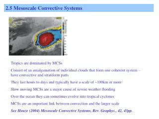
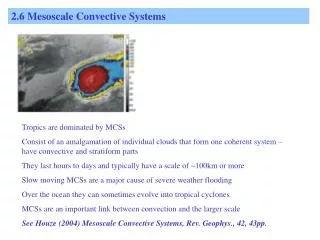
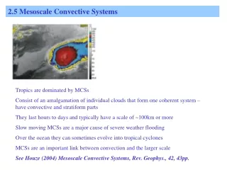
Mesoscale Convective System ~500 km
Three MCSs Mesoscale Convective System
Radar Echoes in the 3 MCSs 1458GMT 13 May 2004 StratiformPrecipitation ConvectivePrecipitation
When convection organizes into a mesoscale convective system • parcel theory doesn’t apply • layer lifting occurs
Parcel Model of Convection Parcels of air arise from boundary layer This doesn’t apply to mature MCS
Gravity Wave Interpretation Mean heating in convective line Horizontal wind Mesoscale response to the heating in the line 0 Pandya & Durran 1996
Vorticity interpretation When an MCS forms in a sheared environment, solutions to 2D vorticity equation look like this: B>0 Shear Moncrieff 1992
Vorticity interpretation Model results are consistent with the theory B>0 Get updraft in the form of a deep layer of ascending front-to-rear flow Horizontal vorticity generated by the line of convection Fovell & Ogura 1988
Oldconvection Vigorousconvection 100 km Subdivision of precipitation of MCSinto convective and stratiform components Houze 1997
Height Distance Vigorous Convection Max w > (VT)snow Big particles fall out near updraft Get vertical cores of max reflectivity Houze 1997
Height Distance Old Convection (VT)snow~1-2 m/s Ice particles drift downward Melting produces “bright band” Houze 1997
How convective cells distribute precipitation particles in the MCS Height “Particle fountains” Yuter & Houze 1995
Generalized structure of an MCS in shear • This type of MCS propagates with a • leading line of convection, aided by downdraft cold pool, and • trailing stratiform precipitation Storm motion Sheared flow leads to older convective elements being advected rearward SF precipitation area is to the rear. Houze et al. 1989
Heating & Cooling Processes in an MCS SW Cloud CpndensationandDeposition LW This vertical distribution of diabatic processes applies whether the MCS is propagating or not Melting Evaporation LW 125 km 30 km Stratiform precipitation Convective precipitation Houze 1982
Simplified MCS Heating Profiles Stratiform Height (km) Convective Schumacher et al. 2004 Deg K/day
Conclusion of Lectures 1 & 2: We have looked at all but the TCs Cumulonimbus Cumulus MesoscaleConvectiveSystem Stratocumulus Later Stratus Tropical Cyclone ✔
Summary of key points • Stratocumulus • Turbulence • Entrainment • Radiation • Drizzle • Cumulus & Cumulonimbus • Buoyancy • Entrainment • Anvil cloud & thunderstorms • Intensity over land & ocean • Pressure perturbations • Vorticity • Intense Cumulonimbus • Rotation • Speed and directional shear • Mesoscale Convective Systems • Layer lifting • Convective vs stratiform precipitation • Heating profiles
Convective Clouds Lecture Sequence • Basic convective cloud types • Severe convection & mesoscale systems • Tropical cloud population • Convective feedbacks to large-scales • Extreme convection • Diurnal variability • Clouds in tropical cyclones Next
This research was supported by NASA grants NNX07AD59G, NNX07AQ89G, NNX09AM73G, NNX10AH70G, NNX10AM28G, NSF grants, ATM-0743180, ATM-0820586, DOE grant DE-SC0001164 / ER-6
Precipitation-sized Ice Particles in MCSs over the Bay of Bengal in MONEX -25 Columns Plates & Dendrites Aggregates &Drops Columns -20 Dendrites -15 Flight Level Temperature (deg C) -10 * * Needles -5 0 Melting Relative Frequency of Occurrence Houze & Churchill 1987
Development of stratiform precipitation in a mesoscale convective system
Hail Rain Supercell Storm