Download
1 / 31
330 likes | 500 Views
Explore factors that control climate, including daily and yearly cycles, such as El Nino and Continental Glaciation. Learn about temperature and precipitation influences like latitude, altitude, and prevailing air masses. Discover global precipitation regions and their characteristics for a better understanding of climate systems.

E N D
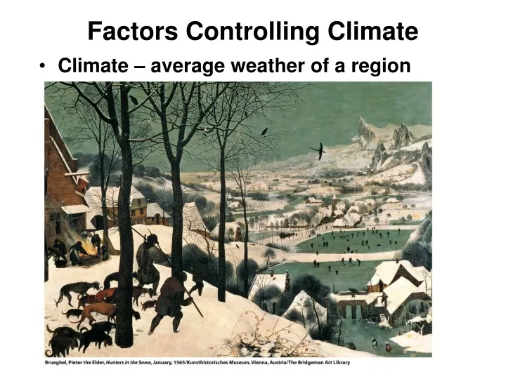
Factors Controlling Climate • Climate – average weather of a region
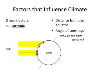
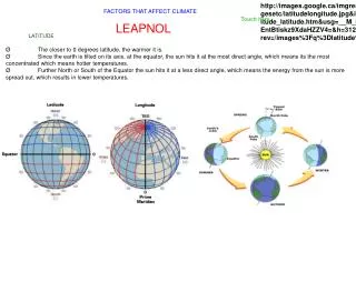
Factors Controlling Climate • Daily & annual cycles • Daily rotation of the Earth (day/night) • Annual revolution around the sun (seasons) • Longer-term cycles: • El Nino – several years • Continental Glaciation – hundreds of thousands of years • Factors influencing annual cycle of air temp:
Factors Controlling Climate • Factors influencing annual cycle of air temperature: • Latitude • Altitude • Coastal vs. Continental location • Factors influencing precipitation: • The three above, plus: • Annual & daily air temperaturess • Prevailing air masses • Relation to mountain barriers • Position of persistent low & high pressure center • Prevailing winds & ocean currents
Temperature Regimes • Temp Regime – Annual cycle of temp driven by latitude & location • Insolation is main control on temperature • Variation in insolation due to latitude • Effect of marine or continental location moderates variation
Precipitation Regimes • Seven global precipitation regions: • 1. Wet Equatorial Belt - >2000 mm (80 in) rainfall • mE air masses – heavy convective rainfall • 2. Trade-wind Coasts – 1500-2000 mm precip • Narrow belts from Equator to 30° N & S on east coast of continents • mT air masses carried on trade winds bring rainfall • 3. Tropical Deserts - < 250 mm rainfall • Located on or near tropics • cT air masses under subtropical highs
Precipitation Regimes • 4. Midlatitude deserts & steppes – 100-500 mm precip • In centers of continents, 30-50°N • In rainshadow of mountain chains to west • 5. Moist Subtropical – 1000-1500 mm precip • 25-40° N & S on moist, western side of subtropical high • mT air masses from ocean provide moisture for precip
6. Midlatitude West Coast – 1500-2000+mm precip • On west coasts of continents in path of moist westerlies • mP air masses & orographic precipitation • 7. Arctic & Polar Deserts - <300 mm precip • Above 60°N & S • cP & cA air masses can hold little moisture
Precipitation Regions Isohyets – lines drawn through areas with equal annual precipitation
Seasonality of Precipitation • Timing of precipitation during year key to climate • 3 types of precipitation patterns: • Uniform throughout year • Precipitation maximum during summer • Precipitation maximum during winter
Climate Classification • Based on mean monthly values of temp & precip • 13 climate types based on: • Air mass movements • Frontal zones • Climate types broken into 3 groups: • Group I – low latitudes - cT, mE and mT air masses • Group II – midlatitudes - Polar front, varied air masses • Group III – high latitudes - cP, mP and cA air masses
Climograph • Tool for defining the climate of a given location or region • Mean monthly temp on line chart • Mean monthly precip on bar chart • May include dominant weather systems
Low-Latitude Climates (Group I) • Wet Equatorial (1) – warm to hot w/abundant rainfall • Example – Amazon Basin or Congo • Trade Wind Coastal (2) – warm to hot w/very rainy season • Example – any coastal region exposed to trade winds
Low-Latitude Climates (Group I) • Wet-Dry Tropical (3) – warm to hot w/distinct wet & dry seasons • Example – Sahel or monsoon region of central India • Dry Tropical (4) – very hot in high-sun season, cooler in low sun • Little to no rainfall • Examples – Sahara Desert, Central Australia
Midlatitude Climates (Group II) • Dry Subtropical (5) – not as hot as dry tropical • Example – Death Valley, CA • Moist Subtropical (6) – hot, humid summers, mild winters, ample rain • Example – Southeastern US • Mediterranean (7) – hot, dry summers, rainy winters • Examples – Southern California, Mediterranean Sea
Midlatitude Climates (Group II) • Marine West Coast (8) – warm summers, cool, wet winters • Expls – Northwestern US • Dry Midlatitude (9) – warm to hot in summer, cold winter, little precip • Expl – Great Plains of North America • Moist Continental (10) – warm summer, cold winter, ample precip. • Expl – Northeastern US
High-Latitude Climates (Group III) • Boreal Forest (11) – short, cool summers, long, very cold winters • Example – Siberia, Central Alaska • Tundra (12) – short, cool summers, winters slightly warmer than (11) • Example – western Alaska coast • Ice Sheet (13) – bitter cold all year • Examples – inland Greenland and Antarctica