Download
1 / 62
650 likes | 1.04k Views
Unit 1: Geography GeoTrekkers in the Western Hemisphere Illustrated Glossary. adapt. to change in order to fit new conditions. archipelago. a group or chain of islands clustered together in a sea or ocean. bodies of water.

E N D
Unit 1: GeographyGeoTrekkers in the Western HemisphereIllustrated Glossary
adapt to change in order to fit new conditions
archipelago a group or chain of islands clustered together in a sea or ocean
bodies of water Water in different sizes and shapes naturally found on the Earth’s surface. Oceans, seas, bays, lakes, rivers, and ponds are examples of bodies of water.
bay an inlet of a body of water (as the sea) that is usually smaller than a gulf
Central America Southern part of North America extending from southern border of Mexico to northwestern Columbia.
climate local weather conditions of an area like temperature, precipitation, humidity, sunshine, wind and other conditions
coast the land next to the ocean
Compass Rose a symbol that shows the directions: north, south, east, and west
communication ways people send and receive messages thereby linking people and places
continent a very large body of land
degrees the unit of measurement used for latitude and longitude
delta a low, watery land formed at the mouth of a river. It is formed from the silt, sand and small rocks that flow downstream in the river and are deposited in the delta. A delta is often (but not always) shaped like a triangle (hence its name, delta, a Greek letter that is shaped like a triangle).
desert an area with less than ten inches of rain per year and a rocky sandy surface
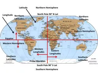
eastern hemisphere the half of Earth east of the Prime Meridian
environment the geographic characteristics that surround and affect the way people live
environment concerns/issues interests people have about the care of the natural environment.
forest an area where coniferous and deciduous trees are the most dominant plant. Deciduous trees share their leaves in the fall. Coniferous trees include trees that have pinecones, such as fir and spruce.
geography study of Earth and how people live on Earth and use its resources
geographic characteristics human physical things that distinguish one place from another. These are divided into two groups: physical and human
geography:physicalcharacteristics description of the natural environment of the place They include physical features (landforms and bodies of water), weather and climate, soil, vegetation, and animal life.
geography:human characteristics description of the people of a place past or present, their human-made features (buildings etc.), languages, religions, economic activities, and political systems
grasslands flat or rolling areas of land covered with grasses If located in North America, they are called prairies. In South America they are called pampas.
gulf a large body of water that cuts deep into the land
hemisphere half of the globe of half of the earth The four hemispheres are northern, southern, eastern, and western.
human/environmental interaction explains how people live in their environment
isthmus a narrow strip of land connecting two larger landmasses. An isthmus has water on two sides.
island a piece of land that has water all around it
landforms the different shapes of Earth’s surface Mountains, hills, plateaus, plains, valleys, peninsulas, and islands are examples of landforms
Latin America the entire Western Hemisphere south of the United States
lake a body of salt or fresh water that is surrounded by land
latitude/longitude imaginary lines on a map or globe that measure distance north and south of the equator and distance east and west of the prime meridian
legend/key explains the meaning of the symbols on the map
marsh an area of soft wet land usually overgrown by grasses
migrate/migration/immigration to move from one country or region to another with the intent of staying at the place for a long period of time
modify to change to meet the wants of people
mountains a land form that is very high and steep. They usually are wide at the bottom and rise to a narrow peak or ridge. Geographers classify a mountain as land that rises at least 2000 feet above sea level. A number of mountains next to each other make up a mountain range
natural environment the physical setting of a place including the land, air ,water, plants, and animals
North America continent comprising Greenland, United States, Mexico, Central America
northern hemisphere the half of the earth north of the equator
ocean a large body of saltwater
physical map a map that shows landforms This is a physical map of the United States.
plains large areas of flat lands
plateau high, flat land
political map a map that shows location and borders of countries and communities
Prime Meridian the line of longitude from the South Pole to the North Pole measured in degrees. It divides Earth into Eastern and Western Hemispheres.
province an administrative district or division of a country
rainforest a dense, either tropical or temperate forest that receives lots of rain year round
resources things that people can use, such as oil, lumber, and water that come from nature
river flow of water that goes to an ocean or lake