Download
1 / 19
190 likes | 763 Views
Outline. Definitions: Tectonics, Caribbean PlatePlate TectonicsEvolution of the CaribbeanPhysiographic/Tectonic ProvincesTectonics of the CaribbeanSummary. Tectonics. The processes responsible for tectonic activityField of study concerned with structures within the crust and with forces and movements that operate to create theseConcerned with mountain building

E N D
1. Tectonics of the Caribbean Richard Robertson
Seismic Research Unit, U.W.I.
St. Augustine, Trinidad
www.uwiseismic.com
2. Outline Definitions: Tectonics, Caribbean Plate
Plate Tectonics
Evolution of the Caribbean
Physiographic/Tectonic Provinces
Tectonics of the Caribbean
Summary Definition of �tectonics� and �Caribbean Plate�
Plate tectonic principles
Evolution of the major physiographic and tectonic features in the Caribbean
Description of the Physiographic and Tectonic Features and their implications for and illustration of seismicity, volcanism and potential tsunamigenic zones
NOTE: Geomorphic, or physiographic, regions are broad-scale subdivisions based on terrain texture, rock type, and geologic structure and history (source: http://tapestry.usgs.gov/physiogr/physio.html)Definition of �tectonics� and �Caribbean Plate�
Plate tectonic principles
Evolution of the major physiographic and tectonic features in the Caribbean
Description of the Physiographic and Tectonic Features and their implications for and illustration of seismicity, volcanism and potential tsunamigenic zones
NOTE: Geomorphic, or physiographic, regions are broad-scale subdivisions based on terrain texture, rock type, and geologic structure and history (source: http://tapestry.usgs.gov/physiogr/physio.html)
3. Tectonics The processes responsible for tectonic activity
Field of study concerned with structures within the crust and with forces and movements that operate to create these
Concerned with mountain building & with the development of cratons and tectonic terranes => earthquakes, volcanoes & tsunamis �Tectonics� => Greek => builder
Tectonic:
a) descriptive of a structure produced by deformation;
b) relating to a major Earth structure and its formation
Concerned with orogenies & with the development of cratons and tectonic terranes; also with earthquake and volcanic belts
Important for understanding processes of erosion, patterns in geomorphology
Useful in economic geology particularly in search for petroleum and metallic ores�Tectonics� => Greek => builder
Tectonic:
a) descriptive of a structure produced by deformation;
b) relating to a major Earth structure and its formation
Concerned with orogenies & with the development of cratons and tectonic terranes; also with earthquake and volcanic belts
Important for understanding processes of erosion, patterns in geomorphology
Useful in economic geology particularly in search for petroleum and metallic ores
4. The Earth�s layered structure Inner core: 1216 km thick and consists of solid rock at very high temperature and pressure
Outer core: extends up to 2270 km from the centre of the earth and consists mainly of molten iron with about 10% nickel and traces of other materials
Mantle: extends to ~ 2900 km and consists of silicate rocks; due to high temperature and pressure the rocks are able to flow extremely slowly like a thick & stick liquid
The Mantle accounts for 83 % of the Earth�s volume & 67% of its mass
The Upper and lower mantle separated by the 670 km seismic discontinuity (Source http://en.wikipedia.org/wiki/Earth#Composition_and_structure)
The interior of the Earth is chemically divided into layers
The Earth has an outer silicate solid crust, a highly viscous mantle, a liquid outer core that is much less viscous than the mantle, and a solid [[inner core]]. The crust is separated from the mantle by the Mohorovicic discontinuity, and the thickness of the crust varies: averaging 6�km under the oceans and 30�50�km on the continents.[24]
According to plate tectonics theory, the outermost part of the Earth's interior is made up of two layers: the lithosphere, comprising the crust, and the solidified uppermost part of the mantle. Below the lithosphere lies the asthenosphere, which forms the inner part of the mantle. The asthenosphere behaves like a superheated and extremely viscous liquid.[30]
The lithosphere essentially floats on the asthenosphere and is broken up into what are called tectonic plates. These plates are rigid segments that move in relation to one another at one of three types of plate boundaries: convergent, divergent and transform. The last occurs where two plates move laterally relative to each other, creating a strike-slip fault. Earthquakes, volcanic activity, mountain-building, and oceanic trench formation can occur along these plate boundaries.[31](Source http://en.wikipedia.org/wiki/Earth#Composition_and_structure)
The interior of the Earth is chemically divided into layers
The Earth has an outer silicate solid crust, a highly viscous mantle, a liquid outer core that is much less viscous than the mantle, and a solid [[inner core]]. The crust is separated from the mantle by the Mohorovicic discontinuity, and the thickness of the crust varies: averaging 6�km under the oceans and 30�50�km on the continents.[24]
According to plate tectonics theory, the outermost part of the Earth's interior is made up of two layers: the lithosphere, comprising the crust, and the solidified uppermost part of the mantle. Below the lithosphere lies the asthenosphere, which forms the inner part of the mantle. The asthenosphere behaves like a superheated and extremely viscous liquid.[30]
The lithosphere essentially floats on the asthenosphere and is broken up into what are called tectonic plates. These plates are rigid segments that move in relation to one another at one of three types of plate boundaries: convergent, divergent and transform. The last occurs where two plates move laterally relative to each other, creating a strike-slip fault. Earthquakes, volcanic activity, mountain-building, and oceanic trench formation can occur along these plate boundaries.[31]
5. Lithospheric Plates The main plates are:
African Plate (61.3 x10⁶ km2) => Africa
Antarctic Plate (60.9 x10⁶ km2) => Antarctica
Australian Plate 47.2 x10⁶ km2) => Australia
Eurasian Plate (67.8 x10⁶ km2) => Asia and Europe
North American Plate (75.9 x10⁶ km2) => North America and north-east Siberia
South American Plate (43.6 x10⁶ km2) => South America
Pacific Plate (103.3 x10⁶ km2) => Pacific Ocean
Notable minor plates:
the Indian Plate, the Arabian Plate, the Caribbean Plate, the Nazca Plate off the west coast of South America
the Scotia Plate in the southern Atlantic Ocean
The Australian Plate fused with Indian Plate between 50 and 55 million years ago.
The fastest-moving plates are the oceanic plates, with the Cocos Plate advancing at a rate of 75�mm/yr (3.0�in/yr) and the Pacific Plate moving 52-69�mm/yr (2.1�2.7 in/yr).
At the other extreme, the slowest-moving plate is the Eurasian Plate, progressing at a typical rate of about 21�mm/yr (0.8�in/yr)The main plates are:
African Plate (61.3 x10⁶ km2) => Africa
Antarctic Plate (60.9 x10⁶ km2) => Antarctica
Australian Plate 47.2 x10⁶ km2) => Australia
Eurasian Plate (67.8 x10⁶ km2) => Asia and Europe
North American Plate (75.9 x10⁶ km2) => North America and north-east Siberia
South American Plate (43.6 x10⁶ km2) => South America
Pacific Plate (103.3 x10⁶ km2) => Pacific Ocean
Notable minor plates:
the Indian Plate, the Arabian Plate, the Caribbean Plate, the Nazca Plate off the west coast of South America
the Scotia Plate in the southern Atlantic Ocean
The Australian Plate fused with Indian Plate between 50 and 55 million years ago.
The fastest-moving plates are the oceanic plates, with the Cocos Plate advancing at a rate of 75�mm/yr (3.0�in/yr) and the Pacific Plate moving 52-69�mm/yr (2.1�2.7 in/yr).
At the other extreme, the slowest-moving plate is the Eurasian Plate, progressing at a typical rate of about 21�mm/yr (0.8�in/yr)
6. Plate boundary settings Types of plate margins/plate boundaries exist, characterized by the way the plates move relative to each other. They are associated with different types of surface phenomena. The different types of plate boundaries are:
Spreading centres or divergent plate boundaries: occur where two plates slide apart from each other. Mid-ocean ridges (e.g., Mid-Atlantic Ridge) and active zones of rifting (such as Africa's Great Rift Valley) are both examples of divergent boundaries
Subduction zones or convergent plate boundaries: occur where two plates slide towards each other commonly forming either a subduction zone (if one plate moves underneath the other) or a continental collision (if the two plates contain continental crust). Deep marine trenches are typically associated with subduction zones. Because of friction and heating of the subducting slab, volcanism is almost always closely linked. Examples of this are the Andes mountain range in South America and the Japanese island arc.
Earthquakes also occur at transform plate boundaries: occur where plates slide or, perhaps more accurately, grind past each other along transform faults. The relative motion of the two plates is either sinistral (left side toward the observer) or dextral (right side toward the observer). The San Andreas Fault in California is one example
Types of plate margins/plate boundaries exist, characterized by the way the plates move relative to each other. They are associated with different types of surface phenomena. The different types of plate boundaries are:
Spreading centres or divergent plate boundaries: occur where two plates slide apart from each other. Mid-ocean ridges (e.g., Mid-Atlantic Ridge) and active zones of rifting (such as Africa's Great Rift Valley) are both examples of divergent boundaries
Subduction zones or convergent plate boundaries: occur where two plates slide towards each other commonly forming either a subduction zone (if one plate moves underneath the other) or a continental collision (if the two plates contain continental crust). Deep marine trenches are typically associated with subduction zones. Because of friction and heating of the subducting slab, volcanism is almost always closely linked. Examples of this are the Andes mountain range in South America and the Japanese island arc.
Earthquakes also occur at transform plate boundaries: occur where plates slide or, perhaps more accurately, grind past each other along transform faults. The relative motion of the two plates is either sinistral (left side toward the observer) or dextral (right side toward the observer). The San Andreas Fault in California is one example
7. The Caribbean Plate A lithospheric plate consisting mainly of a unusually thick, oceanic plateau situated between two major continental regions
A geologically complex region that displays a variety of plate boundary interactions including subduction (Lesser Antilles), transcurrent/strike-slip (north & south) and sea-floor spreading (Cayman Trough) Boundaries of Caribbean Plate: ~ from Guatemala along trend of the Cayman Trough, through Hispaniola and Puerto Rico, south through the Lesser Antilles and along the northern South American continental margin (boundary is poorly defined between Trinidad and Andes) and the west coast of Central America
Defined by the distribution of earthquake epicentres
Difficult to pinpoint precise plate boundary between north & south Caribbean Plate boundaries => described as plate boundary zones
The Caribbean hosts six major tectonic plates, with divergent, convergent and transform plate boundaries all present. Seismicity in the region is concentrated in all of these settings. About 1% of the world's seismic energy is released in the Caribbean
NB:
(Source http://www.uwsp.edu/geo/faculty/ritter/glossary/l_n/lithospheric_plates.html): Lithospheric plates are the plates that comprise the fractured surface of the earth. Lithospheric plates are of two types: continental plates comprised mostly of granitic-type rock rich in silica and aluminum (also called "sial") and oceanic plates comprised mostly of basaltic-type rocks rich in magnesium and aluminum (also called "sima"). Earthquake and volcanic activity is common along the boundaries of lithospheric plates
(Source http://en.wikipedia.org/wiki/Lithosphere): The lithosphere (IPA: lith'usfer, from the Greek for "rocky" sphere) is the solid outermost shell of a rocky planet. On the Earth, the lithosphere includes the crust and the uppermost mantle which is joined to the crust across the Mohorovicic discontinuity. Lithosphere is underlain by asthenosphere, the weaker, hotter, and deeper part of the upper mantle. The base of the lithosphere-asthenosphere boundary corresponds approximately to the depth of the melting temperature in the mantle. As the conductively cooling surface layer of the Earth's convection system, the lithosphere thickens over time. It is fragmented into tectonic plates (shown in the picture), which move independently relative to one another. This movement of lithospheric plates is described as plate tectonics.
The concept of the lithosphere as Earth�s strong outer layer was developed by Barrell, who wrote a series of papers introducing the concept (Barrell 1914a-c). The concept was based on the presence of significant gravity anomalies over continental crust, from which he inferred that there must exist a strong upper layer (which he called the lithosphere) above a weaker layer which could flow (which he called the asthenosphere). These ideas were enlarged by Daly (1940), and have been broadly accepted by geologists and geophysicists. Although these ideas about lithosphere and asthenosphere were developed long before plate tectonic theory was articulated in the 1960's, the concepts that strong lithosphere exists and that this rests on weak asthenosphere are essential to that theory.
The division of Earth's outer layers into lithosphere and asthenosphere should not be confused with the chemical subdivision of the outer Earth into mantle, and crust. All crust is in the lithosphere, but lithosphere generally contains more mantle than crust.
There are two types of lithosphere:
Oceanic lithosphere, which is associated with Oceanic crust
Continental lithosphere, which is associated with Continental crust
Boundaries of Caribbean Plate: ~ from Guatemala along trend of the Cayman Trough, through Hispaniola and Puerto Rico, south through the Lesser Antilles and along the northern South American continental margin (boundary is poorly defined between Trinidad and Andes) and the west coast of Central America
Defined by the distribution of earthquake epicentres
Difficult to pinpoint precise plate boundary between north & south Caribbean Plate boundaries => described as plate boundary zones
The Caribbean hosts six major tectonic plates, with divergent, convergent and transform plate boundaries all present. Seismicity in the region is concentrated in all of these settings. About 1% of the world's seismic energy is released in the Caribbean
NB:
(Source http://www.uwsp.edu/geo/faculty/ritter/glossary/l_n/lithospheric_plates.html): Lithospheric plates are the plates that comprise the fractured surface of the earth. Lithospheric plates are of two types: continental plates comprised mostly of granitic-type rock rich in silica and aluminum (also called "sial") and oceanic plates comprised mostly of basaltic-type rocks rich in magnesium and aluminum (also called "sima"). Earthquake and volcanic activity is common along the boundaries of lithospheric plates
(Source http://en.wikipedia.org/wiki/Lithosphere): The lithosphere (IPA: lith'usfer, from the Greek for "rocky" sphere) is the solid outermost shell of a rocky planet. On the Earth, the lithosphere includes the crust and the uppermost mantle which is joined to the crust across the Mohorovicic discontinuity. Lithosphere is underlain by asthenosphere, the weaker, hotter, and deeper part of the upper mantle. The base of the lithosphere-asthenosphere boundary corresponds approximately to the depth of the melting temperature in the mantle. As the conductively cooling surface layer of the Earth's convection system, the lithosphere thickens over time. It is fragmented into tectonic plates (shown in the picture), which move independently relative to one another. This movement of lithospheric plates is described as plate tectonics.
The concept of the lithosphere as Earth�s strong outer layer was developed by Barrell, who wrote a series of papers introducing the concept (Barrell 1914a-c). The concept was based on the presence of significant gravity anomalies over continental crust, from which he inferred that there must exist a strong upper layer (which he called the lithosphere) above a weaker layer which could flow (which he called the asthenosphere). These ideas were enlarged by Daly (1940), and have been broadly accepted by geologists and geophysicists. Although these ideas about lithosphere and asthenosphere were developed long before plate tectonic theory was articulated in the 1960's, the concepts that strong lithosphere exists and that this rests on weak asthenosphere are essential to that theory.
The division of Earth's outer layers into lithosphere and asthenosphere should not be confused with the chemical subdivision of the outer Earth into mantle, and crust. All crust is in the lithosphere, but lithosphere generally contains more mantle than crust.
There are two types of lithosphere:
Oceanic lithosphere, which is associated with Oceanic crust
Continental lithosphere, which is associated with Continental crust
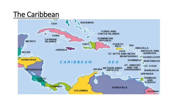
8. The Caribbean
9. Evolution of Caribbean Allochthonous/Mobilist vs. In Situ/Fixist models for origin of Caribbean
In-situ evolution
Gulf of Mexico & Caribbean region existed in the past i.e. during Triassic, Jurassic & early Cretaceous
Allocthonous evolution:
All accept significant amounts of eastward Caribbean migration relative to the Americas
A Great Arc vs Multi-arc evolution of the region
Interpretation of the facts => A single geology and too many points of view There is still not a consensus concerning the basic issue of the allochthonous- versus in situ- origin of the Caribbean Plate
The causes are probably two fold:
Insufficient geological knowledge of important segments of the region, and
Lack of interaction with all the available data, especially by some authors that simply choose to ignore important contributions to the geology and geophysics of the region.
Fixist views:
Giunta et al (1999), Meschede & Frisch (1998) & James (2003)
Gulf of Mexico & Caribbean region existed in the past i.e. during Triassic, Jurassic & early Cretaceous
Difficult to entertain given well-documented evidence of opening history of Atlantic Ocean and the Pangean continental assemblies => both should non-existence of Gulf of Mexico & Caribbean in the past
Is not clear the source of the crust required to feed the subduction zones and produce the volcanic activity of the arcs.
Can not explain the absent of volcanic contamination of the platforms (Yucatan, Florida, Bahamas) surrounding the Caribbean.
Mobilist views:
All accept significant amounts of eastward Caribbean migration relative to the Americas
Split in terms of models which generate lithosphere of Caribbean Plate between the Americas and models which generate Caribbean lithosphere in the Pacific Evolution of the Caribbean.
Definitive proof will only come when the deep interior (not just rims) of Caribbean Plate are shown to be pre-Aptian in origin => since plate reconstructions dictate that Caribbean Plate could not be fitted between America�s until well after Aptian
There is still not a consensus concerning the basic issue of the allochthonous- versus in situ- origin of the Caribbean Plate
The causes are probably two fold:
Insufficient geological knowledge of important segments of the region, and
Lack of interaction with all the available data, especially by some authors that simply choose to ignore important contributions to the geology and geophysics of the region.
Fixist views:
Giunta et al (1999), Meschede & Frisch (1998) & James (2003)
Gulf of Mexico & Caribbean region existed in the past i.e. during Triassic, Jurassic & early Cretaceous
Difficult to entertain given well-documented evidence of opening history of Atlantic Ocean and the Pangean continental assemblies => both should non-existence of Gulf of Mexico & Caribbean in the past
Is not clear the source of the crust required to feed the subduction zones and produce the volcanic activity of the arcs.
Can not explain the absent of volcanic contamination of the platforms (Yucatan, Florida, Bahamas) surrounding the Caribbean.
Mobilist views:
All accept significant amounts of eastward Caribbean migration relative to the Americas
Split in terms of models which generate lithosphere of Caribbean Plate between the Americas and models which generate Caribbean lithosphere in the Pacific Evolution of the Caribbean.
Definitive proof will only come when the deep interior (not just rims) of Caribbean Plate are shown to be pre-Aptian in origin => since plate reconstructions dictate that Caribbean Plate could not be fitted between America�s until well after Aptian
10. Evolution of the Caribbean Plate Allochthonous model � Multi-arc concept after Pindell 1994
Caribbean originated in 3 stages:
Proto-Caribbean Stage:
Triassic through Early Cretaceous
Concurrent with breakup and disruption of Pangea
Concurrent with evolution of an in situ oceanic crust in the Gulf of Mexico and the Caribbean
MesoCaribbean Stage:
Early Cretaceous
Coincidental with extensive development of volcanic island arcs in Eastcentral Pacific Ocean (these defined the eastern converging margins of the Caribbean Plate therefore => the Caribbean originated in the Pacific)
NeoCaribbean Stage:
started when CP began active eastward drift wrt the North & South American plates
ProtoCaribbean lithosphere largely subducted and overridden by allochthonous CPAllochthonous model � Multi-arc concept after Pindell 1994
Caribbean originated in 3 stages:
Proto-Caribbean Stage:
Triassic through Early Cretaceous
Concurrent with breakup and disruption of Pangea
Concurrent with evolution of an in situ oceanic crust in the Gulf of Mexico and the Caribbean
MesoCaribbean Stage:
Early Cretaceous
Coincidental with extensive development of volcanic island arcs in Eastcentral Pacific Ocean (these defined the eastern converging margins of the Caribbean Plate therefore => the Caribbean originated in the Pacific)
NeoCaribbean Stage:
started when CP began active eastward drift wrt the North & South American plates
ProtoCaribbean lithosphere largely subducted and overridden by allochthonous CP
11. The Caribbean IGCP Project 433 Is the Caribbean Plate allochthonous or developed in situ?
There is a single Great Arc or the compressive margins evolved as multiarcs?
Why can not be reconcile local geology with the general models?
The Caribbean IGCP Project 433 created a suitable scenario for extensive debate about the plate tectonic evolution of the area. Nevertheless they failed to reach an agreement in three basic points:
Is the Caribbean Plate allochthonous or developed in situ?
There is a single Great Arc or the compressive margins evolved as multiarcs?
Why can not be reconcile local geology with the general models?
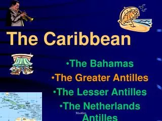
12. Physiographic regions The Caribbean:
Comprised of several major marine and terrestrial physiographic and geologic provinces
Geographic & bathymetric boundaries of the Caribbean Sea:
Gulf of Mexico, Yucatan Platform, Florida-Bahamas Platform & Puerto Rico Trench => north
South American continent => south
Central American, Isthmus of Panama => west
Lesser Antilles archipelago => east
Deeper water regions within Caribbean:
Yucatan Basic, Cayman Trough, Colombian Basic, Venezuelan Basin, Grenada Basic
Linear ridges separating these regions:
Cayman Ridge, Nicaraguan Rise, Beata Ridge, Aves Ridge
Physiographic regions correspond to the various crustal provinces that comprise the Caribbean and are a reflection of the active tectonic elements that make up the present Caribbean Plate
The Caribbean:
Comprised of several major marine and terrestrial physiographic and geologic provinces
Geographic & bathymetric boundaries of the Caribbean Sea:
Gulf of Mexico, Yucatan Platform, Florida-Bahamas Platform & Puerto Rico Trench => north
South American continent => south
Central American, Isthmus of Panama => west
Lesser Antilles archipelago => east
Deeper water regions within Caribbean:
Yucatan Basic, Cayman Trough, Colombian Basic, Venezuelan Basin, Grenada Basic
Linear ridges separating these regions:
Cayman Ridge, Nicaraguan Rise, Beata Ridge, Aves Ridge
Physiographic regions correspond to the various crustal provinces that comprise the Caribbean and are a reflection of the active tectonic elements that make up the present Caribbean Plate
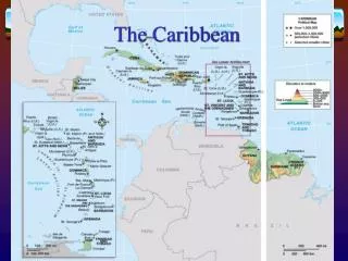
13. Geologic Provinces Geologic Provinces: (See Donovan & Jackson (1994): Caribbean Geology � An Introduction. UWIPA, Jamaica, ISBN 976-41-0033-3, for more details)
AP = Anegada Passage
AR = Aves Ridge
BeR = Beata Ridge
BP = Bahamas Platform
BR = Barbados Ridge & Lesser Antilles Deformed Belt
C = Cuba
CA = Colombian Andes
CB = Chortis Block
ChB = Choco Block
CO = Cuban Orogenic Belt
CoB = Colombian Basin
CT = Cayman Trough
CtB = Chorotega Block
EPFZ = El Pilar Fault Zone
GA = Greater Antilles
GAOB = Greater Antilles Orogenic Belt
GB Grenada Basin
GM = Gulf of Mexico
H = Hispaniola (Haiti + Dominican Republic)
J = Jamaica
LA + Lesser Antilles
MPFZ = Motangua-Polochic Fault Zone
NP = Nazca Plate
NPD = North Panama Deformed Belt
NR = Nicaraguan Rise
OTF = Oriente Transform Fault
PR = Puerto Rico
SCD = South Caribbean Deformed Belt
SITF = Swan Island Transform Fault
VB = Venezuelan Basin
VBo = Venezuelan Borderland
YB = Yucatan/Maya Block
YBa = Yucatan Basin
Geologic Provinces: (See Donovan & Jackson (1994): Caribbean Geology � An Introduction. UWIPA, Jamaica, ISBN 976-41-0033-3, for more details)
AP = Anegada Passage
AR = Aves Ridge
BeR = Beata Ridge
BP = Bahamas Platform
BR = Barbados Ridge & Lesser Antilles Deformed Belt
C = Cuba
CA = Colombian Andes
CB = Chortis Block
ChB = Choco Block
CO = Cuban Orogenic Belt
CoB = Colombian Basin
CT = Cayman Trough
CtB = Chorotega Block
EPFZ = El Pilar Fault Zone
GA = Greater Antilles
GAOB = Greater Antilles Orogenic Belt
GB Grenada Basin
GM = Gulf of Mexico
H = Hispaniola (Haiti + Dominican Republic)
J = Jamaica
LA + Lesser Antilles
MPFZ = Motangua-Polochic Fault Zone
NP = Nazca Plate
NPD = North Panama Deformed Belt
NR = Nicaraguan Rise
OTF = Oriente Transform Fault
PR = Puerto Rico
SCD = South Caribbean Deformed Belt
SITF = Swan Island Transform Fault
VB = Venezuelan Basin
VBo = Venezuelan Borderland
YB = Yucatan/Maya Block
YBa = Yucatan Basin
14. Tectonics of the Caribbean - I Result primarily from the interaction of one relatively small plate of lithosphere with surrounding plates
The Caribbean � geologically complex region; variety of plate boundary interactions including:
Subduction (Lesser Antilles & Central America)
Transcurrent (strike-slip) on northern and southern boundaries
Sea floor spreading in Cayman Trough The location and nature of plate boundaries are determined by:
The location of EQ hypocentres;
The use of the sense of slip from first motion studies on seismogenic faults
From detailed bathymetric, magnetic and seismic profiling studies of the marine area
From detailed mapping of recent, on-land structures if the plate boundary happens to be exposed onshore
First motion solutions indicate:
Left-lateral strike slip at northern boundary
Right-lateral strike slip at the southern boundary
Trust fault solutions at western and eastern margins of plate
Northern & southern boundaries of plate are transform fault systems dominated by left-lateral & right-lateral strike-slip motions
CP moves eastwards wrt N & SA plates at rate of ~1-2 cm y-1
Movements are distributed on several active fault zones => produce broad, active seismic zones ~200 km wide
Motagua, Polochi & other fault zones form eastern extension of Northern Caribbean Plate Boundary Zone in Central America
Left lateral step-over occurs in boundary between the Caribbean and North America => crustal-scale pull-apart basin � the Cayman Trough with 100 km long spreading ridge segment has been produced by a left lateral step-over in the boundary between the Caribbean and North America plate
Eastern movement of CP => subduction of Atlantic Ocean crust under eastern margin of CP => LA island arc
Eastward movement of Pacific & Cocos Plates wrt CP & NA => subduction beneath western margin of CP under Central AmericaThe location and nature of plate boundaries are determined by:
The location of EQ hypocentres;
The use of the sense of slip from first motion studies on seismogenic faults
From detailed bathymetric, magnetic and seismic profiling studies of the marine area
From detailed mapping of recent, on-land structures if the plate boundary happens to be exposed onshore
First motion solutions indicate:
Left-lateral strike slip at northern boundary
Right-lateral strike slip at the southern boundary
Trust fault solutions at western and eastern margins of plate
Northern & southern boundaries of plate are transform fault systems dominated by left-lateral & right-lateral strike-slip motions
CP moves eastwards wrt N & SA plates at rate of ~1-2 cm y-1
Movements are distributed on several active fault zones => produce broad, active seismic zones ~200 km wide
Motagua, Polochi & other fault zones form eastern extension of Northern Caribbean Plate Boundary Zone in Central America
Left lateral step-over occurs in boundary between the Caribbean and North America => crustal-scale pull-apart basin � the Cayman Trough with 100 km long spreading ridge segment has been produced by a left lateral step-over in the boundary between the Caribbean and North America plate
Eastern movement of CP => subduction of Atlantic Ocean crust under eastern margin of CP => LA island arc
Eastward movement of Pacific & Cocos Plates wrt CP & NA => subduction beneath western margin of CP under Central America
15. Tectonics of the Caribbean - II Caribbean � a lithospheric plate that consists mainly of anomalously thick, oceanic plateau located between 2 major continental regions => tectonic interactions between thick oceanic crust and continental crust
16. Caribbean Seismicity First motion studies indicate left-lateral strike slip at northern & right-lateral strike slip at southern boundary => left lateral and right lateral transform boundaries
Thrust fault solutions, typical of upper parts of convergent plate boundaries occur at western and eastern margins of plate
Depth of hypocentres and their positions relative to island arc volcanoes indicates Wadati-Benioff Zones dipping eastward beneath Central American & westward beneath Lesser Antilles
17. Summary The Caribbean is a geologically complex region which exhibits a variety of plate boundary interactions and by extension tectonic features
It is a lithospheric plate that consists mainly of anomalously thick, oceanic plateau located between 2 major continental regions
Despite recent advances in knowledge there is still disagreement over its evolution Failure to reach agreement in terms of evolution of the Caribbean Plate is a reflection of:
Insufficient knowledge of the local and regional geology
Differences in interpretation amongst geologists even when considering the same date!
The Caribbean is a single place of the earth, so it had had a single history
However there are many ways to look at the CaribbeanFailure to reach agreement in terms of evolution of the Caribbean Plate is a reflection of:
Insufficient knowledge of the local and regional geology
Differences in interpretation amongst geologists even when considering the same date!
The Caribbean is a single place of the earth, so it had had a single history
However there are many ways to look at the Caribbean
18. References Mattson, Peter, H. ed. (1977): West Indies island arcs. Benchmark Papers in Geology V. 33. Dowden, Hutchinson & Ross, Inc., p. 361. (see Chapters 2, 32-35b)
Jackson, Trevor, A. ed. (2002): Caribbean Geology into the Third Millennium � transactions of the Fifteenth Caribbean Geological Conference. University of the West Indies Press, 279p.
Donovan, Stephen K. and Jackson, Trevor, A. (1994): Caribbean Geology � An Introduction. The University of the West Indies Publishers Association, Jamaica, 289p.
http://www.ig.utexas.edu/CaribPlate/CaribPlate.html
19. Seismic Research Unit Earthquake & Volcano Monitoring
Research & Public Education
www.uwiseismic.com
20. Thank you for listening! Earthquake & Volcano Monitoring
Research & Public Education