Download
1 / 82
820 likes | 1.16k Views
Technical Workshop on Numerical Guidance to Support WoF 5 February 2013. Storm-Scale Modeling with HRRR toward Warn-On-Forecast. NOAA Earth System Research Laboratory GSD/AMB Stan Benjamin, Curtis Alexander, David Dowell, Steve Weygandt, Ming Hu, Tanya Smirnova , John Brown,

E N D
Technical Workshop on Numerical Guidance to Support WoF 5 February 2013 Storm-Scale Modeling with HRRR toward Warn-On-Forecast NOAAEarth System Research Laboratory GSD/AMB Stan Benjamin, Curtis Alexander, David Dowell, Steve Weygandt, Ming Hu,Tanya Smirnova, John Brown, Patrick Hofmann, Eric James, Ed Szoke, Haidao Lin
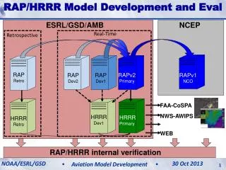
RUCtoRapid Refresh transition • North American domain • WRF-ARW Model • GSI – • Unipost • CONUS domain • RUC Model • RUC 3dvar • RUC post Gridpoint Statistical Interpolation Hourly updated models 13km RUC 13km Rapid Refresh 3km HRRR NCEP Production Suite Review Rapid Refresh / HRRR 4-5 December 2012
WRF-ARW / GSI enhancements for RAP • GSD contributions to WRF-ARW • Grell 3-D cumulus scheme (updated each version) • RUC (Smirnova) land-surface model (“ “ “) • Diabatic Digital Filter Initialization (with NCAR) • DFI-radar-latent heat reflectivity assimilation • Modified MYNN PBL (v3.5) • Latent heat limit to allow much longer time steps • GSD contributions to GSI • Non-variational cloud analysis • Ingest for cloud / hydrometeor fields / obs • Enhancements to surface obsassimilation / soil adjustment • Options – aircraft V/T/RH reject list, temp bias correction NCEP Production Suite Review Rapid Refresh / HRRR 4-5 December 2012
RUC RAP /HRRRconfiguration Community-based advanced model and analysis - WRF-ARW: advanced numerics, non-hydrostatic - GSI: advanced satellite data assimilation
Rapid RefreshHourly Update Cycle Partial cycle atmospheric fields – introduce GFS information 2x/day Cycle hydrometeors Fully cycle all land-sfcfields (soil temp, moisture, snow) 1-hr fcst 1-hr fcst 1-hr fcst Back- ground Fields Analysis Fields 3DVAR 3DVAR Obs Obs Time (UTC) 11 12 13
Radar reflectivity assimilation Digital filter-based reflectivity assimilation initializes ongoing precipitation regions -20 min -10 min Initial +10 min + 20 min Backwards integration, no physics Forward integration,full physics with radar-based latent heating Initial fields with improved balance, storm-scale circulation RUC / RAP HRRR model forecast + RUC/RAP Convection suppression NCEP Production Suite Review Rapid Refresh / HRRR 4-5 December 2012
Rapid Refresh (GSI + ARW) reflectivity assimilation example Upper-level Divergence Low-level Convergence NSSL radar reflectivity (dBZ) K=17 U-comp. diff (radar - norad) K=4 U-comp. diff (radar - norad) 14z 22 Oct 2008 Z = 3 km
Cloud and hydrometeor analysis Adjust cycled explicit cloud fields using METAR and satellite data YES HM Hydrometeor designation from radar NCEP Production Suite Review Rapid Refresh / HRRR 4-5 December 2012
Temp. dependent hydrometeor specification RAP soil adjustment from surface obs From radar 6h RAP fcst dewpoint bias Eastern US (Fcst - obs) YES HM K Specify only snow hydro- meteors Specify hydro- meteors WARM (Tsfc> 5C) COLD (Tsfc< 5C) -0.4 0.0 +0.4 +0.8 +1.2 +1.6 Soil adjust (T’soil , Q’soil ) Q’soil applied if: -- T’(k=1) q’(k=1) opp. sign -- Daytime, No clouds -- Proportional to q’(k=1) Assume – Bowen ratio error from soil Q’ error Apply top 2 LSM levels Moist Bias Dry Bias High afternoon dewpoint bias NO soil adjust WITH soil adjust
Assimilate PBL-based pseudo-observations (from sfc Td obs) Create moisture pseudo-observations through depth of mixed BL Greater retention of surface dewpoint information
March 2, 2012: OH/TN Valley Tornado Outbreak 1-hr forecast SBCAPE Valid 21Z RAPv1 RAPv2 RAP-v2 instability forecasts better than RAP
HourlyHRRRInitialization from RAP 13z 14z 15z 13 km RAP Obs Obs Obs GSI 3D-VAR GSI 3D-VAR GSI 3D-VAR HM Obs HM Obs HM Obs Cloud Anx Cloud Anx Cloud Anx 1 hr fcst 1 hr fcst Refl Obs Refl Obs Refl Obs Digital Filter Digital Filter Digital Filter 18 hr fcst 18 hr fcst 18 hr fcst 3-km Interp 3-km Interp 3-km Interp 3 km HRRR 15 hr fcst 15 hr fcst 15 hr fcst
13km Rapid Refresh and 3km HRRR hourly updated weather models ESRL – experimental version NWS-NCEP - operational Implemented 1 May 2012 RAPv2 - Scheduled to be implemented in spring 2014 HRRR – estimated 2015 • RAPv1 – used in 2011 • Initialized 2011 HRRR • effective but too many storms • RAPv2 – used in 2012 • Initialized 2012 HRRR • Better use of surface obs / radar, storm bias eliminated • RAP-2013 – 3km/15min radar assim, GOES cloud assim, ensemble assim • HRRR – 2012 • Major improvement over 2011 HRRR, storm coverage/accuracy • HRRR – 2013 • 3km/15min radar assimilation • Initialized from RAP-2013 • Available 45 min earlier, much more accurate 0-15h storm forecasts, more reliable 2-computer
RAP andHRRRConfig 2011 NCEP Production Suite Review Rapid Refresh / HRRR 4-5 December 2012
RAP andHRRRConfig 2012 NCEP Production Suite Review Rapid Refresh / HRRR 4-5 December 2012
HRRR June Retro Verification Reflectivity Eastern US160 Runs 29 May – 12 June 2011Reflectivity ≥ 30 dBZ HRRR 2011 HRRR 2012 03 km BIAS 40 km CSI Optimal Reduced high bias in first 6 hrs and improved CSI NCEP Production Suite Review Rapid Refresh / HRRR 4-5 December 2012
HRRR Retro Case Studies HRRR 5hr fcst 2011 Real-Time 21z 01 June 2011 Observations HRRR 5hr fcst 2012 Version Composite Reflectivity (dBZ) Large reduction in false alarm (excessive) convection Improved structure to broken convective line NCEP Production Suite Review Rapid Refresh / HRRR 4-5 December 2012
HRRR Retro Case Studies HRRR 10hr fcst 2011 Real-Time 18z 07 June 2011 Observations HRRR 10hr fcst 2012 Version Composite Reflectivity (dBZ) Improved mesoscale convective system (MCS) maintenance NCEP Production Suite Review Rapid Refresh / HRRR 4-5 December 2012
HRRR Retro Case Studies HRRR 8hr fcst 2011 Real-Time 00z 31 May 2011 Observations HRRR 8hr fcst 2012 Version Composite Reflectivity (dBZ) Reduction in false alarm convective initiation Retro Assessment High-Resolution Rapid Refresh 21 June 2012
NOAA High-Resolution Rapid Refresh HRRR Model Forecast of Mid-Atlantic Derecho – 29 June 2012 Radar observed HRRR forecast Composite Reflectivity (dBZ)
Radar Observed RAP version 1 RAP version 2 [2012 GSD real-time run] post-DFI [2011 RAP/HRRR code] (Would need lengthy RAP retro to spin-up soil fields) 03z 30 June 12h fcsts RAP version 1 RAP version 2 [2012 NCEP real-time run] [2012 GSD real-time run] pre-DFI pre-DFI * Only “pre-DFI” fields available from NCEP RAP
RAP version 2 Radar Observed Init post-DFI 15z 29 June 0 h fcsts RAP version 1 RAP version 2 Init pre-DFI Init pre-DFI
RAP version 2 Radar Observed Init post-DFI 16z 29 June 1 h fcsts RAP version 1 RAP version 2 Init pre-DFI Init pre-DFI
RAP version 2 Radar Observed Init post-DFI 17z 29 June 2 h fcsts RAP version 1 RAP version 2 Init pre-DFI Init pre-DFI
RAP version 2 Radar Observed Init post-DFI 18z 29 June 3 h fcsts RAP version 1 RAP version 2 Init pre-DFI Init pre-DFI
RAP version 2 Radar Observed Init post-DFI 19z 29 June 4 h fcsts RAP version 1 RAP version 2 Init pre-DFI Init pre-DFI
RAP version 2 Radar Observed Init post-DFI 20z 29 June 5 h fcsts RAP version 1 RAP version 2 Init pre-DFI Init pre-DFI
RAP version 2 Radar Observed Init post-DFI 21z 29 June 6 h fcsts RAP version 1 RAP version 2 Init pre-DFI Init pre-DFI
RAP version 2 Radar Observed Init post-DFI 00z 30 June 9 h fcsts RAP version 1 RAP version 2 Init pre-DFI Init pre-DFI ~ 11z LTG
RAP version 2 Radar Observed Init post-DFI 03z 30 June 12h fcsts RAP version 1 RAP version 2 Init pre-DFI Init pre-DFI Conclusions: RAPv2 DA for mesoscale environment critical. ~ 11z LTG
NOAA Next-Generation HRRR System Forecast of 2011 Alabama Tornado Outbreak Tuscaloosa tornadic supercell 5 PM CDT 27 April 2011 HRRR storms 9-h forecast Radar observed storms Reflectivity (dBZ) Forecast available by 10 AM CDT
RAPversion 2 Changes GFS ensemble background error covariance
3h fcst – 2m temp bias vs. METARs – e. US 3h fcst - 10m wind bias vs. METARs – e. US RAPdev1 shows more accurate 2m temp diurnal bias, less exaggerated diurnal cycle than evidence in RAP-primary (RR1h) RAPdev1 shows less 10m wind bias compared to RAP-primary, near 0 in daytime, from 0.8 m/s down to ~0.5 at night (an improvement) RUC LSM with 9 levels – implemented in RAP-dev1 on 18 Oct12: Zs= 0, 1, 4, 10, 20, 40, 100, 160, 300 cm RUC LSM with 6 levels –in RAP primary ESRL, RAP-oper-NCEP: Zs= 0, 5, 20, 40, 160, 300 cm
RAP-2012 – using GSI using fixed background error covariance Obs Obs Obs GSI 3D-Var GSI 3D-Var GSI 3D-Var HM Obs HM Obs HM Obs Cloud Anx Cloud Anx Cloud Anx 1 hr fcst 1 hr fcst Refl Obs Refl Obs Refl Obs Digital Filter Digital Filter Digital Filter 18 hr fcst 18 hr fcst 18 hr fcst 13 km RAP 14z 13z 15z
RAP-2013 GSI hybrid using Global Ensemble 80-member GFS EnKF Ensemble forecast valid at 15Z (9-h fcst from 6Z) Available 4 times a day valid at 03, 09, 15, 21Z Obs Obs Obs GSI Hybrid GSI Hybrid GSI Hybrid HM Obs HM Obs HM Obs Cloud Anx Cloud Anx Cloud Anx 1 hr fcst 1 hr fcst Refl Obs Refl Obs Refl Obs Digital Filter Digital Filter Digital Filter 18 hr fcst 18 hr fcst 18 hr fcst 13 km RAP 14z 13z 15z
Real-time test for RAP hybrid usingbkg error cov from GDAS hybrid DA ensemble • Compare RAP development with GSI hybrid to RAP primary cycle with GSI-3dvar • 30-day real-time test from 22 Nov – 22Dec 2012 • GSI hybrid with half static BE and half BE from GFS ensemble (80 member) forecasts RMS profile for 3h forecasts RAP hybrid RAP
HRRR Real-Time Exper Products RUA Meeting High-Resolution Rapid Refresh 25 Jan 2013
ESRL GSI applications at 3km 1800 x 1060 (x 50 levs)
2013: Cycled Reflectivity at 3 km 13 km RAP 13z 14z 15z Obs Obs Obs GSI 3D-VAR GSI 3D-VAR GSI 3D-VAR HM Obs HM Obs HM Obs Cloud Anx Cloud Anx Cloud Anx 1 hr fcst 1 hr fcst Refl Obs Refl Obs Refl Obs Digital Filter Digital Filter Digital Filter 18 hr fcst 18 hr fcst 18 hr fcst 3-km Interp 3 km HRRR 15 hr fcst 1 hr pre-fcst 1-hr Reduction In Latency for 14z HRRR 3-km Interp Refl Obs
Latent Heating (LH) Specification Temperature Tendency (i.e. LH) = f(Observed Reflectivity) LH specified from reflectivity obs applied in four 15-min periods The observations are valid at the end of each 15-min pre-fcst period NO digital filtering at 3-km Hour old mesoscale obs Latency reduced by 1 hr -60 -45 -30 -15 0 LH = Latent Heating Rate (K/s) p = Pressure Lv= Latent heat of vaporization Lf = Latent heat of fusion Rd = Dry gas constant cp = Specific heat of dry air at constant p f[Ze] = Reflectivity factor converted to rain/snow condensate t = Time period of condensate formation (600s i.e. 10 min) Observed 3-D Radar Reflectivity Time (min) -60 -45 -30 -15 0 Model Pre-Forecast Time (min) RUA Meeting High-Resolution Rapid Refresh 25 Jan 2013
Latent Heating (LH) Specification Many options for weighting LH specification vs model LH Two approaches including: 100% specification for the entire pre-forecast hour (b) Time-varying with linear ramp down to 0% specification at 1 hr Option (b) permits more “free model” behavior before additional DA Experiment 1b “Ramp” Experiment 1a “Fixed” 0 1 1 Observed Radar Reflectivity (3-D) Based Latent Heating Weight Weight Model Microphysics Latent Heating 0 0 -60 -45 -30 -15 0 -60 -45 -30 -15 0 Model Pre-Forecast Time (min) Model Pre-Forecast Time (min) RUA Meeting High-Resolution Rapid Refresh 25 Jan 2013
Obs 0000 UTC11 June 2011 0-h fcstwithout 3-kmradar DA 0-h fcstwith 3-kmradar DA (fixed) 0-h fcstwith 3-kmradar DA (ramp) Benefit from pre-forecast 3-km model integration
Obs 0100 UTC11 June 2011 1-h fcstwithout 3-kmradar DA 1-h fcstwith 3-kmradar DA (fixed) 1-h fcstwith 3-kmradar DA (ramp) Convective systems more mature even by 1-hr
HRRR Reflectivity Verification 3-day retrospective period 09-12 June 2011 (36 runs) Forecasts every 2 hours > 25 dBZ Composite Reflectivity Eastern half of US With 3-km fixed radar DA With 3-km ramp radar DA Without 3-km radar DA Bias = 1.0 Upscaled to 40-km grid Native 3-km grid Greatly improved CSI and BIAS between 0-1 fcst hr Benefit persists until 4 hrs Very similar skill at longer lead times
HRRR Reflectivity Verification 14-day retrospective period June 2011 (160 runs) Forecasts every 2 hours > 25 dBZ Composite Reflectivity Eastern half of US With 3-km ramp radar DA Without 3-km radar DA Bias = 1.0 Upscaled to 40-km grid Native 3-km grid Greatly improved CSI and BIAS between 0-1 fcst hr Benefit persists until 4 hrs Very similar skill at longer lead times
Precip hydrometeor (qr/qs/qg) clearing/building from 3-D radar reflectivity data
2m temps below are clearly < 4 deg C, In fact, usually < -10 deg C