Download
1 / 12
120 likes | 300 Views
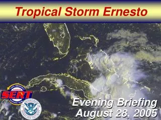
Case Study: Ernesto August–September 2006. Jared Klein – SUNY - Albany. 300 hPa Analyses : 1200 UTC 31 August 2006. Jet much farther downstream than with Ivan (2004). Precipitable water (mm), 300 hPa h (dam), wind speed (m s −1 ), and div (10 −5 s −1 ).

E N D
Case Study: Ernesto August–September 2006 Jared Klein – SUNY - Albany
300 hPa Analyses: 1200 UTC 31 August 2006 Jet much farther downstream than with Ivan (2004) Precipitable water (mm), 300 hPa h (dam), wind speed (m s−1), and div (10−5 s−1) 300 hPa frontogenesis [K (100 km)−1 (3 h)−1],θ(K), and wind barbs (kt) 1.0° GFS
300 hPa Analyses: 1200 UTC 1 September 2006 Precipitable water (mm), 300 hPa h (dam), wind speed (m s−1), and div (10−5 s−1) 300 hPa frontogenesis [K (100 km)−1 (3 h)−1],θ(K), and wind barbs (kt) 1.0° GFS
925 hPa Analyses: 1200 UTC 31 August 2006 WSI radar, 925 hPa θe (K) and wind barbs (kt) 925 hPa frontogenesis [K (100 km)−1 (3 h)−1],θ(K), and wind barbs (kt) 1.0° GFS
925 hPa Analyses: 1200 UTC 1 September 2006 Highest reflectivity near nose of LLJ/θe ridge axis Strong frontogenesis along warm frontal zone WSI radar, 925 hPa θe (K) and wind barbs (kt) 925 hPa frontogenesis [K (100 km)−1 (3 h)−1],θ(K), and wind barbs (kt) 1.0° GFS
925 hPa Q Vector Diagnosis: 0000 UTC 1 September 2006 Q Qn Qn div–con bands within coastal boundary as Ernesto nears landfall Strong forcing for descent–ascent associated with Qn and Qs div–con Qs Radar at 0000 UTC 1 September 2006 WSI radar 1.0° GFS Q vectors (10−10 K m−1 s−1 beginning at 2.5 × 10⁻¹¹), θ(K) contoured in green, and Q div–con (10−15 K m−2 s−1) shaded in cool–warm colors
925 hPa Q Vector Diagnosis: 0600 UTC 1 September 2006 Q Qn Qs Radar at 0600 UTC 1 September 2006 Highest reflectivity near strongest QG forcing for ascent WSI radar 1.0° GFS Q vectors (10−10 K m−1 s−1 beginning at 2.5 × 10⁻¹¹), θ(K) contoured in green, and Q div–con (10−15 K m−2 s−1) shaded in cool–warm colors
925 hPa Q Vector Diagnosis: 1200 UTC 1 September 2006 Q Qn Qs Radar at 1200 UTC 1 September 2006 Highest reflectivity near strongest QG forcing for ascent WSI radar 1.0° GFS Q vectors (10−10 K m−1 s−1 beginning at 2.5 × 10⁻¹¹), θ(K) contoured in green, and Q div–con (10−15 K m−2 s−1) shaded in cool–warm colors
Cross Section of Fn Magnitude: 0000 UTC 1 September 2006 Strongest frontogenesis focused near surface 925–500 hPa layer-avg Fn vectors (10−10 K m−1 s−1), θ (K) contoured in green, and Fn div–con (10−15 K m−2 s−1) shaded in cool–warm colors Fn magnitude [K (100 km)−1 (3 h)−1] shaded in green–blue, RH shaded in orange, θ(K) contoured in gray, wind barbs (ms−1), and ω<0 (µb s−1) contoured in red 1.0° GFS
Cross Section of Fn Magnitude: 1200 UTC 1 September 2006 Strongest frontogenesis focused near surface 925–500 hPa layer-avg Fn vectors (10−10 K m−1 s−1), θ (K) contoured in green, and Fn div–con (10−15 K m−2 s−1) shaded in cool–warm colors Fn magnitude [K (100 km)−1 (3 h)−1] shaded in green–blue, RH shaded in orange, θ(K) contoured in gray, wind barbs (ms−1), and ω<0 (µb s−1) contoured in red 1.0° GFS
NPVU QPE 0600 UTC 1 September 2006 Heaviest 6-h precip along and on cold side of surface boundary 6-h precipitation (in) ending at 1200 UTC 1 September 2006 Fn vectors (10−10 K m−1 s−1 beginning at 1.0 × 10⁻¹⁰), θ(K) contoured in green, streamlines contoured in black, and Fn div–con (10−14 K m−2 s−1) shaded in cool–warm colors 1200 UTC 1 September 2006 ~0.6° surface data
NPVU QPE 1200 UTC 1 September 2006 Heaviest 6-h precip along and on cold side of surface boundary 6-h precipitation (in) ending at 1800 UTC 1 September 2006 Fn vectors (10−10 K m−1 s−1 beginning at 1.0 × 10⁻¹⁰), θ(K) contoured in green, streamlines contoured in black, and Fn div–con (10−14 K m−2 s−1) shaded in cool–warm colors 1800 UTC 1 September 2006 ~0.6° surface data