Download
1 / 30
300 likes | 395 Views
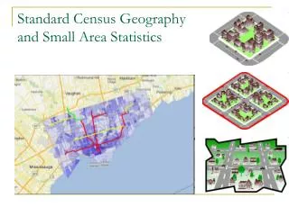
Small Area Statistics. (Tiny, tricky geographies, and the people who need them). Geography. Geography and Statistics: the ‘Where”. There’s always a ‘where’ (+ time + variables) The importance of the where varies depending on what you’re examining

E N D
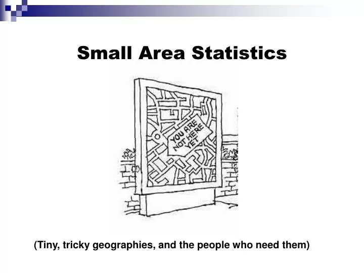
Small Area Statistics (Tiny, tricky geographies, and the people who need them)
Geography and Statistics: the ‘Where” • There’s always a ‘where’ (+ time + variables) • The importance of the where varies depending on what you’re examining • Like statistics, ‘where’ displays often spur new ‘why’ questions
Why learn about small area stats? • Small area statistics: • are essential for certain types of analyses • can be challenging to find, understand and to work with; • can answer local and very specific questions • can be expensive to produce and obtain (i.e. present access challenges)
Small Area Statistics Objectives today - to build understanding of: • The relationship between geography and statistics • The terminology and hierarchical structure of Census geography, to understand commonly accessible smaller units • Other small geographical units important to statistical display which are important/frequently requested • How to use key Statistics Canada tools to find or generate spatial display of statistics
What are ‘small area statistics’ about? • High demand for information at the ‘lowest geographic level available’ • Statistics at sub-provincial, or sub-municipality level, are critical to analyses of: • health (e.g. spread of disease), • housing, crime, social issues (e.g. emerging patterns of concern or interest), • emergency preparedness (analysis of this doesn’t work at a whole-municipality level), • market analysis, (why do they want my postal code anyway?) • and much, much more!
Privacy and confidentiality • Keeping the unit of analysis anonymous is a challenge with small area information (if one has good local knowledge, you can identify a person) • There are rules in place about what population counts are required in order for small area statistics to be released (e.g. income)
Expense and access • Authoring agencies, because of budget limitations, (‘priorities’) are always balancing availability of variable detail and finer levels of geography
Expense and Access • More variables? > $$$ • Smaller geography? > $$$ !! • No access/distribution infrastructure in place • Simply not available or collected
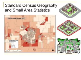
Geographic display • What can a map display do that a listed table cannot? • Summarize the big picture – with a picture • Rapidly show PATTERNS of disparity that might have some unexpected explanation • Allow display of statistics without knowledge of coding structure for viewers
Brief words on: why Geographic Information Systems? • Small area statistics are not easily read in tables • Graphic display becomes much more important at smaller levels • GIS increasingly used as a tool for small-area analysis and summary
Geographic displays of stats always involve choices, too • Simple shade of color choices imply different meanings • Ranges of statistics (‘breaks’ in the data) can be manipulated to imply different things • Statistics can be left out of maps easily; what is missing? • Source statistics may be ‘bad’
Geographic displays of statistics are subject to metadata review • Evaluation of an online map display is as required as an evaluation of statistics via metadata review; metadata criteria also apply to maps (sources should be cited, survey specified; see yesterday’s slide)
The Census Geography Hierarchy • Organizing a national system of statistical reporting depends on a full-coverage nested geographic hierarchy; i.e. geography/GIS for StatsCan is about more than making maps • The hierarchy helps to ensure 100% coverage of the population during Census collection by organizing the country’s geography • The hierarchy also defines ‘level’ of the release of statistics • Small area statistics exist at the ‘bottom’ (yet $$) end of the hierarchy
Great StatsCan Geography Tools for understanding hierarchy Nice quick tutorial: • http://geodepot.statcan.ca/Diss/Reference/Tutorial/HC_tut1_e.cfm Fantastic glossary: http://geodepot.statcan.ca/Diss/Reference/COGG/Index_e.cfm
A brief hierarchy overview • All levels of the hierarchy have definitions and corresponding codes • Eg. Canada – 00; Alberta (Province) – 48 • The levels and codes have defined relationships • Below provinces, we have Census Divisions: eg 4801 • Below provinces, Census Metropolitan Areas and Census Subdivisions • Below those, Census tracts and Dissemination Areas (SMALL AREA STATISTICS)
Hierarchy continued • Hierarchy is defined administratively (ie political decision) and statistically (ie StatsCan’s reporting requirements) • Not everything in the hierarchy relates to every other unit (see chart); i.e. not a straight, linear hierarchy • Eg. Forward Sortation Areas • “Odd” units (to StatsCan): ‘Designated Places’
Hierarchy applied to statistics • Not all statistics are available for all levels of the hierarchy; parts of the hierarchy may not exist in some places • Statistical analysis is more appropriately applied to some units than to others: eg. CMA vs CSD
Hierarchy and Small Area Statistics • What are the important small area statistics in the hierarchy? • Most commonly: Census Tracts and Dissemination Areas
Other small-area data units • What people want re: geography is often not the unit of geographic availability • Data typically compiled into statistics to meet the needs of the authoring organization • Who ELSE cares about these areas/what demands are in place for this information? • Solutions are available! (We’ll look at some)
Neighbourhoods • Frequent need for statistics at this level of geography • Census tracts vs. neighbourhoods • Municipalities: purchasing profiles and sharing agreements
Postal Codes • Frequently requested for market analysis/business applications • Represented graphically by dots in a product called the Postal Code Conversion File (PCCF) • Postal codes are regions! • The PCCF allows matching of postal codes to the best corresponding dissemination area
“Unavailable” Statistics Canada geographic areas • Some data resellers ‘impute’ or calculate estimates of ‘missing data values’ for small area statistics
GeoSuite: Walk-Through Exercise Click-along with Leah!
Exercise: Explore the hierarchy and statistics for your favorite geographic area using StatsCan Tools • Start here: • http://geodepot.statcan.ca/Diss/Maps/Maps_e.cfm • Explore the three sources available and evaluate them for usability, metadata, and for what information they have to offer you: • What were you able to discover about your chosen area from each source? • To what level of geography were you able to reach using each source?