Download
1 / 13
130 likes | 168 Views
Learn about weather symbols and station models, the universal language of weather forecasting. Explore different types of fronts, air masses, and station model practice to interpret temperature, air pressure, wind speed, and more. Get insights into how symbols provide a snapshot of weather in specific locations.

E N D
Why do we use Symbols? • Less space • Universal language • Why do we use station models • Gives us a small picture of weather in a certain location.
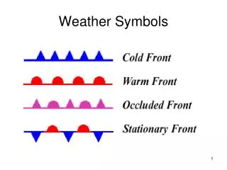
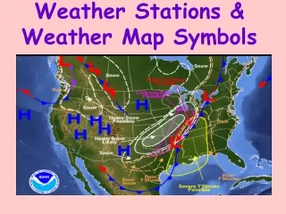
Fronts • Four types • Warm • Cold • Occluded • Stationary • Boundaries where air masses meet
Fronts • Cold Fronts • Cold air forced down • Warm air rising • Fast • Stormy rainy • Cumulonimbus clouds
Fronts • Warm Fronts • Warm air gradually replaces cold air • Slower • Light rain then clear skies • Warmer temps.
Fronts • Occluded • Air mass over taken by cold air mass • Rainy • Cool temps
Fronts • Stationary Fonts • A cold air mass meets a warm air mass and nothing really happends • Weather is like that of a warm front • Light rain • Warm temps • Then clear
Air Masses • Low Pressure • Weather is usually rainy, cloudy • Air pressure is around 29.ish
Air Masses • High Pressure • Weather is usually sunny clear and dry
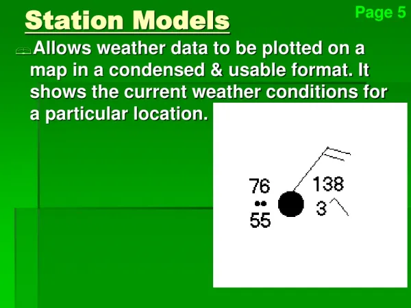
Station Models Air Pressure Temperature • These are blocks that contain a glimpse of weather information about a certain location at a specific time. • Includes • Temperature • Air Pressure • Cloud Coverage • Wind speed & Direction • Dew Point • Observed Weather 32 30.46 Observed Weather Cloud Coverage 15 Wind Speed Dew Point
Station Models • There are a number of symbols to represent different information on a station model
Station Model Practice • http://cimss.ssec.wisc.edu/wxwise/station/page5.html • http://itg1.meteor.wisc.edu/wxwise/AckermanKnox/chap1/decoding_surface.html • http://www.clccharter.org/donna/weather/weatherstation.htm