Download
1 / 30
300 likes | 464 Views
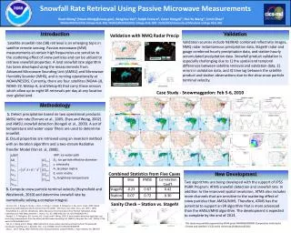
Retrieving Snowfall Rate from Satellite Measurements. Huan Meng 1 , Ralph Ferraro 1 , Banghua Yan 1 , Cezar Kongoli 2 , Jun Dong 2 , Nai -Yu Wang 2 , Limin Zhao 1 1 NOAA/NESDIS 2 Earth System Science Interdisciplinary Center, UMCP. Why do Snowfall Rate Retrieval.

E N D
Retrieving Snowfall Rate from Satellite Measurements HuanMeng1, Ralph Ferraro1, Banghua Yan1, CezarKongoli2, Jun Dong2, Nai-Yu Wang2, Limin Zhao1 1NOAA/NESDIS 2Earth System Science Interdisciplinary Center, UMCP
Why do Snowfall Rate Retrieval • Importance of snowfall rate data • Snowfall is a major form of precipitation in mid and high latitudes • Many applications: weather forecast, aviation, hydrology, water resources, transportation, agriculture, climate studies, etc. • Provide much needed winter precipitation estimates to blended global precipitation products • Inadequate snowfall observations/estimations • Few snowfall data sources • Gaps in radar and station coverage • Quality issues with radar and station snowfall data • Development of satellite snowfall rate product falls far behind rain rate products • Many existing satellite rainfall products with a wide range of applications
Satellites and Sensors • Satellites: NOAA and EUMETSAT polar-orbiting satellites: NOAA-18, NOAA-19, Metop-A, and Metop-B • Sensors: Advanced Microwave Sounding Unit-A (AMSU-A); Microwave Humidity Sounder (MHS) • Twenty combined channels, 23 – 190 GHz • Frequencies are respectively sensitive to temperature, water vapor and surface • Cross track scanning, variable footprint size NOAA-18 AMSU-A1 AMSU-A2 MHS
Pattern of Satellite Measurements • Each satellite orbits the earth 14 times a day • Usually overpasses each location twice a day, once going from the south to the north or ascending, and once from the north to the south or descending, with about 12 hours between the two overpasses • Each orbit takes 102 minutes, i.e. neighboring orbits are 102 min apart • Takes 2-3 orbits to cover CONUS Descending Overpasses 1:30 AM LST Equator Crossing Time Ascending Overpasses 1:30 PM LST Equator Crossing Time
AMSU/MHS Snowfall Rate Product • Satellite retrieved liquid equivalentsnowfall rate (SFR) over land • Need snow to liquid ratio to convert to solid snow • The ratio is dependent on local climatology and environmental conditions such as temperature and water vapor profiles • Typical snow ratio is 10:1 but can range from 5-25:1 or an even wider range • Four polar-orbiting NOAA POES and EUMETSAT Metop satellites can provide eightSFR retrievals a day in mid-latitudes that are grouped into 4 morning overpasses and 4 afternoon overpasses • SFR resolution is 16 km at nadir and 26 km x 52 km at limb • Maximum liquid equivalent snowfall rate is 0.2 in/hr(i.e. 2 in/hr solid snow with a 10:1 ratio); minimum is 0.004 in/hr (will miss very light snow) SFR Radar Reflectivity
Snowfall Rate Images • AWIPS SFR files from SPoRT for a product • evaluation project • Research webpage: http://www.star.nesdis.noaa.gov/corp/scsb/mspps_backup/sfr_realtime.html • Near real-time images with time stamps • Both SFR and rain rate images are available. The latter can be used to find orbital gaps • Access to an archive of images going back to January 1, 2012 • Research page: no real time support; algorithm updates periodically time stamp – represents the time the satellite overpasses the middle latitude line of the image, e.g. 37.5 for this image
Algorithm Methodology • Detect snowfall areas • Retrieve cloud properties with an inversion method • Compute snow particle terminal velocity and derive snowfall rate
Snowfall Detection (1/2) • Start with two products: AMSU snowfall detection (SD) (Kongoliet al., 2003) and AMSU rain rate (RR) (Ferraro et al., 2005; Zhao and Weng, 2002). Recently, a new SD algorithm has been developed and implemented. • Apply filters (based on GFS T and RH profiles) to RR and SD to determine snowfall (Foster, et al., 2011) • Both SD and RR algorithms rely on the scattering signal caused by ice particles to detect precipitation. Scattering depresses the microwave measurements. The SFR algorithm employs the same principle. NMQ snow only SFR w/ the new SD NMQ (radar) Phase POD = 73% NMQ all precipitation
Snowfall Detection (2/2) • Snow event in the Midwest, February 1, 2011. Comparison of satellite retrieved snowfall (rain retrieval not included) and ground observation of snow vs. rain The algorithm has the ability to differentiate between rain and snow correctly in most cases.
Retrieval of Cloud Properties • Inversion method • Simulation of brightness temperatures (Tb) with a Radiative Transfer Model (RTM) (Yan et al., 2008) • Use multiple channels • Iteration scheme with ΔTbithresholds • Ic and Deare retrieved when iteration stops Ic: ice water path De: ice particle effective diameter i: emissivity at 23.8, 31.4, 89, 157, and 190.31 GHz TBi: brightness temperature at 23.8, 31.4, 89, 157, and 190.31 GHz A: derivatives of TBi over IWP, De, and i E: error matrix
Snow Particle Terminal Velocity • Model by Heymsfieldand Westbrook (2010): : dynamic viscosity of air, Re: Reynolds number, a : air density, D: maximum dimension of the ice particle • Re = f(Ar), area ratio Ar= A/(D2/4); Ar= 1 for spherical ice particle • Assume spherical ice particles in this study
Snowfall Rate • Assumptions about snow microphysical properties • Spherical habit, number density of ice particles follows exponential distribution, fixed ice particle density • An adjusting factor to compensate for non-uniform ice water content distribution in cloud column • Model , Integration is solved numerically
MHS Tb Weighting Functions • Each frequency has its unique weighting function • C1, C2, and C5 are sensitive to ice scattering and are used in the SFR algorithm • Weighting functions for these channels peak at different atmospheric levels • By using these channels, SFR represents the snowfall in an integrated precipitation layer rather than at the surface C1: 89 GHz C2: 157 GHz C3: 183.31±1 GHz C4: 183.31±3 GHz C5: 190.31 GHz
Christmas Day SnowstormDec 25-27, 2010 SFR (mm/hr)
Validation of AMSU/MHS SFR • Validate over contiguous United States • Validation Sources • Station hourly accumulated precipitation data • StageIV radar and gauge combined hourly precipitation data • National Mosaic & Multi-Sensor QPE (NMQ) instantaneous radar precipitation data • Validation challenges • Spatial scale difference with station data: 16+ km footprint vs. point measurement • Temporal scale difference with station/StageIV data: instantaneous vs. hourly • Other issues with ground observations and radar snowfall data • Quality issues: station data with undercatch (underestimation) due to dynamic effect; NMQ data with positive bias. • StageIV/NMQ: Range effect, overshooting, beam blockage, overestimation at the presence of melting snowflakes, etc.
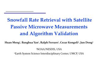
Validation with StageIV and Station Data • Five large-scale heavy snowfall events from 2009-2010 • Jan 27-28, 2009 • Mar 23-24, 2009 • Dec 08-09, 2009 • Jan 28-30, 2010 • Feb 05-06, 2010 • The events cover diverse geographic areas and climate zones
Case Study: Dec 8-9, 2009 (1/3) • A large snowstorm system in the Midwest • Heavy snowfall (1’+) in NE, IA, MN, WI • Blizzard condition, winds > 45 mph Before After
Case Study: Dec 8-9, 2009 (2/3) • Time series of SFR areal mean vs. StageIV and station data • Mean SFR evolution agrees well with Stage IV and station data • Mean SFR is generally lower than the validation data except with station data at the later stage of the storm • Scatter plots further supports the agreements Station vs SFR StageIVvs SFR
Case Study: Dec 8-9, 2009 (3/3) • Histogram Images of matching data SFR & Station SFR & StageIV StageIV • Statistics SFR
Summary Statistics • Combined statistics from all five events • Sanity check - Comparison between StageIV and Station • SFR generally has better statistics against each of the validation sources than between the two sources
Validation with NMQ Data (1/2) • Validation with NMQ instantaneous radar precipitation rate • NMQ (Q2) radar only data: 0.01 degree, every 5 minutes • Better comparability in spatial (radar weighted average) and temporal collocations between satellite and radar • NMQ has considerable positive bias against StageIV Satellite NMQ (Radar)
Validation with NMQ Data (2/2) Time series of areal mean snowfall rate from satellite and radar Time series of bias and correlation coefficient between satellite and radar snowfall rate
Product Applications • Identify snowstorm extent and the location of the maximum intensity within the storm • Provide quantitativesnowfall information to complementsnowfall observations or estimations from other sources (stations, radar, GOES imagery data etc.) • Fill observational gaps in mountains and remote regions where weather stations are sparse and radar blockage and overshooting are common • Locate snowstorms at higher latitudes where the quality of the subjective GOES IR and VIS imagery data deteriorates • Track storms and derive trending information (e.g. strengthening or weakening of the storm) by pairing with GOES IR/VIS/WV images to
What to be Aware of • This is a liquid equivalent snowfall rate • There usually is a time lag between the retrieved SFR and the best correlated ground observation, due to the slow terminal velocity of snow particles • Satellite microwave signal can penetrate cloud, so SFR represents snowfall throughout the precipitation layer • The current product is limited to regions where the surface air temperature is about 22°F and above • Extension to colder climate is currently under development • Not applicable to lake effect snow • The resolution of the product is too coarse to detect the narrow snow band of lake effect snow • Misses very light snowfall due to a minimum SFR limit • Polar-orbiting satellite product with latency of 30 min – 3 hrs
Use Case 1 – Tracking Snowstorm Hard to determine snowing clouds from GOES Difficult to tell rain from snow in radar SFR Product at 17:05Z Snow max later rotated and moved north Snow edge and max intensity easy to infer GOES IR image at 17:00Z Radar at 17:06Z • How do I use the SFR Product? • SFR adds additional information to radar and GOES data • SFR makes it easy to identify edge of snowfall and area of maximum intensity • The movement and strength of a feature identified in SFR can be tracked using radar or GOES imagery between satellite overpasses • In addition, radar and GOES images can also be used to infer storm trending information SFR Product at 19:40Z
Use Cases 2 & 3 – Filling Radar Gaps Higher elevation rain does not appear on SFR product SFR retrieval over an area in radar gap during a snow event in Newfoundland, Canada on November 29, 2012 Mono Lake x Lee Vining x x x June Lake Mammoth Lakes NEXRAD Composite Reflectivity & SFR NEXRAD Composite Reflectivity
SFR from Next Generation Microwave Sensor • Advanced Technology Microwave Sounder (ATMS) • Follow-on microwave sensor to AMSU and MHS • Onboard S-NPP (launched in October 2011) and the future JPSS satellites • More snow-sensitive channels and better sampling configuration than AMSU/MHS for improved snowfall retrieval • ATMS SFR • Complete baseline algorithm by the end of 2013 • Currently under final calibration and validation • Increase SFR retrievals to 10 times a day, 5 in the morning and 5 in the afternoon • Future development • Extension to colder climate • Improvement to SFR utility
Preliminary ATMS SFR Validation • ATMS Snowfall Rate • Show agreement with AMSU/MHS SFR in basic patterns • Might have higher false alarm rate, still under validation • Preliminary validation result: AMSU/MHS, 8:37Z ATMS 8:05Z
Product Summary • SFR is liquid equivalent snowfall rate • SFR uses observations from microwave sensors aboard polar orbiting satellites • Currently eight SFR retrievals a day grouped into 4 morning and 4 afternoon overpasses • ATMS SFR is under validation. Will add 2 more SFR retrievals a day • Most important SFR applications: • Identify snowstorm extent and area with the most intense snowfall • Fill gaps in radar coverage and ground observations