Download

1 / 8
80 likes | 95 Views
Explore the use of sensor web technology for flood and volcano detection and monitoring utilizing data from Dartmouth Flood Observatory and University of Hawaii. Learn how remote sensing aids in assessing surface water conditions and detecting volcanic activity. Enhance your understanding of flood warnings, flood hazard reduction, and volcanic eruption detection through orbital remote sensing techniques.

E N D
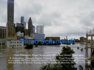
Flood Sensorweb Uses Dartmouth Flood Observatory QUIKScat Global Flood Atlas: B. Brakenridge, Anderson, Ngiem, Caquard, et al., “Flood Warnings, Flood Disaster Assessments, and Flood Hazard Reduction: The Roles of Orbital Remote Sensing,” Proc 30th Intl Symp on Remote Sensing of the Environment, Honolulu, HI, Nov 10-14, 2003
Floods - Detection Dartmouth-Flood Observatory QuikSCAT • The DFO in collaboration with JPL/QuikSCAT processes QuikSCAT Scatterometer data to assess surface water conditions. • VV/HH ratio is used to assess surface water properties of the areas in 0.25 lat/lon degree bins • The 7 day running mean is used to dampen effects of short-duration rainfall over urban areas. • This data is then compared to the seasonal (90 day) average of the previous year to screen out wetlands. POC: Brakenridge/DFO Ngiem/JPL
Flood alerts are then used to retask EO-1. EO-1 Hyperion Image Brahmaputra Aug 6, 2003 MODIS Image Brahmaputra, India Aug 6, 2003 250M resolution (10M ALI Pan band possible) 30M resolution
Impact Higher resolution data is acquired of: • key locations (pre-determined satellite gauging reaches) and • times (active flooding regions) With the end result of improved flood science.
Status - Floods • September, October 2003 - Several demonstrations performed to track flooding in the Brahmaputra River basin, India • December 2003 – continued demonstrations to track Yellow River, China
Volcano Sensorweb Uses University of Hawaii, Hawaii Institute for Geophysics & Planetology detectors: Harris, A. et al., (2002) Web-Based Hot Spot Monitoring using GOES: What it is and How it Works,Advances in Environmental Monitoring and Modelling http://www.kcl.ac.uk/advances Vol. 1 No. 3 (2002) pp.5-36 Wright, R., Flynn, LP, Garbeil, H, Harris, AJL, and Pilger, E. (2002). Automated volcanic eruption detection using MODIS.Remote Sensing of Environment, 82, 135-155. Flynn, LP, Wright, R, Garbeil, H, Harris, AJL, and Pilger, E. (2002). A global thermal alert using MODIS: initial results from 2000-2001.Advances in Environmental Monitoring and Modeling, 1, 5-36.
Volcano Sensorweb Earth Observer One Re-tasking GOES, MODIS, AVHRR Triggers
Status - Volcanoes • Demonstrations in progress using MODVOLC • Recent triggers of • Kilauea, HI; • Belinda, Antarctica • SGM /GOES & AVHRR linkup in progress • End impact is • larger archive of active volcano remote sensing imagery • Increased imagery of early phenomena imagery