Download
1 / 42
430 likes | 592 Views
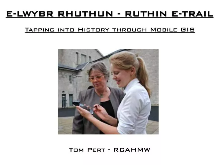
E-LWYBR RHUTHUN - RUTHIN E-TRAIL. Tapping into History through Mobile GIS. Tom Pert - RCAHMW. The Royal Commission on the Ancient and Historical Monuments of Wales is the national organisation responsible for recording archaeological and architectural sites in Wales.

E N D
E-LWYBR RHUTHUN - RUTHIN E-TRAIL Tapping into History through Mobile GIS Tom Pert- RCAHMW
The Royal Commission on the Ancient and Historical Monuments of Wales is the national organisation responsible for recording archaeological and architectural sites in Wales. The Royal Commission was established in 1908 by Royal Warrant and is now sponsored by the National Assembly for Wales.
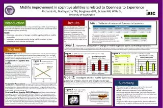
Comisiwn Brenhinol Henebion CymruRoyal Commission on the Ancient and Historical Monuments of Wales 33 staff, including 12 ‘Investigators’ 70,000 sites or buildings recorded 1.5 million images 80 books published in on-going publishing programme Advanced electronic access for the public through Coflein High quality teams of internationally-recognised experts Centre of excellence in vernacular architecture industrial archaeology aerial photography digital mapping electronic delivery education and outreach
COFLEIN – the National Monuments Record of Wales on-line database. • Photographs • Drawings • Plans • Reports • Descriptions www.coflein.gov.uk
GIS at the RCAHMW NMRW sites database GPS survey of Banc Du enclosure Montgomery 3D GIS Hill slope analysis of Hill Fort, Montgomery E-Lwybr Rhuthun - Ruthin E-Trail
Norton Interrupted Ditch Enclosure, nr St Brides Major, Vale of Glamorgan
Norton Interrupted Ditch Enclosure, nr St Brides Major, Vale of Glamorgan
The Starting Point. E-Lwybr Rhuthun - Ruthin E-Trail
In-house trial – Uplands Survey E-Lwybr Rhuthun - Ruthin E-Trail
In-house trial – Uplands Survey E-Lwybr Rhuthun - Ruthin E-Trail
E-LWYBR RHUTHUN - RUTHIN E-TRAIL Partners E-Lwybr Rhuthun - Ruthin E-Trail
Ruthin E-Trail - Aims of the project • Deliver heritage information in new and innovative way to a wider audience • Introduce Welsh Baccalaureate students to the fundamentals of GIS, GPS and mobile technology • Enable students todevelop measurable key skills which will count towards their attainment of the Welsh Baccalaureate • Develop our understanding of how to deliver Coflein information to mobile devices E-Lwybr Rhuthun - Ruthin E-Trail
Basic Equipment Compact Flash GPS Receiver AquaPac Waterproof bag HP IPAQ PDA ESRI ArcPad Mobile GIS E-Lwybr Rhuthun - Ruthin E-Trail
Using the E-TRail Tap on any of the highlighted buildings to access information and images from the Denbighshire Record Office and RCAHMW’s COFLEIN web service. Tap E-Lwybr Rhuthun - Ruthin E-Trail
Proximity Alerts GPS technology enables your position to be displayed on the map, which scrolls in real time as you walk around the town. Information alerts are triggered by your position providing directions, facts or questions. E-Lwybr Rhuthun - Ruthin E-Trail
Brynhyfryd Students visiting the Record Office E-Lwybr Rhuthun - Ruthin E-Trail
Alun Pugh AM launching the Ruthin E-Trail, 9th September 2005 E-Lwybr Rhuthun - Ruthin E-Trail
Brynhyfryd students using the Ruthin E-Trail during the Heritage Weekend 17th - 18th September 2005 E-Lwybr Rhuthun - Ruthin E-Trail
Welsh Baccalaureate Students at Ysgol Brynhyfryd, Ruthin, using ArcPad GIS for the first time. By April they will have created their own E-Trails. E-Lwybr Rhuthun - Ruthin E-Trail
Future Development • Directional querying E-Lwybr Rhuthun - Ruthin E-Trail
Not only where but what Enhanced LBS Specific Location/direction-based queries E-Lwybr Rhuthun - Ruthin E-Trail
Future Development • Directional querying • Thematic trails • Enhanced interactivity • Audio & visual interpretation • Tailoring to audience • Geocache/treasure Hunt trails E-Lwybr Rhuthun - Ruthin E-Trail
Geocaching Shropshire County Council “Time Trails” E-Lwybr Rhuthun - Ruthin E-Trail
Next area for E-Trail Development • Complex multi-period industrial landscape • Confusing mix of surviving archaeology and • destroyed features • Variety of industrial processes • Large collection of archive material and GIS data
Almost 2000 National Monuments Record sites within World Heritage Site boundary
Furnace 4 Blaenavon Ironworks
Coflein Mobile wireless delivery of Coflein data to non software-specific mobile devices E-Lwybr Rhuthun - Ruthin E-Trail
National portal for historic environment records 2004 Coflein – National Monuments Record for Wales
National portal for historic environment records 2004 Coflein – National Monuments Record for Wales 2006 NMWMAP - National Museum of Wales archaeology collections
National portal for historic environment records 2006 – a ‘one-stop shop’ for the historic environment data The National Trust – sites and buildings data Cadw – Statutory Listing and Scheduling records Welsh Archaeological Trusts – Sites and Monuments Records National Museum of Wales – industrial artefacts, site records National Library of Wales – topographical pictures Local record offices – maps and documents Communities@One initiative – social inclusion Local museums – site-specific artefacts
E-LWYBR RHUTHUN - RUTHIN E-TRAIL Tapping into History through Mobile GIS E-Lwybr Rhuthun - Ruthin E-Trail