Download
1 / 20
210 likes | 257 Views
Delve into the intricate world of surface water in Pennsylvania, from the journey of precipitation through river systems to the distinct drainage patterns shaping the landscape. Discover how watersheds define the boundaries of each unique basin and learn how to delineate them accurately.

E N D
Where Does the Water Go? Precipitation Percolates into Soil/rock Runoff ____________ _____________ Lakes, ponds, streams Ocean, wetlands
52% 8% Surface Water 38% 1% 1%
River Systems __________ Collects ________: Tiny water channels Merge ________________ Merge _________ Empty _________
River System • _________________: Network of rivers and streams draining a river basin • _____________: Feeder streams • Major River Systems • _______________ • ________________ • ________________ • _________________
Susquehanna (Main) Susquehanna (West) Delaware Schuylkill Juniata Lehigh Ohio Allegheny Monongahela Lackawaxen Lackawanna Youghiogheny Shenango Clarion Pennsylvania’s Major Rivers
Major Drainage Patterns • Drainage patterns depend on: • ___________________: Physical characteristics of the land. • Rocks over which the water travels
Types of Drainage Patterns • ______________: Resembles a mature tree • Most river systems in PA • Main river forms trunk • Uniform bedrock • Function of the slope of the land
Types of Drainage Patterns • ____________: “Spokes on a wheel” • Streams flow from a high central area • __________ • __________
Types of Drainage Patterns • ______________: • Rock broken by a series of faults and fractures • “Bends” in stream form right angles
Types of Drainage Patterns • _____________: • Type of rectangular • Tributary streams are parallel to each other • Rock alternate between hard and soft
Types of Drainage Patterns • ______________: • Large body of water (lake) at the center • “Feeder Streams” empty into the lake
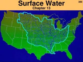
Watersheds (Drainage Basin) • Watersheds: The area of land that is drained by a river. • Surrounded by topographic highs called Divides. • Divide: Any ridge between two streams along which precipitation runs off. • PA has 104 watersheds
Watersheds (Drainage Basin) • 6 Major PA Watersheds • _________________ Basin • ______________ River Basin • ___________________ Basin • ____________________ Basin • _____________________ Basin • _____________________ Basin
Identifying the Boundaries of a Watershed (Delineation) • Step #1: Identify the stream to be delineated. • Step #2: Using a pencil and ruler, draw a series of lines (1-2 cm in length) perpendicular to the stream, spaced 1 cm apart. • Step #3: At the headwaters, draw several lines radiating outward. • Step #4: Follow the perpendicular lines drawn and find the highest elevation that is closest to the steam.
Identifying the Boundaries of a Watershed (Delineation) • Step #5: Place an “X” at the highest elevation point. • Step #6: Repeat steps #4 & #5 for all of the perpendicular lines drawn. • Step #7: Connect the “X’s” to outline the boundary of the watershed.