Download
1 / 36
360 likes | 370 Views
Learn how to assess and trust model forecasts through comprehensive NWP training. Explore model-specific info and case studies to enhance forecast interpretation. Improve prediction accuracy by understanding the black box of forecasting.

E N D
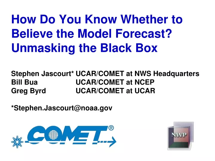
How Do You Know Whether to Believe the Model Forecast? Unmasking the Black Box Stephen Jascourt* UCAR/COMET at NWS Headquarters Bill Bua UCAR/COMET at NCEP Greg Byrd UCAR/COMET at UCAR *Stephen.Jascourt@noaa.gov
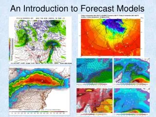
Example: Model runs from 00 UTC 8 Oct 2007 Fire weather danger over northeast Nevada? How Do You Know Whether to Believe the Model Forecast? NAM 48-h forecast at Elko, NV SREF 48-h probability [no precip, RH<20%,wind>20MPH,T>60F] X Elko RH? Forecast T, mixing depth NOAA/NCEP
Example: Model runs from 00 UTC 8 Oct 2007 Position, strength of lakes cut-off? Frost potential? How Do You Know Whether to Believe the Model Forecast? 2-m T oC 84 h valid 12Z Oct 11 GFS NOAA/NCEP GFS ensembles 72 h valid 00Z 11 Oct 500 hPa 558 dm NAM NOAA/NCEP NOAA/NCEP NOAA/NCEP
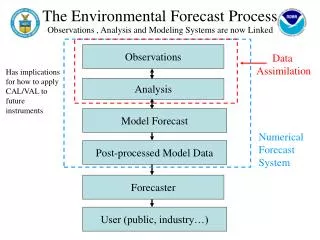
UNMASKING THE BLACK BOX 8 years of NWP training Navigation, how to find it • MetEd site • Operational Models Matrix • Individual NWP models, ensembles, wave models • NWP Course (conceptual background) • Model-specific information • Forums • Ensemble module • Case examples – what happened, why • VISITview teletraining – integrates content, cases • COMET Webcast modules – integrates content, cases • Seasonal Powerpoints – summaries, cases
NAVIGATIONOperational Models Matrix www.meted.ucar.edu/nwp/pcu2/
NAVIGATIONOperational Models Matrix www.meted.ucar.edu/nwp/pcu2/
NAVIGATIONOperational Models Matrix www.meted.ucar.edu/nwp/pcu2/
Navigation panel Content panel NWP COURSE
Content is updated as models change! NAVIGATIONOperational Models Matrix www.meted.ucar.edu/nwp/pcu2/
NAVIGATIONOperational Models Matrix www.meted.ucar.edu/nwp/pcu2/
NAVIGATIONOperational Models Matrix www.meted.ucar.edu/nwp/pcu2/
NAVIGATIONOperational Models Matrix www.meted.ucar.edu/nwp/pcu2/
NAVIGATIONOperational Models Matrix www.meted.ucar.edu/nwp/pcu2/
NAVIGATIONOperational Models Matrix www.meted.ucar.edu/nwp/pcu2/
NAVIGATIONOperational Models Matrix www.meted.ucar.edu/nwp/pcu2/
NAVIGATIONOperational Models Matrix www.meted.ucar.edu/nwp/pcu2/
NAVIGATIONOperational Models Matrix www.meted.ucar.edu/nwp/pcu2/
Navigation panel Content panel MODULES Ensemble Forecasting Explained
NAVIGATIONCases www.meted.ucar.edu/nwp/pcu3/cases/
CASESHow Good Data Can Lead to a Poor Model Analysis Navigation panel Content panel
CASESHow Good Data Can Lead to a Poor Model Analysis Smooths out changes to first guess 5-10 oC cooler than first guess nearly same as first guess
NAVIGATIONVISITview Teletraining http://rammb.cira.colostate.edu/visit/topic_nwp.html
Lake-effect heavy snow, why good forecast? VISIT SESSIONSNAM-WRF Update and Performance Discussion
WEBCASTS Using the WRF Mesoscale Model [AFWA] Lots of data shown, user challenged to explain, predict, and verify during the module
Model change summary and forecast impacts WEBCASTS The NCEP NAM WRF Model
Precipitation type algorithm change: affects diagnosed type WEBCASTS The NCEP NAM WRF Model
“Convective Weather Refresher” under “Convective Weather” topic on MetEd home page SEASONAL TRAINING Convective Parameterization
SUMMARY 8 years of NWP training Navigation, how to find it Start: MetEd site www.meted.ucar.edu Register (free), log in Select NWP under TOPICS Operational Models Matrix (www.meted.ucar.edu/nwp/pcu2/) • Individual NWP models, ensembles, wave models • NWP Course (conceptual background) • Model-specific information • Forums • Ensemble module Case examples (www.meted.ucar.edu/nwp/pcu3/cases/) COMET Webcast modules – integrates content, cases Seasonal Powerpoints – summaries, cases, content VISITview teletraining – integrates content, cases http://rammb.cira.colostate.edu/visit/topic_nwp.html