Download
1 / 174
1.74k likes | 1.87k Views
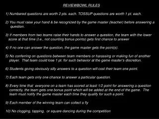
REVIEWBOWL RULES 1) Numbered questions are worth 2 pts. each. TOSSUP questions are worth 1 pt. Each. 2) You must raise your hand & be recognized by the game master (teacher) before answering a question.

E N D
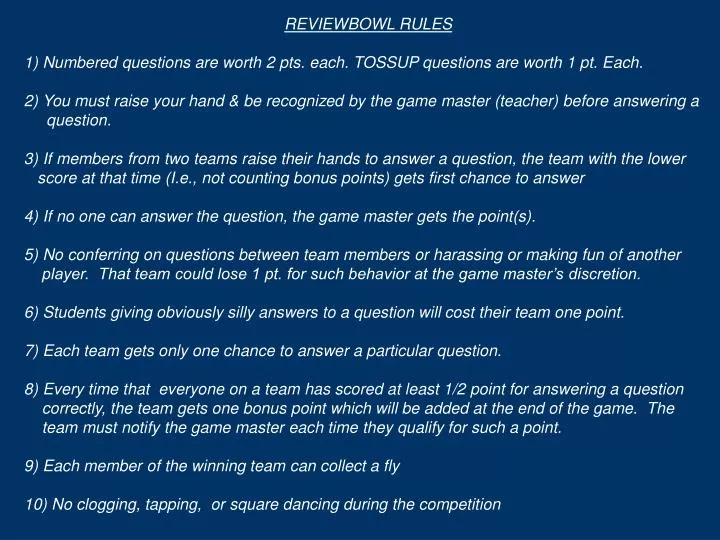
REVIEWBOWL RULES 1) Numbered questions are worth 2 pts. each. TOSSUP questions are worth 1 pt. Each. 2) You must raise your hand & be recognized by the game master (teacher) before answering a question. 3) If members from two teams raise their hands to answer a question, the team with the lower score at that time (I.e., not counting bonus points) gets first chance to answer 4) If no one can answer the question, the game master gets the point(s). 5) No conferring on questions between team members or harassing or making fun of another player. That team could lose 1 pt. for such behavior at the game master’s discretion. 6) Students giving obviously silly answers to a question will cost their team one point. 7) Each team gets only one chance to answer a particular question. 8) Every time that everyone on a team has scored at least 1/2 point for answering a question correctly, the team gets one bonus point which will be added at the end of the game. The team must notify the game master each time they qualify for such a point. 9) Each member of the winning team can collect a fly 10) No clogging, tapping, or square dancing during the competition
FC.16 THE CIVILIZATIONS OF PRE-COLUMBIAN AMERICA TO c.1500 C.E. Successful huntingNo large herds of big animals to domesticate N. & S. Amer. aligned on N-S axis Different climatesHard to spread crops & agr. Main domestic crop, corn, hard to develop from a grass to a plant yielding plentiful food Jungles & mts No contact b/w Peru & Mexico No sharing of ideas No draught power Smaller agr. yields to support civ. Few infectious diseases No resistance to European diseases Civ. comes later & spreads more slowly than in E. Hemisphere Civ’s develop separately in Mexico and Peru Mexico Peru
FC.80 GEOPOLITICAL FACTORS IN THE RISE OF W. EUROPE (c.1500-1900) W. Europe broken up by mountains & forests W. Europe has diverse climates & resources Many indep.states No 1 ruler can control all Europe Kings can’t control all of one resource or product Rise of a free middle class that can promote new ideas & tech or move to a state that will let them Balance of power shifts away from repressive toward tolerant states Cannot control the spread of the printing press or the ideas it promotes (FC.74) Rise of capitalist econ. & competitive spirit that encourages new tech’s (FC.75) W. Eur. develops new military technologies & techniques: More sophisticated fortifications that resist artillery & slow down invading armies Large bulky ships for ocean voyages Excellent gun platforms Very powerful navies Adapts newly redisc. Roman drill & march to new firearms tech. Most powerful armies on earth W. Eur. able to conquer large colonial emp’s w/small but well armed & disciplined armies & navies (FC.81) Influx of money to different countries in W. Europe W. Europe the center of a world economy Money & resources for the Industrial Revolution (FC.111) W. Eur. & Eur. derived cultures control 85% globe by 1900 (FC.122)
FC.81 THE AGE OF EXPLORATION (c.1400-1550) Towns & trade revive in 1100s (FC.64) Eur’s position at W. end of Eurasia Medieval religious fervor Middlemen raise cost of Asian goods Good for exploring Afr. & Atl. Ships & navig. tech. to sail ocean Desire for Eastern luxuries Desire to convert other cultures Interest in other cultures Secular ideas of Renaissance (FC.76) Incentive & means to find new route to Asia Desire to find Afr. source of Arab gold & legendary Chr. Kgd of Prester John Belief in round, but smaller world that is 7/8 land Trip to Asia only 3500 miles Spain & Portugal lead the way thanks to: Heritage of Arab geogr. knowledge Geogr. position on Atlantic & Medit. Portuguese, led by Prince Henry the Navigator, explore Afr. Coast to find gold Christopher Columbus, seeks backing for voyage to reach Asia by sailing west Castile & Aragon preoccupied until 1492 with driving out Moors Can’t back him Portuguese reach part of coast turning E. Think they can sail around Afr. to India Spain, wanting to beat Portugal to Asia, backs Columbus who discovers America instead Even after coast turns S. again, Portuguese continue exploring Dias rounds S. Afr. Fearing Spain will reach India 1st, Port. sends Vasco da Gama around Afr. To India (1498) Spain, realizing this is a new continent, tries to find way through or around it to Asia Serrao discovers Pacific Ocean for Portugal from the W. end (1513) while Balboa discovers it for Spain from the E. end in the same year Magellan sails around the world (1519-22) World much bigger than previously believed Portuguese reach China (1513) & Japan (1542) & establish missionaries & trade there Portugal builds SE Asian Empire to control spice trade (FC.82) Explorers still seek Great S. Continent & easy way to Asia (FC.83)
FC.82 THE PORTUGUESE EMPIRE IN EAST ASIA (1498-c.1600) Cut corners by not maintaining their ships Reach China (1513) & act as middlemen trading Spanish-Amer. Silver for Chinese silk Hostile Arabs control mkts No one wants Eur. goods Costly shipwrecks Portuguese return (1502) w/artillery on their big ships Defeat two Arab fleets & force Indians to trade Costly & hard to maintain Asian forts & fleet from Europe Portugal controls much of Asian spice & silk trade, but at huge cost: Hire half-trained Native crews to replace lost Eur. sailors Portuguese, under Alfonse De Albuquerque seize strategic points & straits to blockade Arabs & control spice trade: Overpack ships with spices to make more $ Seize Goa as their main base in India Seize Ormuz to cut off Persian Gulf Fail to seize Aden & cut off Red Sea Get Molucca Straits & Spice Islands Expensive wars & hostility of Muslim Mughal Emp. in India Huge drain on Portugal’s ltd. popul. & resources Portugal expels Jews No MC to handle $ Spices go to Antwerp Drastic cost-cutting measures: Portuguese reach India in 1498 & 1500 (FC.81) Long distance b/w Eur. & Asia Portugal’s ltd. pop. & resources Decline of Portuguese Emp. B y 1600 Dutch take over Far East trade (FC.93)
FC.83 FILLING IN THE GAPS: VOYAGES OF LATER EXPLORATION (c.1550-1900) Eng. Richard Chancellor reaches Russian port Archangel, but gets no further Search for NW Passage through N. Am. to Asia English explore Arctic regions of N. America Henry Hudson explores Hudson Bay (1610), but finds no NW Passage No practical NW Passage ever found Try to find Strait b/w Asia & N. Amer. Otherwise NE Passage would be useless Vitus Bering (Rus.) & later James Cook (Br.) find Bering Strait Continental interiors explored during 1800s thanks to railroads that can carry & supply large populations & vaccines to combat tropical diseases Various Dutch explorers also try, but fail to find NE Passage Passage found in 1878 & kept open by Russian ice breakers Spain, Britain & Russia explore & claim N America’s NW coast Explore S. Pacific to find Great Southern Cont. Dutch discover Australia & New Zealand Br. Capt. Cook shows they are islands, but fails to reach Antarctica Palmer finds Antarctica (1820) By early 1800s, most continental coastlines have been explored & mapped Search for NE Passage N. of Scandinavia State of geographic knowledge c.1500: Outline of S. Amer. & E. coast of N. Amer., existence of Pacific Ocean, & size of globe (FC.81) Railroads invented during Industrial Revolution (FC.112) Vaccines invented during Industrial Revolution (FC.117)
1) What did Europeans know correctly in 1400? Eur. & Medit., world is round
1) What did Europeans know correctly in 1400? Eur. & Medit., world is round 2) 3 misconceptions about the globe in 1400 & their importance?
1) What did Europeans know correctly in 1400? Eur. & Medit., world is round 2) 3 misconceptions about the globe in 1400 & their importance? Small world, 7/8 land, Great Southern Continent
1) What did Europeans know correctly in 1400? Eur. & Medit., world is round 2) 3 misconceptions about the globe in 1400 & their importance? Small world, 7/8 land, Great Southern Continent 3) 3 effects of Europe's position at far west end of Eurasia?
1) What did Europeans know correctly in 1400? Eur. & Medit., world is round 2) 3 misconceptions about the globe in 1400 & their importance? Small world, 7/8 land, Great Southern Continent 3) 3 effects of Europe's position at far west end of Eurasia? 1) Good position for exploring S & W 2) At end of network of middlemen trading w/Asia-> expensive -> incentive to find new routes 3) On the Atlantic-> Developed good Nautical tech.
1) What did Europeans know correctly in 1400? Eur. & Medit., world is round 2) 3 misconceptions about the globe in 1400 & their importance? Small world, 7/8 land, Great Southern Continent 3) 3 effects of Europe's position at far west end of Eurasia? 1) Good position for exploring S & W 2) At end of network of middlemen trading w/Asia-> expensive -> incentive to find new routes 3) On the Atlantic-> Developed good Nautical tech. 4) 3 effects of rise of towns & trade on Age of Exploration?
1) What did Europeans know correctly in 1400? Eur. & Medit., world is round 2) 3 misconceptions about the globe in 1400 & their importance? Small world, 7/8 land, Great Southern Continent 3) 3 effects of Europe's position at far west end of Eurasia? 1) Good position for exploring S & W 2) At end of network of middlemen trading w/Asia-> expensive -> incentive to find new routes 3) On the Atlantic-> Developed good Nautical tech. 4) 3 effects of rise of towns & trade on Age of Exploration? 1) Stimulated Eur. desire for Eastern luxuries 2) Stimulated Eur. interest in other cultures 3) Created wealth-> More secular outlook & interest in the world
Names of the two ship building techniques shown here? Clinker built (top) & carvel built
Names of the two ship building techniques shown here? Clinker built (top) & carvel built Where was each style practiced?
Names of the two ship building techniques shown here? Clinker built (top) & carvel built Where was each style practiced? Clinker in North & Carvel in the South
What was the Greek name for these creatures? Cynoscephelae (dog-heads)
What is the man in the middle doing? Using his single umbrella foot to shade himself from the sun
What is this instrument called and how does it work? Cross-staff, which measures latitude by moving the vertical stick until it aligns with the sun on the top & horizon on the bottom
13) Name & description of main sailing ship of age of exploration?
13) Name & description of main sailing ship of age of exploration? Carrack which used S. carvel constr. (end to end) but N. bulky hull, & used N. square sail for tail winds, but also had S. Lateen sails for tacking.
13) Name & description of main sailing ship of age of exploration? Carrack which used S. carvel constr. (end to end) but N. bulky hull, & used N. square sail for tail winds, but also had S. Lateen sails for tacking. 14) What is the coriolis effect?
13) Name & description of main sailing ship of age of exploration? Carrack which used S. carvel constr. (end to end) but N. bulky hull, & used N. square sail for tail winds, but also had S. Lateen sails for tacking. 14) What is the coriolis effect? Effect caused by earth’s spinning where trade winds, instead of blowing straight N or S, blow NW, SW, NE, or SE
13) Name & description of main sailing ship of age of exploration? Carrack which used S. carvel constr. (end to end) but N. bulky hull, & used N. square sail for tail winds, but also had S. Lateen sails for tacking. 14) What is the coriolis effect? Effect caused by earth’s spinning where trade winds, instead of blowing straight N or S, blow NW, SW, NE, or SE 15) Two countries that led in exploration & why?
13) Name & description of main sailing ship of age of exploration? Carrack which used S. carvel constr. (end to end) but N. bulky hull, & used N. square sail for tail winds, but also had S. Lateen sails for tacking. 14) What is the coriolis effect? Effect caused by earth’s spinning where trade winds, instead of blowing straight N or S, blow NW, SW, NE, or SE 15) Two countries that led in exploration & why?Spain & Portugal because they 1st received Arab geog. knowledge & were best placed for exploring south & west
13) Name & description of main sailing ship of age of exploration? Carrack which used S. carvel constr. (end to end) but N. bulky hull, & used N. square sail for tail winds, but also had S. Lateen sails for tacking. 14) What is the coriolis effect? Effect caused by earth’s spinning where trade winds, instead of blowing straight N or S, blow NW, SW, NE, or SE 15) Two countries that led in exploration & why?Spain & Portugal because they 1st received Arab geog. Knowledge & were best placed for exploring south & west 16) Portugal's original goals in exploring Africa?
13) Name & description of main sailing ship of age of exploration? Carrack which used S. carvel constr. (end to end) but N. bulky hull, & used N. square sail for tail winds, but also had S. Lateen sails for tacking. 14) What is the coriolis effect? Effect caused by earth’s spinning where trade winds, instead of blowing straight N or S, blow NW, SW, NE, or SE 15) Two countries that led in exploration & why?Spain & Portugal because they 1st received Arab geog. Knowledge & were best placed for exploring south & west 16) Portugal's original goals in exploring Africa? To find Prester John & the source of Arab gold
13) Name & description of main sailing ship of age of exploration? Carrack which used S. carvel constr. (end to end) but N. bulky hull, & used N. square sail for tail winds, but also had S. Lateen sails for tacking. 14) What is the coriolis effect? Effect caused by earth’s spinning where trade winds, instead of blowing straight N or S, blow NW, SW, NE, or SE 15) Two countries that led in exploration & why?Spain & Portugal because they 1st received Arab geog. Knowledge & were best placed for exploring south & west 16) Portugal's original goals in exploring Africa? To find Prester John & the source of Arab gold TOSSUP:Why not India?
13) Name & description of main sailing ship of age of exploration? Carrack which used S. carvel constr. (end to end) but N. bulky hull, & used N. square sail for tail winds, but also had S. Lateen sails for tacking. 14) What is the coriolis effect? Effect caused by earth’s spinning where trade winds, instead of blowing straight N or S, blow NW, SW, NE, or SE 15) Two countries that led in exploration & why?Spain & Portugal because they 1st received Arab geog. Knowledge & were best placed for exploring south & west 16) Portugal's original goals in exploring Africa? To find Prester John & the source of Arab gold TOSSUP:Why not India? Afr. connected to GSC-> Ind. Ocean was an inland sea
13) Name & description of main sailing ship of age of exploration? Carrack which used S. carvel constr. (end to end) but N. bulky hull, & used N. square sail for tail winds, but also had S. Lateen sails for tacking. 14) What is the coriolis effect? Effect caused by earth’s spinning where trade winds, instead of blowing straight N or S, blow NW, SW, NE, or SE 15) Two countries that led in exploration & why?Spain & Portugal because they 1st received Arab geog. Knowledge & were best placed for exploring south & west 16) Portugal's original goals in exploring Africa? To find Prester John & the source of Arab gold TOSSUP:Why not India? Afr. connected to GSC-> Ind. Ocean was an inland sea 17) Who directed these explorations?
13) Name & description of main sailing ship of age of exploration? Carrack which used S. carvel constr. (end to end) but N. bulky hull, & used N. square sail for tail winds, but also had S. Lateen sails for tacking. 14) What is the coriolis effect? Effect caused by earth’s spinning where trade winds, instead of blowing straight N or S, blow NW, SW, NE, or SE 15) Two countries that led in exploration & why?Spain & Portugal because they 1st received Arab geog. Knowledge & were best placed for exploring south & west 16) Portugal's original goals in exploring Africa? To find Prester John & the source of Arab gold TOSSUP:Why not India? Afr. connected to GSC-> Ind. Ocean was an inland sea 17) Who directed these explorations? Prince Henry the Navigator
13) Name & description of main sailing ship of age of exploration? Carrack which used S. carvel constr. (end to end) but N. bulky hull, & used N. square sail for tail winds, but also had S. Lateen sails for tacking. 14) What is the coriolis effect? Effect caused by earth’s spinning where trade winds, instead of blowing straight N or S, blow NW, SW, NE, or SE 15) Two countries that led in exploration & why?Spain & Portugal because they 1st received Arab geog. Knowledge & were best placed for exploring south & west 16) Portugal's original goals in exploring Africa? To find Prester John & the source of Arab gold TOSSUP:Why not India? Afr. connected to GSC-> Ind. Ocean was an inland sea 17) Who directed these explorations? Prince Henry the Navigator TOSSUP: What was Sagres?
13) Name & description of main sailing ship of age of exploration? Carrack which used S. carvel constr. (end to end) but N. bulky hull, & used N. square sail for tail winds, but also had S. Lateen sails for tacking. 14) What is the coriolis effect? Effect caused by earth’s spinning where trade winds, instead of blowing straight N or S, blow NW, SW, NE, or SE 15) Two countries that led in exploration & why?Spain & Portugal because they 1st received Arab geog. Knowledge & were best placed for exploring south & west 16) Portugal's original goals in exploring Africa? To find Prester John & the source of Arab gold TOSSUP:Why not India? Afr. connected to GSC-> Ind. Ocean was an inland sea 17) Who directed these explorations? Prince Henry the Navigator TOSSUP: What was Sagres? Henry the Navigator’s base in N. Africa
What was this kind of map called? T-in-O map What makes the T?
What was this kind of map called? T-in-O map What makes the T? The Nile R. to the south (right) & Don R. to the left (north.
What does this map illustrate? Arab trade routes across the Sahara to get African gold
Name the three bodies of water the arrows are pointing to. C B A
Name the three bodies of water the arrows are pointing to. A: Arabian Sea B: Red Sea C: Persian Gulf C B A
Name the two cities the arrows are pointing to and why they were important to the Portuguese B A
Name the two places the arrows are pointing to and why they were important to the Portuguese A: Aden & B: Ormuz; choke points that could cut off Arab trade with India B A