Download
1 / 33
330 likes | 455 Views
Maritime Hunter-Gatherer Population Dynamics. Movement along the Southern Beringia Coast and Beyond, 13,000 to 8,000 yr BP. Climates of the last 11,000 years. 21 Kyr. 14 Kyr. 11 Kyr. 8 Kyr. William Laughlin’s View of New World Migrations. Land Route to North America.

E N D
Maritime Hunter-GathererPopulation Dynamics Movement along the Southern Beringia Coast and Beyond, 13,000 to 8,000 yr BP
Land Route to North America
Coastal route Coastal Route 13,000 B.P.? Monte Verde 12,500 B.P.
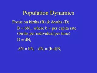
Hunting and Gathering Demographic Characteristics • Band Size ~ 25 – 50 individuals • Deme (a.k.a. breeding population) • ~ 175 – 475 individuals • Incest prohibitions, uneven sex ratios • Polygyny • Density < .01/sq km • Growth rates .5% - 2%/year
Todd A. Surovell 2003 “Simulating Coastal Migration in New World Colonization” Current Anthropology
Simulation set up • 77 cells arranged 200 km long linearly arranged along coast • Parameters • Cell width • Maximum population growth rate • Leapfrog distance • Coastal return rate • Inland return rate • Goal : Get populations to Monte Verde before they move far inland
Simulation Structure • A. Coastal migration into unoccupied cells occurs when the number of individuals exceeding the optimum can improve their return rates by moving into unoccupied territory. Inland migration occurs when coastal returns fall below maximum inland returns. • B. Population density versus status accepting or rejecting immigrants. Coastal migration between occupied cells occurs when an individual can improve returns by joining another population and that population can improve return rates by having an individual join, a condition met only when population densities for the destination cells are below the optimum. • C. The "base model" structure and parameter settings.
Simulation Results • Goal (almost) achieved by settings: • Cell width 50 km • Leapfrog distance 1000 km • Optimal coastal pop density = 0.0033/sq km • Coastal return rates set to 36x Inland rates. • Growth rate 0.5% • Not so realistic!
David Anderson and J. Christopher Gillam 2000“Paleoindian Colonization of the Americas”American Antiquity
Anderson & Gillam’s Model • Least Cost – Hunting and Gathering colonists will move along the path with the least slope • Digital Elevation Model (DEM) elevation/sq km • 3 x 3 km grid placed at starting point • ArcInfo used to find a least cost movement path. (a spreading operation acting on a roughness layer.
~1000 years But would the isolated groups be viable?
Thule eastward expansion 1000 – 1200 C.E. Independence Fjord
3200 BP 8000 BP