Download
1 / 1
10 likes | 85 Views
Investigating water balance in the Torne-Kalix River system, and model simulations' impact on runoff with varying snow accumulation and latent heat flux. Results highlight the complexity of snowmelt in hydrological processes under different scenarios. The study reflects on the significance of accurate land-atmosphere interactions for future climate projections in high latitude areas.

E N D
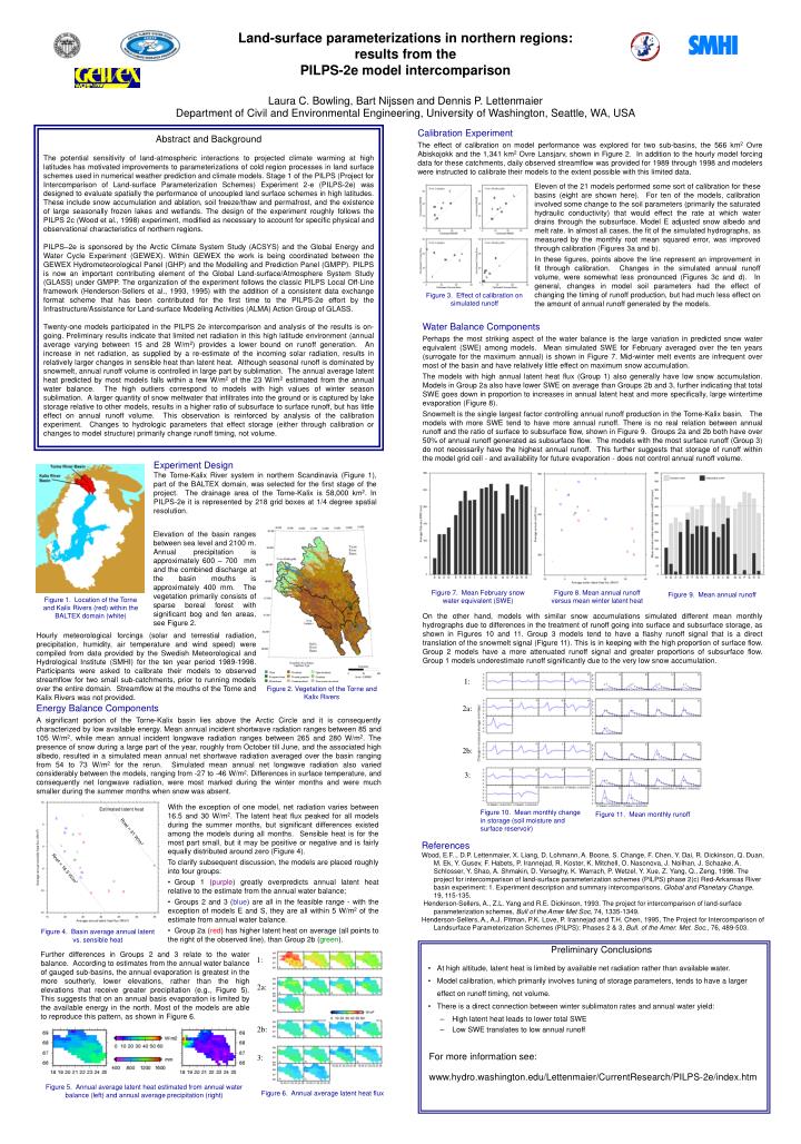
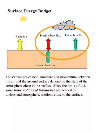
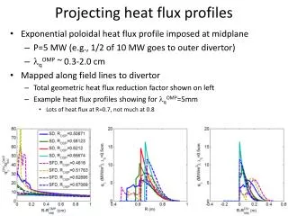
Water Balance Components Perhaps the most striking aspect of the water balance is the large variation in predicted snow water equivalent (SWE) among models. Mean simulated SWE for February averaged over the ten years (surrogate for the maximum annual) is shown in Figure 7. Mid-winter melt events are infrequent over most of the basin and have relatively little effect on maximum snow accumulation. The models with high annual latent heat flux (Group 1) also generally have low snow accumulation. Models in Group 2a also have lower SWE on average than Groups 2b and 3, further indicating that total SWE goes down in proportion to increases in annual latent heat and more specifically, large wintertime evaporation (Figure 8). Snowmelt is the single largest factor controlling annual runoff production in the Torne-Kalix basin. The models with more SWE tend to have more annual runoff. There is no real relation between annual runoff and the ratio of surface to subsurface flow, shown in Figure 9. Groups 2a and 2b both have over 50% of annual runoff generated as subsurface flow. The models with the most surface runoff (Group 3) do not necessarily have the highest annual runoff. This further suggests that storage of runoff within the model grid cell - and availability for future evaporation - does not control annual runoff volume. Experiment Design The Torne-Kalix River system in northern Scandinavia (Figure 1), part of the BALTEX domain, was selected for the first stage of the project. The drainage area of the Torne-Kalix is 58,000 km2. In PILPS-2e it is represented by 218 grid boxes at 1/4 degree spatial resolution. Elevation of the basin ranges between sea level and 2100 m. Annual precipitation is approximately 600 – 700 mm and the combined discharge at the basin mouths is approximately 400 mm. The vegetation primarily consists of sparse boreal forest with significant bog and fen areas, see Figure 2. Figure 1. Location of the Torne and Kalix Rivers (red) within the BALTEX domain (white) Figure 7. Mean February snow water equivalent (SWE) Figure 8. Mean annual runoff versus mean winter latent heat Figure 9. Mean annual runoff On the other hand, models with similar snow accumulations simulated different mean monthly hydrographs due to differences in the treatment of runoff going into surface and subsurface storage, as shown in Figures 10 and 11. Group 3 models tend to have a flashy runoff signal that is a direct translation of the snowmelt signal (Figure 11). This is in keeping with the high proportion of surface flow. Group 2 models have a more attenuated runoff signal and greater proportions of subsurface flow. Group 1 models underestimate runoff significantly due to the very low snow accumulation. Hourly meteorological forcings (solar and terrestial radiation, precipitation, humidity, air temperature and wind speed) were compiled from data provided by the Swedish Meteorological and Hydrological Institute (SMHI) for the ten year period 1989-1998. Participants were asked to calibrate their models to observed streamflow for two small sub-catchments, prior to running models over the entire domain. Streamflow at the mouths of the Torne and Kalix Rivers was not provided. Figure 2. Vegetation of the Torne and Kalix Rivers 1: Estimated latent heat 2a: Rnet = 41 W/m2 2b: Figure 3. Effect of calibration on simulated runoff Rnet = 16.5 W/m2 3: Figure 11. Mean monthly runoff Figure 10. Mean monthly change in storage (soil moisture and surface reservoir) 1: 2a: 2b: 3: Figure 6. Annual average latent heat flux Land-surface parameterizations in northern regions: results from the PILPS-2e model intercomparisonLaura C. Bowling, Bart Nijssen and Dennis P. LettenmaierDepartment of Civil and Environmental Engineering, University of Washington, Seattle, WA, USA Abstract and Background The potential sensitivity of land-atmospheric interactions to projected climate warming at high latitudes has motivated improvements to parameterizations of cold region processes in land surface schemes used in numerical weather prediction and climate models. Stage 1 of the PILPS (Project for Intercomparison of Land-surface Parameterization Schemes) Experiment 2-e (PILPS-2e) was designed to evaluate spatially the performance of uncoupled land surface schemes in high latitudes. These include snow accumulation and ablation, soil freeze/thaw and permafrost, and the existence of large seasonally frozen lakes and wetlands. The design of the experiment roughly follows the PILPS 2c (Wood et al., 1998) experiment, modified as necessary to account for specific physical and observational characteristics of northern regions. PILPS–2e is sponsored by the Arctic Climate System Study (ACSYS) and the Global Energy and Water Cycle Experiment (GEWEX). Within GEWEX the work is being coordinated between the GEWEX Hydrometeorological Panel (GHP) and the Modelling and Prediction Panel (GMPP). PILPS is now an important contributing element of the Global Land-surface/Atmosphere System Study (GLASS) under GMPP. The organization of the experiment follows the classic PILPS Local Off-Line framework (Henderson-Sellers et al., 1993, 1995) with the addition of a consistent data exchange format scheme that has been contributed for the first time to the PILPS-2e effort by the Infrastructure/Assistance for Land-surface Modeling Activities (ALMA) Action Group of GLASS. Twenty-one models participated in the PILPS 2e intercomparison and analysis of the results is on-going. Preliminary results indicate that limited net radiation in this high latitude environment (annual average varying between 15 and 28 W/m2) provides a lower bound on runoff generation. An increase in net radiation, as supplied by a re-estimate of the incoming solar radiation, results in relatively larger changes in sensible heat than latent heat. Although seasonal runoff is dominated by snowmelt, annual runoff volume is controlled in large part by sublimation. The annual average latent heat predicted by most models falls within a few W/m2 of the 23 W/m2 estimated from the annual water balance. The high outliers correspond to models with high values of winter season sublimation. A larger quantity of snow meltwater that infiltrates into the ground or is captured by lake storage relative to other models, results in a higher ratio of subsurface to surface runoff, but has little effect on annual runoff volume. This observation is reinforced by analysis of the calibration experiment. Changes to hydrologic parameters that effect storage (either through calibration or changes to model structure) primarily change runoff timing, not volume. Calibration Experiment The effect of calibration on model performance was explored for two sub-basins, the 566 km2 Ovre Abiskojokk and the 1,341 km2 Ovre Lansjarv, shown in Figure 2. In addition to the hourly model forcing data for these catchments, daily observed streamflow was provided for 1989 through 1998 and modelers were instructed to calibrate their models to the extent possible with this limited data. Eleven of the 21 models performed some sort of calibration for these basins (eight are shown here). For ten of the models, calibration involved some change to the soil parameters (primarily the saturated hydraulic conductivity) that would effect the rate at which water drains through the subsurface. Model E adjusted snow albedo and melt rate. In almost all cases, the fit of the simulated hydrographs, as measured by the monthly root mean squared error, was improved through calibration (Figures 3a and b). In these figures, points above the line represent an improvement in fit through calibration. Changes in the simulated annual runoff volume, were somewhat less pronounced (Figures 3c and d). In general, changes in model soil parameters had the effect of changing the timing of runoff production, but had much less effect on the amount of annual runoff generated by the models. Energy Balance Components A significant portion of the Torne-Kalix basin lies above the Arctic Circle and it is consequently characterized by low available energy. Mean annual incident shortwave radiation ranges between 85 and 105 W/m2, while mean annual incident longwave radiation ranges between 265 and 280 W/m2. The presence of snow during a large part of the year, roughly from October till June, and the associated high albedo, resulted in a simulated mean annual net shortwave radiation averaged over the basin ranging from 54 to 73 W/m2 for the rerun. Simulated mean annual net longwave radiation also varied considerably between the models, ranging from -27 to -46 W/m2. Differences in surface temperature, and consequently net longwave radiation, were most marked during the winter months and were much smaller during the summer months when snow was absent. • With the exception of one model, net radiation varies between 16.5 and 30 W/m2. The latent heat flux peaked for all models during the summer months, but significant differences existed among the models during all months. Sensible heat is for the most part small, but it may be positive or negative and is fairly equally distributed around zero (Figure 4). • To clarify subsequent discussion, the models are placed roughly into four groups: • Group 1 (purple) greatly overpredicts annual latent heat relative to the estimate from the annual water balance; • Groups 2 and 3 (blue) are all in the feasible range - with the exception of models E and S, they are all within 5 W/m2 of the estimate from annual water balance. • Group 2a (red) has higher latent heat on average (all points to the right of the observed line), than Group 2b (green). References Wood, E.F.., D.P. Lettenmaier, X. Liang, D. Lohmann, A. Boone, S. Change, F. Chen, Y. Dai, R. Dickinson, Q. Duan, M. Ek, Y. Gusev, F. Habets, P. Irannejad, R. Koster, K. Mitchell, O. Nasonova, J. Noilhan, J. Schaake, A. Schlosser, Y. Shao, A. Shmakin, D. Verseghy, K. Warrach, P. Wetzel, Y. Xue, Z. Yang, Q., Zeng, 1998. The project for intercomparison of land-surface parameterization schemes (PILPS) phase 2(c) Red-Arkansas River basin experiment: 1. Experiment description and summary intercomparisons, Global and Planetary Change, 19, 115-135. Henderson-Sellers, A., Z.L. Yang and R.E. Dickinson, 1993. The project for intercomparison of land-surface parameterization schemes, Bull of the Amer Met Soc, 74, 1335-1349. Henderson-Sellers, A., A.J. Pitman, P.K. Love, P. Irannejad and T.H. Chen, 1995, The Project for Intercomparison of Landsurface Parameterization Schemes (PILPS): Phases 2 & 3, Bull. of the Amer. Met. Soc., 76, 489-503. Figure 4. Basin average annual latent vs. sensible heat Preliminary Conclusions • At high altitude, latent heat is limited by available net radiation rather than available water. • Model calibration, which primarily involves tuning of storage parameters, tends to have a larger effect on runoff timing, not volume. • There is a direct connection between winter sublimaton rates and annual water yield: • High latent heat leads to lower total SWE • Low SWE translates to low annual runoff Further differences in Groups 2 and 3 relate to the water balance. According to estimates from the annual water balance of gauged sub-basins, the annual evaporation is greatest in the more southerly, lower elevations, rather than the high elevations that receive greater precipitation (e.g., Figure 5). This suggests that on an annual basis evaporation is limited by the available energy in the north. Most of the models are able to reproduce this pattern, as shown in Figure 6. • For more information see: • www.hydro.washington.edu/Lettenmaier/CurrentResearch/PILPS-2e/index.htm Figure 5. Annual average latent heat estimated from annual water balance (left) and annual average precipitation (right)


![Heat Flux [Wm -2 ]](https://cdn3.slideserve.com/5899967/heat-flux-wm-2-dt.jpg)