Download

1 / 2
20 likes | 126 Views
Inversion Process. NW. NE. After the resistivity field survey, the resistance measurements are usually reduced to apparent

E N D
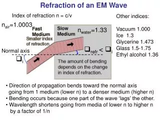
Inversion Process NW NE After the resistivity field survey, the resistance measurements are usually reduced to apparent resistivity values. To obtain a model for the shallow subsurface an inversion needs to be applied. A pseudo section is produced from the apparent resistances measured in the field (See Loc. 3). RES2DINV.exe produces a basic model based on this section using a least squares inversion. 1D profiles of the pseudo section are fed into the model and a modified pseudo section is created. This section shows the resistances you would measure in the field if the model was correct. The model is improved through iterations with the 2nd pseudo section until the two pseudo sections are matching within an error of 5%. Line 2 SW Line 1 a a a B SE A M N a = 4m 1. 2. 3. • Terrameter • Switch Box • Laptop with ERIC.exe NE SW An EM Perspective of Selected Topographic Highs in Transdanubia Ahmed Al-Yaqoobi 2, Judit Petrovszki1, Joseph Michael Court2 1Eötvös Loránd University Faculty of Science 2 University of Leeds, School of Earth and Environment 1st-14th September 2007 Location map Introduction Geological Setting EM31 method Using three parallel electro magnetic methods the project aims to explore the area to the East of Lake Balaton including Öreg Hegy and the Enying ridge in an attempt to explain the spatial distribution and origin of the topographical highs. The methods are quick to apply and provide instant results. The most important formation in the survey area is the Nagyvazsony Limestone Formation, a freshwater limestone. It does not form a continous layer within the formation, but occurs in the form of significant lenses in the white, greenish-white calcareous mud. According to Loczy, sand, loess sandstone, clay and marl can also been observed in the area. A Balatonfelvidek foldtana (1999) Location1 map VLF method A Scintrex ENVI VLF unit was used. VLF uses the high-power military communication transmission in the 15-30 kHz bandwidths which are continuously transmitted by many stations around the world. Eddy currents induced by a VLF magnetic field in conductive material produce secondary magnetic fields with the same frequency as the primary field but with different phase. VLF systems measure the contrast between the primary and secondary field, but do not measure the direct conductivity as does EM. However, VLF systems operate at high frequencies resulting in finer resolution than EM surveys. Milsom 2003 Resistivity method The resisitivity survey was carried out with an ABEM unit. The system uses four electrodes in a Wenner array (current electrodes are A and B and potential electrodes M and N). They are separated by the electrode spacing a whichvaries from 1 to 24 for the 160m spread. The system injects a known current and measures the resulting potential between M and N and calculates the apparent resistance for that spacing. For each spacing the array rolls along the line repeating this process and plotting the results in a pseudo section. The depth of each spacing is approximately (3a)/2. Location2 map NNE SSW Location3 map
Location 1: Line 1 Results Location 2 Results Location 3 Results Pseudo section NNE SSW NE SE NW SW Inversion model Location 1: Line 2 cross-section Conclusion Location 3: Outcrop SW NE EM31 and VLF methods completed preliminary scans before deciding where to centre the more intensive Resistivity survey. Hence the Resistivity scans were focused around the anomalies in question. These anomalies have resistivities in the range of limestone, backed up by the outcrop of freshwater limestone found at location 3. Further work could be completed south of Öreg Hegy, north of location 3, in an attempt to correlate the anomaly across this area and determine if the limestone is discontinuous or was once a homogenous layer. The obtained profiles also provide a valuable contribution to a better understanding of the structure and formation of the Enying ridge. Fresh water limestone found in the dirt track at location 3 line 2, 200m from the start. References: Mlison, J. (2003). Field Geophysics. The Geological Field Guide Series. John wiley and sons Ltd. Parasnis, D. S. (1982). Principles of Applied Geophysics. Chapman and Hall. A Balatonfelvidek foldtana, MAFI Budapest, 1999 Loke, M. H. (2004). Tutorial : 2-D and 3-D electrical imaging surveys Acknowledgements: RES1 group: Al-Rajhi, Mohammed. Veasey, Martin. Pudleiner, E’va. Takacs Peter. For the Resistivity section at Location 2. Gravity group: Hamzah, Hamizah. Ellwood, Helen. Erdős, Zoltan. For the topographic data at Location 1 and 3. Szekely Balazs and Zamolyi Andras for the outcrop photo at Location 3. Thankyou to everyone who helped in attaining the field data, processiong and interpretation.