Download
1 / 42
420 likes | 701 Views
The British Isles. Quiz. 1. Name the capitals of the following countries . A) England B) Scotland C) Wales D) Northern Ireland E) the Republic of Ireland. 1. Name the capitals of the following countries . A) England – London B) Scotland – Edinburgh C) Wales – Cardiff

E N D
TheBritishIsles Quiz
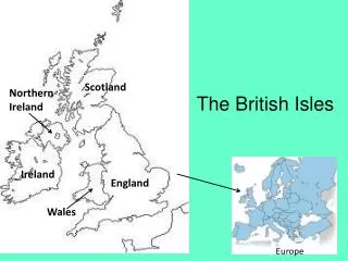
1. Namethecapitalsofthefollowingcountries. • A) England • B) Scotland • C) Wales • D) Northern Ireland • E) the Republic of Ireland
1. Namethecapitalsofthefollowingcountries. • A) England – London • B) Scotland – Edinburgh • C) Wales – Cardiff • D) Northern Ireland – Belfast • E) the Republic of Ireland – Dublin
2. WhatisthemainbodyofwaterseparatingBritainfromIreland? • A) the Irish Sea • B) the North Sea • C) the Celtic Sea • D) the English Channel
2. WhatisthemainbodyofwaterseparatingBritainfromIreland? • A) the Irish Sea
3. NamethelongestriverintheBritishIsles. • A) the Thames • B) the Shannon • C) the Severn • D) the Trent
3. NamethelongestriverintheBritishIsles. • A) the Thames (346 km) • B) the Shannon (386 km) • C) the Severn (354 km) • D) the Trent (298 km)
4. GreatBritainisthe … largestislandintheworld. • A) 6th • B) 7th • C) 8th • D) 9th
5. Connectthecitieswiththeplaces on themap. • A) London • B) Birmingham • C) Glasgow • D) Manchester 2 1 4 3
5. Connectthecitieswiththeplaces on themap. • A) London - 3 • B) Birmingham - 4 • C) Glasgow - 2 • D) Manchester - 1 2 1 4 3
6. Namethemountain range inthepicture. • A) the Southern Uplands • B) the Pennines • C) the Cambrian Mtns. • D) the Cumbrian Mtns.
6. Namethemountain range inthepicture. • B) the Pennines
7. Connectthecountries and thepopulations. • A) England • B) Scotland • C) Wales • D) Northern Ireland • E) the Republic of Ireland • 1) 2,999,000 • 2) 1,789,000 • 3) 51,446,000 • 4) 4,470,000 • 5) 5,194,000
7. Connectthecountries and thepopulations. • A) England • B) Scotland • C) Wales • D) Northern Ireland • E) the Republic of Ireland • 3) 51,446,000 • 5) 5,194,000 • 1) 2,999,000 • 2) 1,789,000 • 4) 4,470,000
8. Nametheisland on theoutlinemap. • A) the Isle of Wight • B) Anglesey • C) the Isle of Man • D) the Isle of Skye
8. Nametheisland on theoutlinemap. • C) the Isle of Man
9. Connectthepictures and places on themap. A) the Lake District B) Land’s End 1 C) the White Cliffs of Dover 2 D) the Giant’s Causeway 3 4
9. Connectthepictures and places on themap. A) the Lake Distric - 2 B) Land’s End - 4 1 C) the White Cliffs of Dover - 3 2 D) the Giant’s Causeway - 1 3 4
10. Namethelargest lake intheBritishIsles. • A) Lough Corrib • B) Loch Ness • C) Lough Neagh • D) Lough Erne
10. Namethelargest lake intheBritishIsles. • A) Lough Corrib (178 km2) • B) Loch Lomond (71 km2) • C) Lough Neagh (388 km2) • D) Lough Erne (109 km2)
11. WhichoftheseisnotBritishCrownDependency? • A) the Isle of Man • B) Jersey • C) Guernsey • D) the Isle of Wight
11. WhichoftheseisnotBritishCrownDependency? • D) the Isle of Wight
12. NamethehighestmountainintheBritishIsles. • A) Ben Macdui • B) Carn Eige • C) Ben Nevis • D) Ben Wyvis
12. NamethehighestmountainintheBritishIsles. • A) Ben Macdui (1,309 m) • B) Carn Eige (1,183 m) • C) Ben Nevis (1,344 m) • D) Ben Wyvis (1,04 m)
13. TheChannel Tunnel isbuiltbeneath … • A) the North Channel • B) the Strait of Dover • C) St George’s Channel • D) the Menai Stratit
13. TheChannel Tunnel isbuiltbeneath … • B) the Strait of Dover
14. Connecttheflags and theplaces on themap. A) 3 B) C) 1 D) 2 4
14. Connecttheflags and theplaces on themap. A) Cornwall - 2 3 B) Jersey - 4 C) Northern Ireland -1 1 D) Orkney - 3 2 4
15. Addthegeographicalnamein front ofthedogbreed. C) … terrier A) … buldog B) … terrier D) … setter
15. Addthegeographicalnamein front ofthedogbreed. C) Scottish terrier • English • buldog B) Irish terrier D) Irish setter
16. WhichofthesecitiesisnotsituatedinEngland? • A) Cork • B) Bristol • C) York • D) Leeds
17. Which range separatesScotland and England? • A) the Southern Uplands • B) the Grampians • C) the Cheviot Hills • D) the Northwest Highlands
17. Which range separatesScotland and England? • C) the Cheviot Hills
18. Connectthepictures and places on themap. A) the Wash B) the Needles C) the Peak District 1 2 4 D) the North York Moors 3
18. Connectthepictures and places on themap. A) the Wash - 2 B) the Needles - 3 C) the Peak District - 4 1 2 4 D) the North York Moors - 1 3
19. Namethedeepest lake intheBritishIsles. • A) Loch Morar • B) Loch Ness • C) Loch Lomond • D) Loch Lochy
19. Namethedeepest lake intheBritishIsles. • A) Loch Morar (310 m) • B) Loch Ness (230 m) • C) Loch Lomond (190 m) • D) Loch Lochy (162 m)
20. Connecttheislandgroupswiththeplaces on themap. • A) the Shetland Islands • B) the Orkney Islands • C) the Isles of Scilly • D) the Hebrides 3 2 1 4
20. Connecttheislandgroupswiththeplaces on themap. • A) the Shetland Islands - 3 • B) the Orkney Islands - 2 • C) the Isles of Scilly - 4 • D) the Hebrides - 1 3 2 1 4
21. Tie-breakquestion. A B C D